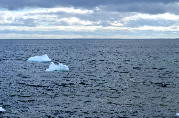
Let us consider in detail the relief of the bottom of the Atlantic Ocean. This topic is presented superficially in many sources. Therefore, the question is relevant for many: "Where can I find a description of the Atlantic Ocean?" Indeed, sometimes a deep study of this topic is required. In this article, we have tried to cover this issue as much as possible.
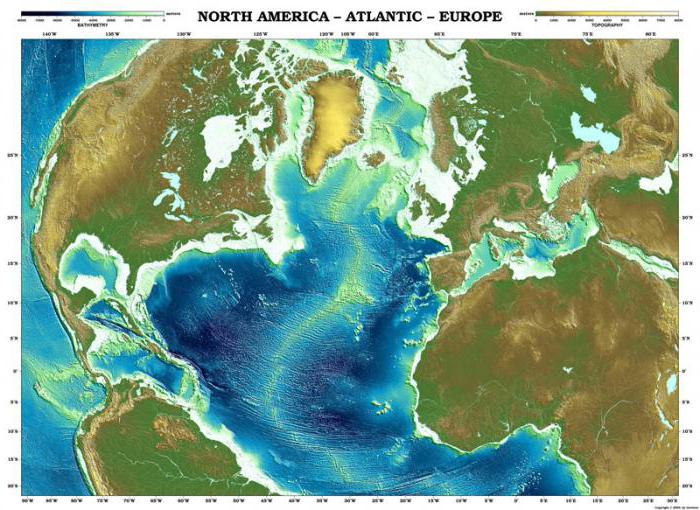
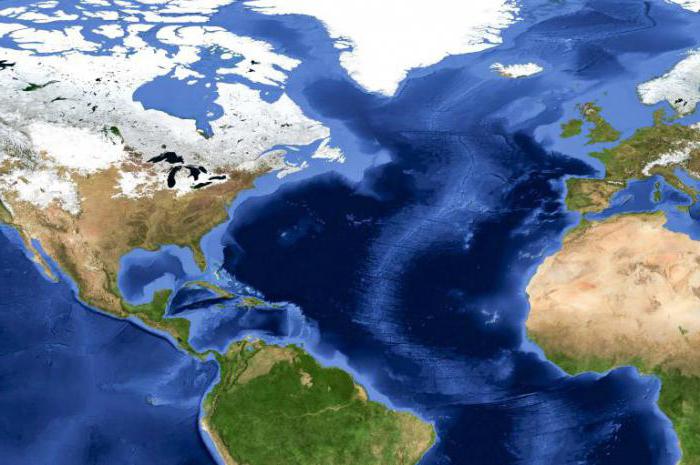
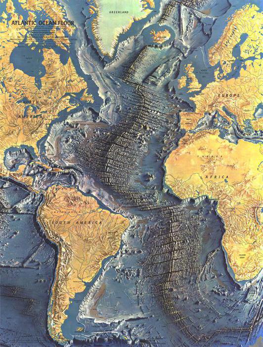
Starting to describe the bottom topography, we note that the Mid-Atlantic Ridge is its main orographic element. In terms of area, it is only slightly smaller than the ocean floor (24.6% and 37.6%, respectively). This ridge divides the entire ocean into two parts. They are roughly equal in area. General information about the Atlantic Ocean, as well as general knowledge of geography, will allow you to better understand what this article is about. In order to better imagine the location of the ocean of interest to us, we suggest that you familiarize yourself with the map.
West of the mid-ridge
The Newfoundland Range lies to the west of the Median Range. The Rio Grande Plateau, the Ceara Rise, the Barracuda Ridge and the Bermuda Plateau, as well as the protrusions of the Mid-Atlantic Ridge and the margins of the submerged continents, divide the western half of the oceanic bed into the Argentinean, Brazilian, Guiana (Guyanese), North American, Newfoundland and Labrador basins . The Norwegian-Greenland basin and the Baffin Sea are usually considered as parts of another ocean - the Arctic Ocean.
Labrador and Newfoundland basins
Let's continue the story of what constitutes the topography of the bottom of the Atlantic Ocean. Let us briefly describe two basins - Labrador and Newfoundland (the greatest depth of the latter is 5160 meters). They, in essence, form a single whole. Their main part is occupied by a flat abyssal plain. In the submeridional direction, it is crossed by the abyssal valley of Hazen. The Newfoundland Basin is fenced off from the south by the ridge of the same name. It, as shown by various seismoacoustic studies, is a giant accumulative form, which is associated with the movement of sedimentary material by deep-sea currents.
Basins North American, Guiana and Ceara
The North American Basin is one of the largest basins that marked the topography of the bottom of the Atlantic Ocean. A brief description of it will continue our story. The greatest depth of the basin is 7110 meters. The Bermuda Plateau is located almost in the center of its northern part. The volcanic massif Corner (otherwise called the Corner Rise) and the Kelvin Mountains also stand out here. The undulating abyssal plain extends from the Bermuda Plateau to the south. On the periphery of the basin are the flat abyssal plains of Nares, Hatteras and Som. The North American Basin borders on the southwest with the Blake Bahama Range, as well as with the Outer Antilles Shaft. The latter extends along the Puerto Rico Trench. It separates, together with the blocky ridge Barracuda, located on its continuation, the Guiana Basin from the North American. The influx of sedimentary terrigenous material ensures the almost universal development of a flat abyssal plain, called the Demerara Plain, within the Guiana Basin. The Guiana Basin has a maximum depth of 5109 meters in the northwestern part, characterized by a mostly hilly terrain. It is separated from the Seara Basin by a small uplift of Ceara, complicated by underwater volcanoes. The greatest depth of the latter is 4700 meters. The bottom of this basin is occupied by a flat plain of the same name. It is necessary to note 2 more abyssal valleys. These are the Wild, the depth of which reaches 250 meters (connects the Guiana and North American basins), and Pernambuco (connects the Brazilian and Guiana basins).
brazilian basin
The largest basin in the western part of the ocean is the Brazilian Basin. Here the relief of the bottom of the Atlantic Ocean is predominantly hilly. On the plain of Pernambuco, a small section of the basin, it is undulating. Many underwater volcanoes are located in the Brazilian Basin. Some rise above sea level, forming volcanic islands (Martin Vas, Trinidad, Fernando de Noronha). Latitudinal fault zones are subject to the location of seamounts.
The Brazilian Basin is separated from the South by the Rio Grande Plateau from the Argentinean Basin. The relief of the plateau is very complex. Individual seamounts rise above the plateau-like surfaces.
The eastern part looks like a ridge, narrow, with a flat top. It is elongated in the meridional direction. Between the underwater margin of the mainland of South America and the plateau passes Vima - an abyssal valley, through which bottom waters flow from the Argentinean to the Brazilian Basin. A significant part of the Argentinean bottom is occupied by an undulating plain. A flat, narrow abyssal plain is located on the western margin of the basin, and in the southern part there is a large accumulative underwater form - the Sapiola Ridge. Its formation is associated with the supply of nepheloid and bottom sediments by the bottom Antarctic current. There are no large seamounts in the Argentine Basin, but seismoacoustic profiles convey information that several mountains, whose relative height reaches 2-2.5 km, are buried under the sediment layer.
The South Antilles Outer Swell is a vodka uplift located south of the Argentine Basin. The African-Antarctic Basin is located to the south, between Antarctica and the mid-ocean ridge. The conditional boundary between the Indian and Atlantic oceans is drawn at 20°E. e. If we take this boundary into account, then only the western part of the basin with a flat abyssal plain called Wedella is located in the Atlantic Ocean. The relief of the abyssal hills is typical of the northern part of the basin.
What is located at the depth of the Atlantic Ocean in its eastern part?

The relief of the bottom of the world ocean is quite complex and heterogeneous, it consists of many elements. The Atlantic Ocean is no exception. Its bed in the eastern part is characterized by the presence of the Lateral or Azores-Biscay Range, the Gorringe Massif, the uplift and the Canary Islands, the Sierra Leone Plateau, the Whale Ridge and the Guinea Uplift. They divide the entire eastern part of the ocean into Western European (the greatest depth is 5023 meters), Canary (6549 meters), Iberian (5815 meters), Sierra Leone (6040 meters), Cape Verde (7282 meters), Angolan (6050 meters), Guinean (5215 meters) and Cape (5457 meters) basins. Between Rockall, an underwater height, and the Icelandic-Farrere threshold, there is the Western European Basin.
Western European Basin
The bottom of the basin is mainly an abyssal hilly plain, only in and also to the north-west of it is the Biscay flat plain stretched. From north to south, the bottom is cut by a large abyssal Mori valley, the length of which is about 3500 km. It is morphologically similar to the Hazen Valley. The valley is accompanied for a long distance by accumulative shafts, reaching a height of 50 meters. Two huge accumulative forms stand out in the northern part of this basin. These are the "sedimentary ridges" of Feni and Gardar. Their formation is associated with an increased supply of sedimentary material from the Icelandic-Faroe threshold. The Iberian basin, small in size, is occupied in the central part by a flat abyssal plain. It is connected to the Biscay Plain by the Theta Gorge.
South of the Iberian Basin
The relief of the bottom of the Atlantic Ocean south of the Iberian Basin is very rugged. Its features are determined by the presence here of the Gorinj ridge, blocky-volcanic, as well as a seamount of the same name, the Madeira rise and a group of other seamounts. The main features of the Atlantic Ocean floor in this area also include the presence of many underwater volcanoes. According to the structure of the surface, the bottom of the Zelenomysskaya basin, as well as the vast Canary (the greatest depth is 6549 meters) can be divided into 3 submeridional zones: the eastern one, the oceanic crust within which is covered by a completely inclined plain at the foot of the mainland; middle abyssal plain, flat and narrow; hilly western. Elements of the underwater margin of the African continent are also the volcanic uplifts of the Canary Islands (4 active volcanoes are among them) and with an active volcano. All this and much more is hidden in the depths of the Atlantic Ocean.

The uplift of Sierra Leone is characterized by very high velocities (7-7.3 km/s) of seismic waves. This is due to the intrusion of ultrabasic rocks into the Earth's crust, as well as to the strong metamorphization of various crustal rocks. The bottom of such basins as Guinea and Sierra Leone is occupied by flat plains, which are surrounded by abyssal hills. The greatest depths of these basins are 5212 and 6040 meters, respectively.
Cameroon Rift Zone
The broad Guinea Rise extends northeast from a lava plateau, vast and located in the eastern part of the Mid-Atlantic Ridge, near Saint Helena. The Cameroon Fault Zone is the most characteristic element of this uplift. The volcanic structures of the seamount Shirshova, as well as the islands of Palanga, Principe, Sao Tome and Macias-Nguema-Biyogo are associated with it. The fault zone further stretched within the continent of Africa. Cameroon, an active volcano, as well as several Central Saharan ones, among which there are also active ones, are confined to it.
Angolan Basin
The bottom of the Angolan Basin, which lies to the southeast and south of the Guinea Rise, is also overlapped to a large extent by inclined plumes of the foot of the mainland, including the vast alluvial fan of the Congo, a submarine canyon. A group of seamounts is located in the southernmost corner of the Angolan Basin. These mountains have a common base. The most significant of them is the city of Würst (its relative height is about 4 km).
whale range
The whale range is a mountain block structure. It consists of 3 large blocks, which are separated by saddles. The whale range is characterized by a flattened summit surface and steep slopes. The evenness of the summit surface is associated to a large (and possibly the main) extent with the accumulation of calcareous deposits.
Cape Basin
The Cape Basin, located south of the Whale Ridge, is distinguished by the fact that the relief of the abyssal hills is mainly developed here. In addition, the depths of the Atlantic Ocean are fraught with many volcanic mountains. They are concentrated mainly in the southern part of this basin. A group of these mountains separates the Cape Basin from the Agulhas Basin. Agulhas is considered mainly as part of a bed. It is morphologically similar to the Cape Basin.
Now you know what topography of the bottom of the Atlantic Ocean is at the moment. It is gradually changing, although significant changes occur very slowly. After all, the continents drift at a speed of only about 1-2 cm per year. Other processes that affect it are also very slow. Therefore, the main features of the topography of the bottom of the Atlantic Ocean remain unchanged.
What explains the features of the relief of the Atlantic Ocean?
Why is the bottom relief exactly the way it is? Let's figure it out. The features that the topography of the bottom of the World Ocean has, scientists today can explain with specific reasons. In particular, the Atlantic Ocean is believed to have formed as a result of the opening of a rift in the axial zone of the Mid-Atlantic Ridge. All the features of the structure and relief of the bottom of this ocean are explained by the fact that the 4 main plates (Antarctic, African, Eurasian and American) move mutually.
The history of the study of the Atlantic Ocean began in ancient times. Meanwhile, its depths have not yet been fully explored. It is quite possible that the history of the exploration of the Atlantic Ocean will continue with new interesting discoveries.