The ocean receives a lot of heat from the Sun. Occupying a large area, it receives more heat than land.
But the sun's rays heat only the top layer of water, only a few meters thick. Heat is transferred down from this layer as a result of constant mixing of water. But it should be noted that the water temperature decreases with depth, first abruptly, and then smoothly. At depth, water is almost uniform in temperature, since the depths of the oceans are mainly filled with waters of the same origin, forming in the polar regions of the Earth. At a depth of more than 3-4 thousand meters, the temperature usually ranges from +2°C to 0°C.
Temperature surface waters also varies and is distributed depending on geographic latitude. The farther from the equator, the lower the temperature. This is due to the different amount of heat that comes from the Sun. Due to the spherical shape of our planet, the angle of incidence of the sun's ray at the equator is greater than at the poles, therefore equatorial latitudes receive more heat than polar latitudes. The highest temperatures of ocean waters are observed at the equator - +28-29°C. To the north and south of it, the water temperature decreases. Due to the proximity of cold Antarctica, the rate of temperature decrease in the south is slightly faster than in the north.
For temperature sea water The climate of the surrounding areas also influences. It is especially high in seas surrounded by hot deserts, for example in the Red Sea - up to 34°C, in the Persian Gulf - up to 35.6°C. In temperate latitudes, temperatures vary depending on the time of day.
In addition to the geographic latitude and climate of the surrounding areas, currents also influence the temperature of ocean waters. Warm currents carry away warm waters from the equator to temperate latitudes, and cold ones carry cold water from the polar regions. Such movement of water contributes to a more uniform distribution of temperatures in water masses.
The highest average temperature at the surface of the water in Pacific Ocean equal to 19.4°C. Second place (17.3°C) is occupied by the Indian Ocean. On the third place - Atlantic Ocean, having an average temperature of about 16.5°C. The lowest water temperature in Severny Arctic Ocean- on average slightly above 1°C. Consequently, for the entire World Ocean, the average temperature of surface waters is about 17.5°C.
So, the ocean absorbs 25-50% more heat than land, and this is its huge role for living beings on the entire planet. The sun heats its water all summer, and in winter this heated water gradually releases heat to the atmosphere. Thus, the World Ocean is something like the “central heating boiler” of the Earth. Without it, such severe frosts will come on Earth that all living things will die. It has been calculated that if the oceans did not conserve their heat so carefully, the average temperature on Earth would be -21°C, which is as much as 36°C lower than what we actually have.
As in the Pacific Ocean, north and south of the central regions climate and waters of the Atlantic Ocean are getting colder. The heterogeneity of the ocean climate also affects the shores of the Atlantic (Fig. 34).
In the east and west of one geographical zone The climate and waters are also somewhat different. So, in the western part of the temperate zone they are colder than in the eastern part. In the west there is less precipitation. This phenomenon is explained by the circulation of the atmosphere and surface waters, which is closely related to the Icelandic minimum, i.e. area of low atmospheric pressure. In the tropical zone, on the contrary, in the west the climate is warmer and more humid than in the east. The waters are also warmer in the west (Fig. 35). This is due to the movement of air and water masses around areas of high atmospheric pressure - North Atlantic maximum in the Northern Hemisphere and South Atlantic High in the Southern Hemisphere.
Significantly increase the temperature difference between the western and eastern parts of the tropical zone sea currents(Fig. 36).
The main role here is played by Golf stream. This is the largest and most powerful warm current among all the warm currents of the World Ocean. It carries 80 times more water than all the rivers on the globe. In its southern part, the Gulf Stream has a width of 75 km, the thickness of the water flow here reaches 700-800 m. The water mass (its temperature is about +28 ° C) moves at a speed of almost 10 km/h. The main source of food for the Gulf Stream is the Caribbean Sea. A huge mass of water, which trade wind currents bring here, ends up in the Gulf of Mexico. The water level here is rising, and its excess is released through the Strait of Florida into open ocean. This is how a current arises, the name of which means “bay current.”
Gulf Stream with Canary And Northern Trade Wind Currents forms a huge circulation of currents in the northern tropical zone. The water masses in it, under the influence of atmospheric circulation, as well as in the Pacific Ocean, move clockwise. At the same time, like the Pacific Ocean in the southern tropical zone of the Atlantic, sea currents - Western Winds And South Passatnoe - move in a counterclockwise direction.
The Atlantic Ocean is very salty, although the salinity of the waters varies in different parts of it. It is highest in tropical latitudes - 37.5 ‰. In places where powerful rivers flow into the ocean, the salinity of ocean waters decreases to 18 ‰, and in the relatively shallow Baltic Sea it is only 8 ‰. Material from the site
The waters of the Atlantic are the most transparent among the waters of the World Ocean. So, in the marginal sea of the Atlantic Ocean - Weddell Sea— objects are visible at a depth of 79 m. This is a kind of record for water transparency. One of the most transparent seas of the World Ocean is also Sargasso Sea. Objects are visible in it at a depth of 66.5 m.
How is sea water transparency determined? For over 100 years it has been determined using Secchi disk- a white disk with a diameter of 30 cm. It is lowered in a horizontal position from the side of the ship and the depth to which the white spot remains visible under water is noted. The record for sea water transparency was recorded in 1987 in the Weddell Sea off the coast of West Antarctica. The white disk was visible at a depth of almost 79 m, and only at around 80 m did it disappear.
The Atlantic climate, like the Pacific climate, is extremely diverse and varies both from north to south and from west to east.
On this page there is material on the following topics:
Report on the Canary Current
Atlantic ocean bottom topography
Fauna of the Atlantic Ocean report 5th grade
Atlantic Sea Report
Relief of the bottom of the Atlantic Ocean - a brief summary
Questions about this material:
Physical geography of continents and oceans
OCEANS
ATLANTIC OCEAN
Climate and hydrological conditions of the Atlantic Ocean
It was already noted above similarity the geographical location of the Atlantic and Pacific oceans, which cannot but influence the peculiarities of climate formation and hydrological conditions of each of them. Approximately the same extent from north to south, between the subpolar latitudes of both hemispheres, the much larger size and massiveness of the land bordering the oceans in the northern hemisphere compared to the southern, relatively weak connection and limited possibilities of water exchange with the Arctic Ocean and openness towards other oceans and the Antarctic basin in the south - all these features of both oceans determine the similarity between them in the distribution of centers of atmospheric action, the direction of winds, the temperature regime of surface waters and the distribution of precipitation.
At the same time, it should be noted that the Pacific Ocean is almost twice as large in surface area as the Atlantic Ocean and its widest part is in the intertropical space, where it has a connection with the warmest part of the Indian Ocean through the interisland seas and straits of Southeast Asia. The Atlantic Ocean in the equatorial latitudes has the smallest width, from the east and west it limit massive landmass of Africa and South America. These features, as well as differences in the age and structure of the ocean basins themselves, create the geographical individuality of each of them, with individual features being more characteristic of the northern parts of the oceans, while in southern hemisphere the similarities between them are expressed to a much greater extent.
Main pressure systems over the Atlantic Ocean, which determine the meteorological situation throughout the year, is the equatorial depression, which, as in the Pacific Ocean, is somewhat expanded towards the summer hemisphere, as well as quasi-stationary subtropical areas of high pressure, along the periphery of which trade winds flow towards the equatorial depression winds are northeasterly in the northern hemisphere and southeasterly in the southern hemisphere.
In the southern hemisphere, where the ocean surface is interrupted by land only in relatively small areas, all the main pressure systems stretched out along the equator in the form of sublatitudinal belts, separated by frontal zones, and during the year they only slightly shift following the sun towards the summer hemisphere.
in winter In the southern hemisphere, the southeast trade wind penetrates to the equator and slightly further north, towards the Gulf of Guinea and the northern part of South America. The main precipitation at this time falls in the northern hemisphere, and dry weather prevails on both sides of the Southern Tropic. South of 40° S. Western transport is active, winds blow, often reaching gale force, thick clouds and fogs are observed, and heavy precipitation falls in the form of rain and snow. This " roaring forties» latitudes, which have already been discussed in the sections devoted to the nature of the Pacific and Indian Oceans. From Antarctica, in high latitudes, southeastern and eastern winds blow, with which icebergs and sea ice are blown to the north.
In the warm half of the year the main directions of air flow remain the same, but the equatorial trough expands to the south, the southeast trade wind intensifies, rushing into an area of low pressure over South America, and precipitation falls along its eastern coast. Western winds in temperate and high latitudes remain the dominant atmospheric process.
Natural conditions in subtropical and temperate latitudes of the North Atlantic differ significantly from those characteristic of the southern part of the ocean. This is due both to the characteristics of the water area itself and to the size of the land bordering it, the temperature and air pressure above which change sharply throughout the year. The most significant contrasts in pressure and temperature are created in winter, when over ice-covered Greenland, North America and in the interior parts of Eurasia, due to cooling, centers of high pressure and temperature are formed not only over land, but also over clogged with ice interisland waters of the Canadian Arctic Archipelago can be very low. The ocean itself, with the exception of the coastal northwestern part, even in February maintains a surface water temperature of 5 to 10 °C. This is due to the influx of warm waters from the south into the northeastern part of the Atlantic and the lack of cold water from the Arctic Ocean.
In the north In winter, a closed area of low pressure forms in the Atlantic Ocean - the Icelandic, or North Atlantic, minimum. Its interaction with the Azores (North Atlantic) maximum, located at the 30th parallel, creates a predominant westerly wind flow over the North Atlantic, carrying moist-unstable relatively warm air from the ocean to the Eurasian continent. This atmospheric process is accompanied by precipitation in the form of rain and snow at positive temperatures. A similar situation applies to the ocean area south of 40° N. and in the Mediterranean, where it rains at this time.
During the summer season In the northern hemisphere, an area of high pressure remains only over the Greenland ice sheet, low pressure centers are established over the continents, and the Icelandic low weakens. Western transport remains the main circulation process in temperate and high latitudes, but it is not as intense as in winter. The Azores High intensifies and expands, and most of the North Atlantic, including the Mediterranean Sea, is under the influence of tropical air masses and does not receive precipitation. Only off the coast of North America, where moisture-unstable air enters along the periphery of the Azores High, does monsoon-type precipitation occur, although this process is not at all as pronounced as on the Pacific coast of Eurasia.
In summer and especially in autumn, over the Atlantic Ocean between the northern tropic and the equator (as in the Pacific and Indian oceans at these latitudes), tropical hurricanes, which with enormous destructive force sweep over the Caribbean Sea, the Gulf of Mexico, Florida, and sometimes penetrate far to the north, up to 40° N. latitude.
Due to the observed last years Due to high solar activity off the coast of the Atlantic Ocean, the frequency of tropical hurricanes has increased significantly. In 2005, three hurricanes hit the southern coast of the United States - Katrina, Rita and Emily, the first of which caused enormous damage to the city of New Orleans.
System surface currents Atlantic Ocean in general outline repeats their circulation in the Pacific Ocean.
In the equatorial latitudes there are two trade wind currents - the Northern Trade Wind and the Southern Trade Wind, moving from east to west. Between them, the Intertrade Countercurrent moves east. The Northern Trade Wind Current passes near 20° N latitude. and off the coast of North America it gradually deviates to the north. The Southern Trade Wind Current, passing south of the equator from the coast of Africa to the west, reaches the eastern protrusion of the South American continent and at Cape Cabo Branco it divides into two branches running along the coast of South America. Its northern branch (Guiana Current) reaches the Gulf of Mexico and, together with the North Trade Wind Current, takes part in the formation of the system of warm currents of the North Atlantic. The southern branch (Brazil Current) reaches 40° S, where it meets a branch of the circumpolar current Western winds- cold Falkland Current. Another branch of the Western Winds current, carrying relatively cold waters to the north, enters the Atlantic Ocean off the southwestern coast of Africa. This Benguela Current is an analogue of the Peruvian Current of the Pacific Ocean. Its influence can be traced almost to the equator, where it flows into the South Trade Wind Current, closing the southern Atlantic gyre and significantly reducing the temperature of surface waters off the coast of Africa.
General picture of surface currents North Atlantic much more complex than in the southern part of the ocean, and also has significant differences from the current system of the northern part of the Pacific Ocean.
A branch of the North Trade Wind Current, strengthened by the Guiana Current, penetrates through the Caribbean Sea and the Yucatan Strait into the Gulf of Mexico, causing a significant increase in water levels there compared to the ocean. As a result, a powerful waste current arises, which, skirting Cuba, through the Strait of Florida enters the ocean called Gulf Stream(“stream from the bay”). This is how the greatest system of warm surface currents in the World Ocean arises off the southeastern coast of North America.
Gulf Stream at 30°N. and 79°W merges with the warm Antilles Current, which is a continuation of the North Trade Wind Current. The Gulf Stream then passes along the edge of the continental shelf to approximately 36°N. At Cape Hatteras, deviating under the influence of the Earth's rotation, it turns east, skirting the edge of the Great Newfoundland Bank, and goes to the shores of Europe under the name of the North Atlantic Current, or “Gulf Stream Drift”.
When leaving the Strait of Florida, the width of the Gulf Stream reaches 75 km, depth - 700 m, and current speed - from 6 to 30 km/h. The average surface water temperature is 26 °C. After merging with the Antilles Current, the width of the Gulf Stream increases 3 times, and the water flow is 82 million m 3 /s, i.e. 60 times higher than the flow of all rivers on the globe.
North Atlantic Current at 50°N. and 20°W is divided into three branches. The northern one (Irminger Current) goes to the southern and western shores of Iceland, and then goes around the southern coast of Greenland. The main middle branch continues to move northeast, towards the British Isles and the Scandinavian Peninsula, and goes into the Arctic Ocean called the Norwegian Current. The width of its flow north of the British Isles reaches 185 km, depth - 500 m, flow speed - from 9 to 12 km per day. The surface water temperature is 7... 8 °C in winter and 11... 13 °C in summer, which is on average 10 °C higher than at the same latitude in the western part of the ocean. The third, southern, branch penetrates the Bay of Biscay and continues south along the Iberian Peninsula and the northeastern coast of Africa in the form of the cold Canary Current. Flowing into the North Trade Wind Current, it closes the subtropical gyre of the North Atlantic.
The northwestern part of the Atlantic Ocean is mainly influenced by cold waters coming from the Arctic, and different hydrological conditions develop there. In the area of the island of Newfoundland, the cold waters of the Labrador Current move towards the Gulf Stream, pushing the warm waters of the Gulf Stream away from the northeastern coast of North America. In winter, the waters of the Labrador Current are 5...8 °C colder than the Gulf Stream; all year round their temperature does not exceed 10 °C; they form a so-called “cold wall”. The convergence of warm and cold waters promotes the development of microorganisms in the upper layer of water and, consequently, the abundance of fish. Particularly famous in this regard Great Newfoundland Bank where they catch cod, herring and salmon.
To approximately 43°N. The Labrador Current carries icebergs and sea ice, which, combined with the fogs characteristic of this part of the ocean, pose a great danger to shipping. A tragic illustration is the disaster of the Titanic, which sank in 1912 800 km southeast of Newfoundland.
Temperature The water on the surface of the Atlantic Ocean, as in the Pacific, is generally lower in the southern hemisphere than in the northern. Even at 60° N latitude. (with the exception of the northwestern regions), the temperature of surface waters fluctuates throughout the year from 6 to 10 °C. In the southern hemisphere at the same latitude it is close to 0 °C and in the eastern part it is lower than in the western.
The warmest surface waters of the Atlantic (26...28 °C) are confined to the zone between the equator and the Northern Tropic. But even these maximum values do not reach the values observed at the same latitudes in the Pacific and Indian Oceans.
Indicators salinity The surface waters of the Atlantic Ocean are much more diverse than in other oceans. The highest values (36-37% o - the maximum value for the open part of the World Ocean) are characteristic of subtropical regions with low annual precipitation and strong evaporation. High salinity is also associated with the influx of salt water from the Mediterranean Sea through the shallow Strait of Gibraltar. On the other hand, large areas of the water surface have average oceanic and even low salinity. This is due to large amounts of precipitation (in equatorial regions) and the desalination effect large rivers(Amazon, La Plata, Orinoco, Congo, etc.). In high latitudes, a decrease in salinity to 32-34% o, especially in summer, is explained by the melting of icebergs and floating sea ice.
The structural features of the North Atlantic basin, the circulation of the atmosphere and surface waters in subtropical latitudes determined the existence here of a unique natural formation called Sargasso Sea. This is a section of the Atlantic Ocean between 21 and 36 latitudes. and 40 and 70° W. The Sargasso Sea is “boundless, but not limitless.” Its peculiar boundaries can be considered the currents: the North Trade Wind in the south, the Antilles in the southwest, the Gulf Stream in the west, the North Atlantic in the north and the Canary in the east. These boundaries are moving, so the area of the Sargasso Sea fluctuates between 6 and 7 million km 2. Its position roughly corresponds to the central part of the Azores baric maximum. Within the Sargasso Sea are the volcanic and coral islands of the Bermuda archipelago.
In order to determine which climatic zones The Atlantic Ocean is located, just look at the world map. It stretches from the northern ice islands and ends off the coast of Antarctica, crossing the equator and all the surrounding areas. natural areas. In each individual area, weather conditions over the waters are different. In some places trade winds prevail, in others monsoons prevail. There are areas with low pressure, and there are areas with very high pressure. Therefore, now we will look in more detail in which climatic zones the Atlantic Ocean is located, and also highlight their main features.
Atlantic data
In terms of its parameters and volume of water masses, the Atlantic Ocean ranks second in the world after the Pacific. It is located between the shores of Europe and between Africa and In the North, it originates off the coast of Iceland, and in the South it touches the glaciers of Antarctica. On the territory of this vast water tank There are not so many islands anymore, which is one of its peculiarities. The fact is that the bottom relief of the ocean was formed quite a long time ago, compared, for example, with the Indian one, therefore most of the volcanoes here are dormant and remain in a state of rest. Nevertheless, all the islands that formed here are of volcanic origin, regardless of their parameters. So, we looked at where the Atlantic Ocean is located relative to the continents. Now let's move on to its weather conditions.
Brief information about climate
Despite the fact that the Atlantic has a very impressive meridian extent, the air temperature and humidity here seem to be “evened out” due to water currents. One of them is the Gulf Stream, which carries warm waters from the coast Central America to Northern Europe. Due to the fact that warm waters flow along the western shores of Eurasia, the climate here is very mild and stable.  The Gulf Stream also provides the northern part of the ocean with higher average annual temperatures. The South experiences much greater temperature swings throughout the seasons and more rapid weather changes.
Location features
The position of the Atlantic Ocean relative to the continents is main reason that in the Northern Hemisphere surface waters and air warm up more than in the Southern Hemisphere. The fact is that its width in the upper part of the planet is small compared to the southern part. Here it is located between North America and Europe, which seem to squeeze it. In the South it expands as it lies between the rugged lines of Africa and South America.  Below it is fed by the glaciers of Antarctica, which further cools the southern currents. It is impossible to say with accuracy what the average temperature of the Atlantic Ocean is. We can highlight a constant for the Northern Hemisphere - +17 degrees above zero, and for the Southern Hemisphere - +16.
Polar regions
Let's start with the climatic zones in which the Atlantic Ocean is located near the polar coasts. In the North, it does not reach the Arctic zone, therefore all waters are in the subarctic. Here, seasonal temperature fluctuations occur in the range of 15 degrees. In summer, the thermometer rises to +4, in winter it drops to 15 or more below zero. 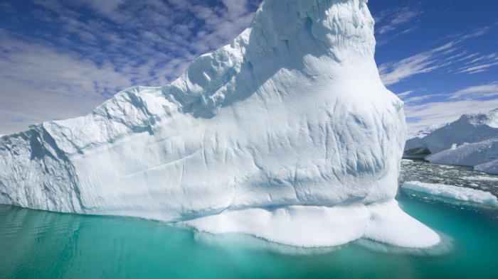 The northern shores of the Atlantic are the zone of the Azores low, and the pressure here is always very low. Average precipitation is 250 mm per year. Weather conditions in the South are much more severe. Seasonal temperature changes are up to 25 degrees. In summer, the thermometer rarely rises above zero, and in winter it drops to -30 and even lower. There is a zone of the South Atlantic Low, and the amount of precipitation is only 100 mm per year.
Temperate latitudes
This is approximately identical in both hemispheres of the planet. It is the place of transition from the dynamic minimum to the maximum, which is located in the tropics. Here, seasonal temperature fluctuations are approximately 10 degrees (a little more in the South, less in the North), and at the same time, compared to the polar latitudes, the humidity is much higher - 1500 mm per year. In temperate latitudes in winter the air cools to no more than -5 Celsius. At the same time, the temperature of the surface waters of the Atlantic Ocean is never below zero, so they do not freeze. In summer in the northern hemisphere it can be warm and dry - up to +25. In the southern part of the ocean the temperature rises to a maximum of +22. 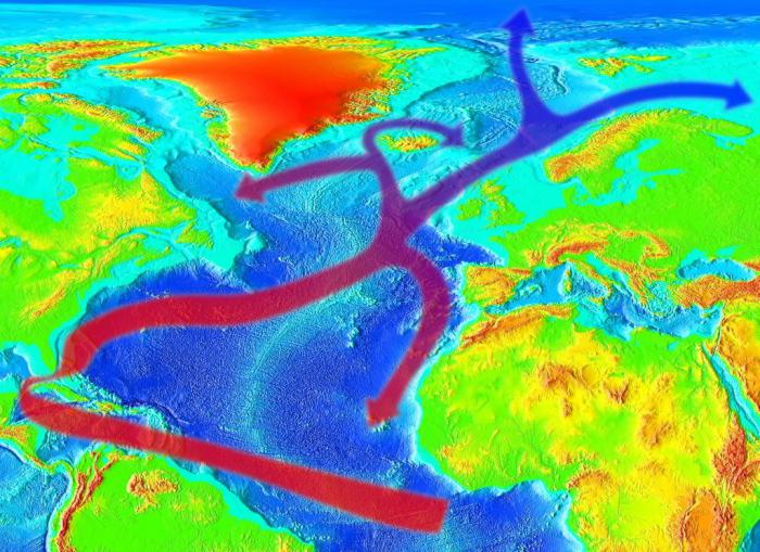
Tropics in the North and South
When studying the climate zones in which the Atlantic Ocean is located, one cannot miss the tropical zone, one of the most extensive on its territory. At the same time, in the North the tropics are hotter and drier than in the South. This weather here is determined by the monsoons that blow from Africa, often causing storms and tornadoes in the ocean in winter period. In summer, the wind strength here decreases and the clouds dissipate. The southern tropics are characterized by light trade winds, which can be brought from the continents or form above the surface of the water. The difference between winter and summer here is not as significant as in the North. In the tropical latitudes of the Atlantic, annual temperature fluctuations are no more than 2 degrees. On average, the thermometer shows +25. Also note that this zone is considered a dynamic maximum. There is very little rainfall here, no more than 200 mm per year, and in some areas - only 50 mm.
Equatorial zone
Between the tropics there is a zone of dynamic minimum. There are always the highest temperatures here, and at the same time very high air humidity. It is caused by cyclones, which form a large veil of clouds and fog over the waters throughout the year. The average temperature of the Atlantic Ocean near the equator is +28 degrees. The precipitation here sometimes amounts to about 3000 mm per year. It is near the equator, between its stripe and the tropics, that there are two archipelagos, which are considered the best places for a beach holiday. These are the Canary Islands, which have a developed infrastructure, and are also a place for lovers of extreme tourism, unusual landscapes and unique equatorial nature.

These 10 little things a man always notices in a womanDo you think your man knows nothing about female psychology? This is wrong. Not a single little thing can be hidden from the gaze of a partner who loves you. And here are 10 things...
0 0
Acquaintance 
Top 10 Broke StarsIt turns out that sometimes even the greatest fame ends in failure, as is the case with these celebrities....
0 0
Celebrities 
10 interesting facts about intimacy, which you probably didn’t know aboutCheck out the most interesting and impressive facts about sexual activity that will surprise you....
The ocean receives a lot of heat from the Sun. Occupying a large area, it receives more heat than land.
But the sun's rays heat only the top layer of water, only a few meters thick. Heat is transferred down from this layer as a result of constant mixing of water. But it should be noted that the water temperature decreases with depth, first abruptly, and then smoothly. At depth, water is almost uniform in temperature, since the depths of the oceans are mainly filled with waters of the same origin, forming in the polar regions of the Earth. At a depth of more than 3-4 thousand meters, the temperature usually ranges from +2°C to 0°C.
The temperature of surface waters also varies and is distributed depending on geographic latitude. The farther from the equator, the lower the temperature. This is due to the different amount of heat that comes from the Sun. Due to the spherical shape of our planet, the angle of incidence of the sun's ray at the equator is greater than at the poles, therefore equatorial latitudes receive more heat than polar latitudes. The highest temperatures of ocean waters are observed at the equator - +28-29°C. To the north and south of it, the water temperature decreases. Due to the proximity of cold Antarctica, the rate of temperature decrease in the south is slightly faster than in the north.
The temperature of sea water is also affected by the climate of the surrounding areas. It is especially high in seas surrounded by hot deserts, for example in the Red Sea - up to 34°C, in the Persian Gulf - up to 35.6°C. In temperate latitudes, temperatures vary depending on the time of day.
In addition to the geographic latitude and climate of the surrounding areas, currents also influence the temperature of ocean waters. Warm currents carry warm water from the equator to temperate latitudes, and cold currents carry cold water from the polar regions. Such movement of water contributes to a more uniform distribution of temperatures in water masses.
The highest average temperature at the surface of the water in the Pacific Ocean is 19.4°C. Second place (17.3°C) is occupied by the Indian Ocean. In third place is the Atlantic Ocean, with an average temperature of about 16.5°C. The lowest water temperature in the Arctic Ocean is on average slightly above 1°C. Consequently, for the entire World Ocean, the average temperature of surface waters is about 17.5°C.
So, the ocean absorbs 25-50% more heat than land, and this is its huge role for living beings on the entire planet. The sun heats its water all summer, and in winter this heated water gradually releases heat to the atmosphere. Thus, the World Ocean is something like the “central heating boiler” of the Earth. Without it, such severe frosts will come on Earth that all living things will die. It has been calculated that if the oceans did not conserve their heat so carefully, the average temperature on Earth would be -21°C, which is as much as 36°C lower than what we actually have.