The geographical location of the African continent on both sides of the equator largely determines the climate of this corner of the globe. It is mainly in the tropics, because the cold, characteristic of temperate latitudes, is not here. But at the same time climatic zones Africa, which diverges from the equator to the north and south, cannot be compared with each other. The structure of the continent is such that in the two hemispheres the same zone has its own characteristics. And in order to learn the local weather and its characteristics, the article presents a map of climatic zones of Africa and their brief description.
The geographical position of the continent
Africa is the second largest continent in the world after Eurasia. It is washed by two oceans - the Atlantic and Indian, a few seas and straits. Geological structure these lands are such that their width is greater in and smaller in the south. This partly affects the climatic zones in Africa that are formed in various regions of Africa. It also largely affects the local relief, the presence of flora and fauna. For example, in the northern part, where all the land is covered with impassable sand, as you understand, plants and animals are at a minimum. But to the south, where there are tropical rainforests or even savannahs, the animal and plant world is richer, it appears to us in all its African identity and uniqueness.
Short description, table
The climatic zones of Africa begin with equatorial.
- At zero latitude is the wettest continent, where the maximum amount of precipitation falls - more than 2000 mm per year.
- It is followed by a subequatorial zone, where the amount of precipitation and natural resources is reduced. In the year there falls no more than 1500 mm of moisture.
- The tropical climate zone is the most extensive region of the continent. Depending on the hemisphere, the amount of precipitation here can vary from 300 to only 50 mm per year.
- covers the edge of the coast in the north of the mainland and the area located in South Africa, in the very south. And there, and there is always windy and wet. In winter, temperatures drop by 7 degrees compared to summer figures. Rainfall is estimated at 500 mm per year.
Equatorial latitudes
Listing all the climatic zones of Africa, special attention should be paid to the equatorial zone, since on this continent it is considered the most unique, the most humid and prolific from the point of view of agriculture. It is located, of course, along zero latitude, and covers such states as Congo, Gabon, Liberia, Ghana, Guinea, Benin, Cameroon and others adjacent to the Gulf of Guinea. A feature of the equatorial climate is that closer to the east it becomes drier, while the maximum amount of precipitation falls on the western parts of the land.
Subequatorial zone
Africa is located in climatic zones characterized by hot temperatures, and a large part of its territory is occupied by subtropics. Here a little drier than at the equator, the jungle and evergreen forests turn into savannahs. A feature of this belt is that in the summer equatorial winds blow here, which bring rain and often fog to the region. In winter, tropical trade winds are observed, which are more arid and very hot, as a result of which the amount of rain decreases and the air temperature rises. In the North of Africa covers such countries as Mali, Chad, Sudan, Ethiopia, Eritrea, etc. In the southern part of the continent it is Tanzania, Kenya, Angola, Zambia Mozambique.

Tropics. Dry and windy
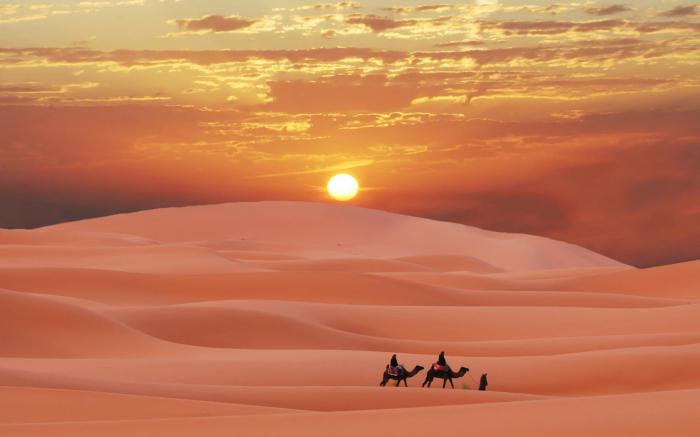
As the table above showed us, it is difficult to imagine the climatic zones of Africa without the tropics, which occupy most of the continent. Their widest strip stretches in the northern part of the continent, covering the Sahara desert and all nearby countries. These are Egypt, the northern territories of Chad, Sudan, and Mali, as well as Mauritania, Tunisia, Morocco, Algeria, and many others. The amount of precipitation is minimal here - about 50 mm per year. The whole territory is covered with sand, blown by dry trade winds. Often there are sandstorms. Among the animals inhabiting the Sahara, insects and reptiles are more common, which are selected from the dunes only at night. In the southern hemisphere, the tropics also occur in the Kalahari desert region. The climate here is very similar to the northern one, but is characterized by a large amount of precipitation and a less sharp daily change in temperature.
Subtropical areas
In conclusion, we consider the extreme climatic zones of Africa - subtropical. They occupy the smallest part of the continent both in the north and in the south, therefore they have little effect on the general weather pattern. So, in the northern part of the continent, this zone extends a thin strip along the Mediterranean coast. Only the highest points of Egypt, Tunisia, Algeria and Morocco, which are washed by the waves of this sea, fall into it. A feature of the local climate is that in the winter there are winds blowing from the west, bringing moisture. Due to this, it is in the cold season that the maximum amount of precipitation falls here - about 500 mm. In summer, winds change to tropical trade winds, which bring heat, drought, and even sand from the Sahara. Rain does not fall at all, the temperature rises to the maximum. In the southern hemisphere, weather conditions are similar. The only feature is that it is a narrow cape, which is washed on all sides by the ocean. Evaporated moisture makes the air humid throughout the year, and precipitation falls here not only in winter, but in all other seasons. 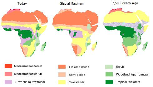
Madagascar and Cape Verde Islands
The climatic zones of Africa cover not only the continent itself, but also the islands that it owns - continental and volcanic. In the east, beyond the waters of the Mozabik Strait, is Madagascar. It immediately falls into two climatic zones - subequatorial and tropical. True, both of them are not as dry here as in Africa itself. It rains often, and the whole island is literally immersed in evergreens and palm trees. lie in the Atlantic, to the west of the Gulf of Guinea. Here the climate is subequatorial, humid, but at the same time very windy. Precipitations are evenly distributed throughout the year.

Conclusion
We have just briefly reviewed all the climatic zones of Africa. Grade 7 is a period when children get acquainted with the natural zones and climate of our children. It is important that the child during this period did not miss anything and could quickly understand what belt we live in, which are located to the south and which, on the contrary, go to the north. This will broaden his horizons and allow better orientation in geography.
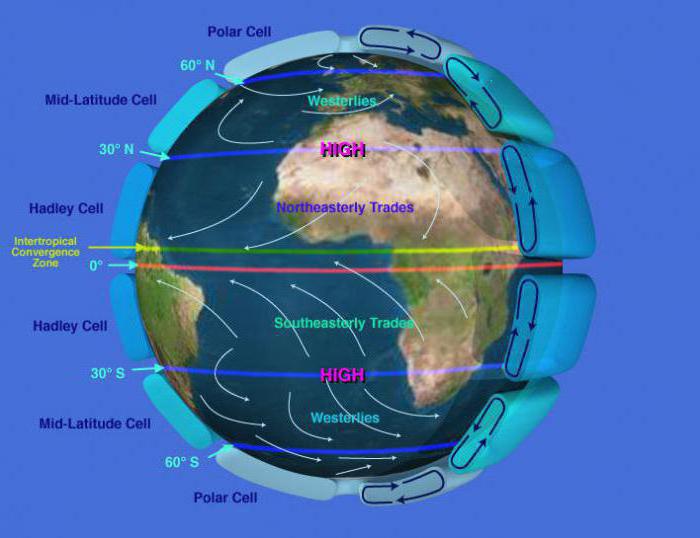
On Earth, there are 13 climatic zones. The criteria for the distribution of these belts depend on two factors: the amount of solar radiation and the prevailing air masses.
Highlights and geographical location
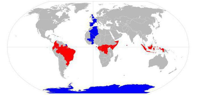
The equatorial belt is the central belt of the Earth. Located near the equator, and therefore received such a name. This belt is the only one of the 13 that tends to be interrupted, that is, it does not completely surround the Earth like other climatic zones. On both sides of the equatorial are the northern and southern hemispheres. Coordinates: from 5 ° —8 ° s. sh. to 4 ° —11 ° S. sh.
Regional division
The equatorial belt is considered constant (main) - this means that throughout the year the territory does not change the weather and climate, the dominant air masses are the same - equatorial. This easily explains. geographical position. The equatorial belt refers to three regions in which a special, unchanging climate is established:
- Continent South America within
- Mainland Africa: its equatorial part and
- A large territory and the nearest water area of the Great Sunda Islands.
Climate basics
The climatic conditions of this belt are the same. They are characterized by:
- constantly high temperatures;
- single season of the year (summer);
- abundant precipitation (the highest rates on the planet);
- the predominance of equatorial which are affected by geographical location;
- characterized by high humidity;
- weak, short winds;
- the widest variety of flora and fauna representatives;
- unfavorable conditions for human habitation.
Climatic features
The average monthly temperatures of the equatorial belt vary within + 24 ° ... + 28 ° C. This constant figure is due to the equally high position of the Sun relative to the equator. It is for this reason that changes of the seasons are imperceptible here, and the difference in lowering and increasing temperatures is only 2 ° C (the lowest figure on Earth). The radiation balance of the region is 70-90 kcal / cm 2 per year. In the oceans, it rises to 120 kcal / cm 2 per year. In this region, they are calm, they are characterized by calm. Atmospheric pressure of the equatorial belt is low.
Tropical trade winds are acting on this region on both sides of the equator, creating here a constant supply of moist air. Relative humidity in this zone varies between 80-95%. These two reasons (humidity and high temperatures) cause afternoon showers in the territories. The average annual rainfall in the equatorial belt is 2,000–3,000 mm (on the slopes of the mountains, this figure rises to 10,000 mm / year), which makes these regions the most humidified on the planet. Increased humidity occurs due to the predominance of precipitation over evaporation (per 1,000 mm). They condense in the lower troposphere. ![]()
Features of the relief and soil
In the equatorial belt, geomorphological processes are particularly intensively distinguished. A striking example is the equatorial belt of Africa. For the region, a common feature is a powerful weathering crust:
- lateral erosion is characteristic of lowland areas;
- river valleys are wide, flooded flood plains;
- in mountainous areas, river valleys, on the contrary, are narrow and deep;
- there are often landslides.
The soils of the region are acidic, ferralitic. They are poor, the humus content is no more than 3%, and when plowing or cutting down forests, they lose fertility over time.
The features of the equatorial belt are the presence of a wide and powerful hydrological system. It is within this region that the most affluent river of the planet - the Amazon - is located.
Vegetable world
The climate of the belt creates ideal conditions for the growth of evergreen equatorial forests of high humidity. Such a forest is called Gilea (in South america - it is selva, or “rain forest”). These plantings are characterized by a long history, the widest biodiversity, a large number of endemics. More than half of all plants and animals of the planet live and grow in the gileyas, it is believed that thousands of species remain unidentified. The features of the equatorial belt are that wet forests consist of several tiers. The topmost are trees. They have a high even trunk, horizontal rhizome. The middle tier is represented by lianovas. Also, you can often find useful (production and economic) species - cocoa, rubber, plants with colored wood. 
Animal world
The equatorial belt of the Earth is a unique place for the life of various representatives of the fauna. They are presented here a huge number of species. Most of them have adapted to live here in the trees and their crowns. A large number of monkeys, sloths, anteaters, capuchins, tree porcupines, langurs, opossums, bats, lizards, frogs and snakes are found on the territory. Of land animals, rhinos, hippos, elephants, and tapirs are common. Of the predators - only representatives of the cat - leopards and jaguars, which are also adapted for life in the trees. In addition, equatorial forests are an ideal place to live for a variety of birds and insects. Their characteristic feature in the region is that they all have a bright, “poisonous” color.
Environmental problems
The Earth's equatorial belt is currently undergoing strong interference from humanity. And this leads to inevitable environmental changes. And it is worth noting that not for the better. It is a well-known fact that forests are “light” planets. The greatest proportion of themselves take exactly equatorial wetlands. But in recent years there have been catastrophic changes in the territorial composition of forests. They are anthropogenic in nature. Most of marginal trees are cut down, many species of animals are exterminated. Some of the felled forests are replaced by coffee or other plantations.
Conditions for a person
However, despite all the suitable factors for living and spreading here representatives of flora and fauna, the equatorial belt is extremely unfavorable for people living here. This, of course, is influenced by its geographical location. The equatorial belt is characterized by high humidity and constant hot temperatures. And these factors, in turn, have negative influence on human health. In addition, these conditions are ideal for the formation of natural foci of dangerous infections. Also in the equatorial belt is found a huge number of poisonous insects, animals and plants. 
Equatorial belt countries
Nevertheless, the territory of some countries falls on the equatorial climate zone. In South America, this region covers the eastern part of Brazil, Ecuador, Uganda. In Africa these are the countries of Congo, Gabon, Kenya. In the island part - Sunda Islands, about. New Guinea, oh. Sri Lanka and the Malacca Peninsula (Indonesia).
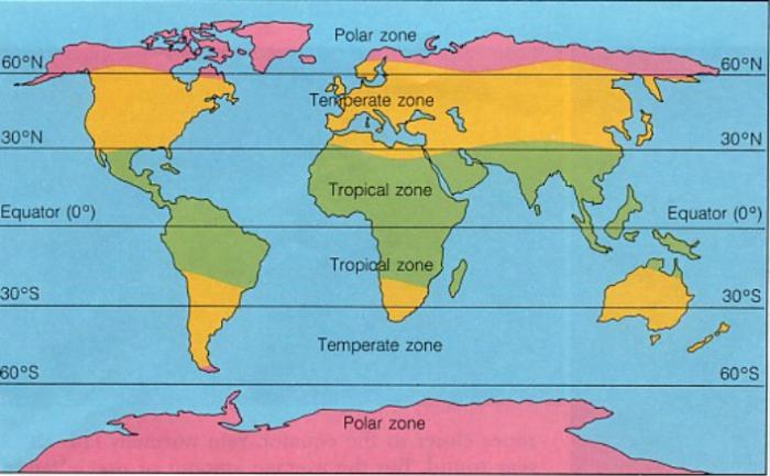
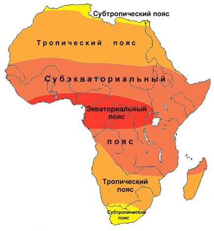
Africa almost in the middle crosses the equator, therefore in its northern and southern parts climatic zones, with the exception of the equatorial, are repeated (Fig. 61). Stand out two subequatorial, two tropical and two subtropical belts.
Equatorial belt covers a narrow coastal strip along the Gulf of Guinea and the Congo Basin. In this belt, warm and humid equatorial air masses prevail throughout the year, so there is one type of climate here - equatorial. The temperature throughout the year is high and reaches +26 ... 28 ° С. The total annual rainfall is over 2000 mm, and they are distributed evenly throughout the year.
Subequatorial climatic zones with their characteristic subequatorial climate located on both sides from the equatorial belt, approximately to a latitude of 15-20 °. Here, during the year, there is also a high temperature (+25 ... 28 ° С), but the alternation of summer wet and winter dry periods is clearly visible. This is due to changes in air mass types depending on the seasons. In summer, the equatorial humid air mass prevails here, in winter - dry tropical air.
Climate on both sides of the equator. In the annual cycle of subequatorial belts there are two rain periods. Local residents call them "long rains" and "short rains." They are separated by two dry winter periods. To the north and south of the equator, dry periods are lengthened, precipitation decreases and becomes less and less regular. The annual amount of precipitation indicated on the map, in fact, does not really correspond to reality, because a place that according to reports receives 380 mm. annual precipitationIt can be achieved for several years.
Tropical Belts occupy the largest area on the mainland. During the year, the continental tropical airway dominates here. Under her influence in the Sahara, as well as in South Africa, an area tropical continental (desert) climate type.
The Sahara is located in the zone of downward movements of the air and the dry trade winds of the Northern Hemisphere. This is mainly due to non-significant rainfall and low relative humidity. The sky here is mostly cloudless, but its color is almost never transparent blue, as the smallest dust hangs in the air. Precipitation is extremely irregular. It happens that for several years not a single drop of rain reaches the surface of the earth. High daytime and low night-time air temperatures, as well as its considerable dryness, as well as dust storms negatively affect a person’s stay in the desert.
In the Sahara, the wind wakes up and goes to bed together with the sun. Winds play a significant role in the life of the desert. Here, on average, out of 100 days, only six are windless. Hot winds in the north of the Sahara have a bad glory. They blow from the center of the desert and can destroy the crop for several hours. Strong winds (samums) cause dust and sand storms. Wind speed during a storm reaches 50 m / s. In the air rises a mass of sand and small pebbles. Storms begin and abate suddenly, leaving behind them clouds of dry, slowly settling dust "fog".
An area is formed in southeastern Africa tropical humid climate with a lot of precipitation throughout the year. Material from the site
The far north and south of Africa are located in subtropical climatic belts. The average annual temperature here is about 20 ° C heat, but it varies considerably over the seasons. Depending on the amount of precipitation in the subtropical zones, two climatic areas. In the north and southwest of Africa the region dominates mediterranean climate (characteristic of the coast of the Mediterranean Sea, hence the name). Precipitation in this area falls mostly in winter, summer, on the contrary, is dry. (Recall how this is explained.) In the southeast of the continent, the region dominates. subtropical humid climate with uniform moistening. Under the influence of the trade winds, the precipitation here is distributed more or less evenly throughout the year.
- Africa is located in equatorial, subequatorial, tropical and subtropical climatic zones.
- In the equatorial and subequatorial climatic zones, one type of climate prevails.
- In the tropical climate zone there are tropical continental and tropical humid, and in the subtropical zone - Mediterranean and subtropical humid climate types.
This page contains material on topics:
The location of the subtropical zone in Africa
Climatic features of the tropical belt of Africa wind in summer
Africa's tropical desert climate areas
Comparison of the climate of the equatorial and tropical belts of Africa grade 7
-
The widest part of Africa is located in the center of the hottest light belt. The whole continent is caressed by the sun all year, receives a huge amount of energy of our star. The climate of Africa is determined by geographical location, air circulation, the influence of the oceans, the nature of the underlying surface. By a combination of these main factors on the mainland, climatic zones (main and transitional) are distinguished: subtropical, tropical, subequatorial and equatorial. In this order, they are replaced in the northern hemisphere from north to south.
General characteristics of Africa’s climate
The equator crosses the continent around the center. The northern part, a larger part of the continent, extends to the Mediterranean Sea in the north and the Arabian Peninsula of Eurasia in the northeast. To the south of the equator lies the narrow part of Africa, resembling a triangle in shape. The area from the equator to the tropic gets about 200 kcal / cm2 per year. The average for total solar radiation on the mainland is 160 kcal / cm2 per year.
The climate of Africa is diverse, heat and moisture are unevenly distributed, especially in desert regions. The maximum amount of precipitation is obtained by the southwestern foot of the volcano Cameroon - up to 10,000 mm / year. Africa is superior to other continents in temperature indicators, is the hottest of them. The greatest amount of solar heat falls on the land mass located between the Northern and Southern Tropics.
We will describe the climate of Africa on the position of the continent’s territories relative to the equator. This is the main climate-forming factor on which the heating of the earth's surface depends, and on it the air. An important role belongs to other conditions: atmospheric circulation, the nature of the relief, the characteristics of the underlying surface, the position relative to other continents, oceans. The main and transitional types of climate in Africa:
- Equatorial.
- Subequatorial (wet in the south, arid - in the north).
- Tropical desert.
- Subtropical Mediterranean.
Equatorial climate of Africa
In the center of the continent near the parallel 0 ° a hot and humid climate is formed. The equatorial belt covers an area of 6 °. sh. to 5 ° S sh. in the basin of the Congo in the east, on the coast of the Gulf of Guinea reaches 8 °. sh. The conditions of this region are determined by equatorial air masses — hot and humid; it rains throughout the year. The air in January, July, heats up on average to +25 ° C, and 2000-3000 mm of precipitation falls annually. The coefficient of moisture reaches 1.5-2 (excess).

Evergreen forests
The equatorial climate of Africa creates favorable conditions for heat and moisture-loving plants. Equatorial region of Africa is covered with dense evergreen forests - giley. It is difficult for animals and people to be under the forest canopy, where it is dim and stuffy, the air is saturated with smells of burning waste and the scent of orchids.
An impassable sparsely populated natural area has been intensively developed in recent years. Forest felling is carried out for the purpose of obtaining valuable timber for export. Mahogany, abashi (African maple) and other species are mined.
Subequatorial climate zone
It occupies the vast expanses of the continent from 20 ° S. sh. to 17 ° c. sh. In areas of subequatorial climate, more than 1/3 of Africa is located. In the eastern part the transitional belt is not interrupted by the equatorial, in the southern hemisphere it does not reach the Atlantic Ocean.

Characteristics of Africa’s climate in the subequatorial region of the continent:
- Temperature conditions and humidification are determined by the alternating effects of tropical and equatorial air masses. As a result, the seasons are formed - wet and dry.
- In the summer, hot and humid air of equatorial latitudes prevails, in winter comes a dry tropical air mass, it becomes a little cooler.
- The duration of the season without precipitation is from 2 to 10 months. The average annual air temperature is above +20 ° С, precipitation will fall around 1000 mm / year (in the southern part of the belt).
- The duration of the wet period and the average annual precipitation decrease to the margins of the subequatorial belt.
- In the northern areas of rain falls less, there is a hot breath of the desert. The hottest period of the year is at the beginning of the rainy season, when the average monthly temperature exceeds the mark of +30 ° C.
- For the cool months of the wet period, temperatures of about +20 ° C and higher are typical.
Savannah
In addition to geographical location and atmospheric circulation, the climate features of Africa are determined by characteristic feature relief of the mainland. The outskirts of the continent raised; in comparison with the internal regions, they are located above the sea level.

Mountain ranges and massifs in the north, east, and southeast limit the influence of the Indian and Atlantic oceans on the climate of the savanna zone, stretching within the subequatorial belt. The characteristics of flora and fauna in this part of the continent are determined by the alternation of the wet and dry season, the lack of moisture for the formation of full-fledged forests, full-flowing channels.
Tropical Belt
The climatic features of Africa in the Northern and Southern Tropics are the dominance of hot and dry air masses. Areas with arid tropical climate, with a significant daily amplitude of temperatures, extend in the north and south of the continent to the 30th parallel. A large part of the continent is affected by arid tropical climate. In this belt, the highest monthly average indicators are noted: + 35 ... 40 ° С.
The array of North Africa receives a lot of solar radiation and extremely little moisture. Daytime air temperature rarely drops below 20 ° C. Snow lies on the mountain tops in the tropics, desert and semi-desert areas lie at the foot. The most extensive lifeless areas: in the north - the Sahara, in the south - Namib.

Deserts and semi-deserts
In the Sahara there are areas where the temperature minima and maximums were recorded (-3 and +58 ° C). Temperature during the day on hot sand and stones reaches + 60 ... 70 ° С, at night it can drop to +10 ° С. Daily temperature fluctuations reach 50 ° C.
Precipitation in the deserts of Africa falls from 0 to 100 mm / year, which is extremely small. Sometimes rains do not reach the surface of the earth - they dry out in the air. Moisturizing lean, Kuvl. = 0.1-0.3. The life of the desert population is concentrated in oases - groundwater outflow areas. Agriculture, cattle breeding, tourist services are developed.
Subtropical Africa
The extreme south and a narrow strip of the northern coast are occupied by areas of subtropical climate. This is a transitional belt, the features of which are determined by the properties of air masses of temperate and tropical latitudes. The dry and rainy seasons are characteristic of the subtropical climate, as well as a significant moisture supply, which contributes to the development of agriculture. The maximum number of rains in the northwestern and southwestern regions of the African continent is in the winter months, and in the southeast, the rainy season is summer.

Subtropical Africa and other areas of the mainland attract many tourists. The world famous resorts are located on the shores of the Mediterranean and Red Seas, the Indian and Atlantic Oceans. The main direction of tourism development and types of recreation in North Africa - beach, sightseeing. In the savannas - safaris, jeeping. Less visited areas are impassable wet forests and uninhabited desert areas.
What is the climate in Africa now and in the past? The answer to this question lies in the channels of the dry rivers (wadi), the ruins of the once thriving cities, covered with sands of the Sahara. Africa’s climate is aridized; deserts are advancing in the north and south. A striking contrast to this phenomenon is floods, when rivers overflow and coastal areas. Scientists suggest that catastrophic natural processes may be associated with intensive logging of tree plantations, the widespread construction of cities, roads, the development of agriculture and cattle breeding.
Equatorial belt. The equatorial lighting belt is the longest on Earth: it surrounds it in a large circle. The geographical, or landscape, equatorial land belt occupies a small area, as the ocean dominates in these latitudes: the length of the middle parallel of the belt - equator over the ocean is 30,800 km, and overland only 9200. Due to the inclination of the Earth’s axis of rotation to the ecliptic from south of the geographic equator, zones of variable atmospheric circulation closely approach, cutting off large areas from the equatorial belt to the subequatorial one.
The most typical nature of the equatorial belt (powerful evergreen constantly wet forests - giley) is expressed in those parts of continents where air masses rise along the relief. Humid equatorial forests occupy the largest territory in South America — the entire Western part of the Amazon lowland and the slopes of the Andes — and reach the Brazilian and Guiana highlands already in subequatorial latitudes. This is due to the overall humidity of the climate of South America, and the rise of moist air at the approach to the Andes.
In Africa, despite its position on both sides of the equator, the area of gilles is small — from the Gulf of Guinea to the upper Congo, between 5 and 6 ° S. sh. and c. sh. It is compressed by dry trade winds.
In Asia, rainforests occupy Indonesia and Malacca and extend northward to the slopes of the Himalayas (up to 30 ° N), due to the peculiarities of the monsoon circulation (see above) and the relief of South Asia.
Two main types of landscapes predominate in Guiley: a) forest flooded and marshy and b) forest non-flooded. At the periphery of the equatorial belt, forests are deciduous-evergreen, transitional to subequatorial.
Subequatorial belts. They are two: one in the north, the other in the southern hemispheres. The northern stretches 120 ° from west to east and from 5 to 25 ° from north to south. It includes the Isthmus of Panama, the Guiana Highlands and the eastern part of the Amazonian Lowland, Africa from the Niger Basin to the headwaters of the Nile, Somalia, Hindustan, Indochina and the Philippines. In the southern hemisphere, the corresponding belt is smaller. It goes south only to 20 ° S. w., and in longitude extends to 80 °; it contains the Brazilian Highlands, Central Africa (the Zambezi and Great Lakes Basin) and Northern Australia.
The most significant feature of the subequatorial belts is the variable atmospheric circulation, which consists in the seasonal latitudinal migration of the equatorial minimum and, accordingly, the change of humid equatorial air by dry tropical weather, in the presence of the rainy season and the dry season. This is due to the pronounced seasonal rhythm of all processes.
In the subequatorial belt two natural areas: a) subequatorial forests and b) savannas.
Subequatorial forestsin the form of a narrow zone adjacent to the gile. They are alternately wet and deciduous.
For zone type savanna landscapecharacteristic combination of plots with a grassy cover with individual trees, groups of trees, small forests or thickets of bushes.
Depending on the duration of the dry period, the savanna zone is divided into three subzones: 1) wet savanna and savanna forests,located near the belt of gilies; 2) dry savannas with woodlands or individual trees,occupies the middle zone of the belt; 3) desert savannas and shrubs,adjacent to areas of tropical deserts.
Typical savanna continent - Africa. Even at the equator in East Africa there are no gilias and the nature is subequatorial. This is due to the proximity of Arabia, due to which the northern monsoon is dry.
In South America, there are savannahs in the Brazilian Highlands, in the Orenok and Eastern parts of the Amazon lowland. Here they are due to the dependence of moisture circulation on the relief.
In Asia, savannas occupy a small area and are not typical, since even the southern peninsulas lie in tropical, rather than subequatorial, latitudes. Due to the monsoon circulation and the mountain belt of the Himalayas, their nature is not desert, but subequatorial. Moreover, since Hindustan and Indochina go into the ocean, they are not as arid as typical savannas, and sparse forests grow on them, and even wet forests on the slopes of the Ghat.
The landscape of mangroves is typical for the whole hot belt. They are common on low tidal seas. Mangroves are represented by evergreen shrubs or forests of extremely characteristic shape - with curved trunks, with stilted and respiratory roots.
Considerable areas of savanna are mastered.
In the ocean, subequatorial belts are expressed by the trade-wind currents.
Tropical belts. Tropical belts are the latitudes of hot and usually dry air dominated both on the continents and on the oceans, forming in tropical anticyclones. The descending air masses give rise to the trade winds. Two planetary geographic deserts of tropical latitudes are interrupted by forest regions on the eastern shores of the continents (see the section on moisture circulation). The middle parallels of the belts are almost exactly the tropics; the symmetry of desert zones relative to astronomical tropical circles proves the conditionality of their position by the inclination of the axis of rotation of the Earth. The change in Coriolis force in tropical latitudes caused the concentration of baric maxima here. Desert belts, therefore, is an infrequent phenomenon caused by separately taken factors, for example, the size of continents, and a common planetary one. The position of the continents is explained only by the west-east asymmetry of the belt.
The northern tropical belt on the continents extends from 10 °. sh. at the Gulf of Aden to 34 °. sh. in the upper Indus basin - at 24 ° from north to south and at 120 ° from west to east. Southern, since the continents to the south are wedged out, somewhat less. Its southern boundary coincides everywhere with 30 ° S. w., North in Africa reaches 16 ° S. w .; belt width 14 °, length on land 85 °.
The seasons of the year in the northern and southern belts are anti-chronical (opposite in time).
Throughout the continent, the desert zone stretches only in North Africa; moreover, it extends into Arabia and after a break into the Indus basin (Thar desert). In this case, the dependence of the area of deserts on the proximity of Africa and Asia and the continentality of the northern half of the eastern hemisphere is obvious.
Inside the desert continents there is still in Australia. In both Americas and South Africa, deserts are confined to the western shores only (California, Atacama, and the semi-desert Kalahari).
Such large differences in the position of desert regions, as well as differences in the nature of deserts are explained by variations in the ocean-atmosphere-continent interaction: a) the magnitude and intensity of cold currents along the western shores, b) the size, configuration and relief of the continents, c) caused by these atmospheric circulation features .
On the eastern shores of the continents in the tropical belt, moistened by air masses of the eastern transfer, in Yucatan and Florida, on the coast of Brazil, in Madagascar, on the York Peninsula and in East Asia, there are regions of tropical rainforests, turning into continental wet deciduous, and then in the savannah.
On the ocean, tropical zones in both hemispheres are very distinct. Tropical air and anticyclones dominate here. They correspond to increased salinity, low fertility and high transparency of water, and a system of circular currents.
Subtropical belts. Subtropics are characterized by their stay in these latitudes in the summer of tropical, in the winter of moderate air. These are not transitive, but independent belts. Their geographical position is determined by the inclination of the axis of rotation of the Earth (zone of variable circulation), as well as the magnitude of the Coriolis force (the shift of anticyclones to tropical latitudes).
The location of regions of subtropical nature, the particular climate and landscapes of each of them also depend on the relief of the continents - the lithogenic basis for the development of landscapes and interaction in the ocean – atmosphere – continent system.
The average parallel of subtropical belts is 35 ° c. sh. and y. sh. These are the axes of the inland belts of the crustal fault in both hemispheres.
The northern subtropical zone includes North Africa, southern peninsular Europe, Western Asia, the Southern Crimea, the Caucasus, the south of Central and parts of Central Asia, Central China and southern Japan. In the Old World, it stretches 133 ° longitude. In North America, subtropics extend from the peninsula of California and San Francisco to northern Florida and the southeastern United States at 45 ° longitude.
Most northern limits subtropical belt lie at 46 ° s. sh. on the Balkan coast of the Adriatic Sea; the most southern ones are in California and in Central China, where it approaches the tropic.
The southern subtropical belt on land is incomparably smaller than the northern one. It extends only by 76 ° in longitude in relatively small arrays: Chile and Argentina between 35 and southern Africa, southern Australia. The southern zone is located on the southern outskirts of the continents and cannot be considered as inland.
A long stretch of land in longitude determines the formation of three types of regions: western, central and eastern. In the southern hemisphere, where the land mass is smaller, there are no inland regions.
In the western regions with a Mediterranean climate, natural zonal landscapes are represented by hard-leaved subtropical forests and maquis thickets, often secondary. On large African-European-Asian land, this zone extends from Gibraltar to West Asia.
In America, by the Cordillera and the Andes, it is pressed to the Pacific Ocean and is expressed in small regions around San Francisco and Santiago.
In South Africa and Australia, the territory with Mediterranean nature is small, since the continents end at 35 ° S. sh.
In the central parts of the continents, where the air masses of the western transport penetrate weakly, there are areas of the continental subtropical climate known as dry subtropics:Anatolia, Iran, Iraq, the Kura basin, the south of the Central Asian republics, the southern states of the Midwest USA and the north of Mexico, Argentina south of lower Paraná, the interior regions of South Africa and the south of Australia.
The climate of dry subtropics is a more arid variety of the Mediterranean. The sharply crossed relief of the fault belt creates diversity in the distribution of precipitation and heat. Leaving aside the details of this mosaic, the whole area can be divided into three parts: the mountain slopes, the foot and the plains.
The landscapes of the steppes, dry steppes, semi-deserts and deserts are common on the plains. In the foothills are characteristic shrubs and light forests. In the mountains, a vertical belt appears.
Subtropical and partly tropical countries - the birthplace of agriculture, which at first was only irrigated - Mesopotamia, Egypt, India, China, etc.
On the eastern shores of the continents of the subtropical zone, the climate is monsoonal; this wet subtropics:Middle China, South Japan, Southeast USA, Uruguay and neighboring territories of Brazil and Argentina, Southeast Africa, Southeast Australia in the Sydney region. The climate of the humid subtropics of Transcaucasia - the Colchis Lowland and Batumi is close to this.
The natural landscape of humid subtropics - constantly wet mixed forests. They are almost everywhere replaced by man-made landscapes, mainly fields.
In South Africa and Australia, landscapes of humid subtropics are bounded in the south by the coast, in the north by mountains. The regions of humid subtropics influenced by cold monsoons in Asia, the Antarctic winds in South America and the Labrador Current in North America are shifted towards the tropics.
Northern temperate belt. In the mid-latitudes of the globe, the lithosphere is antisymmetric with respect to the equatorial plane: a huge oceanic ring corresponds to the huge continents of the northern hemisphere in the southern one.
The northern temperate belt on land extends from Ireland to Kamchatka by 175 ° and from Alaska to Newfoundland by 100 °, in total, thus, by 275 ° longitude.
Its width along the meridian is more than 1/3 of the whole hemisphere. The southernmost point lies in North China at 33 °. w., and the northernmost on the Scandinavian Peninsula, almost 70 ° C. w .; the length of the meridian is 37 °. The influence of the Gulf Stream in Europe and the winter monsoon and Kuroshio in Asia is evident. In the southern hemisphere, only the southern tip of America, half of Tasmania and part of the South Island of New Zealand enter temperate latitudes.
The northern temperate zone is characterized by the greatest variety of zonal landscapes for the Earth. In the northern part of it, the taiga enters the Taimyr forest tundra, and in the southern temperate deserts of Central Asia they border on subtropical ones. The mode of heat and moisture, all components of natural areas are so different that it makes sense to divide this belt into two: 1) moderate and 2) boreal.
The first includes zones desert, semi-desert, steppe, forest-steppeand mixed forestsin the mainland sectors of Eurasia and North America and deciduous forestsin the ocean.
The boreal belt coincides with the zone of coniferous forests, or taiga; this can be attributed forest-tundra, because it is rather a transition zone.
The difference between the temperate and boreal belts is quite deep. In the first, atmospheric humidification varies from sufficient to scarce and the differentiation into zones is caused precisely by the magnitude of humidification, taken, of course, in comparison with heat; in the second, moisture everywhere excessive and decisive in the formation of zones is the amount of heat.
The boundary between the belts is indicated by the transition from gray forest soils in mixed forests and chernozem in the steppes to podzolic soils in the taiga zone. The soil cover quite clearly reflects the nature of the zones and belts.
In the oceanic sectors of the moderately warm belt is zone of deciduous forests.In Europe, it extends from Denmark to the Pyrenees and from Ireland to Belarus. To the north and east, the deciduous forests turn into mixed coniferous and deciduous. After a huge break in the mainland sector broadleafand mixed foreststhey reappear in the Far East in the middle course of the Amur River; they go to the north almost to 50 ° C. w., and in the south gradually moving to subtropical.
In North America zoneconstantly wet broadleafand moderately wet mixed forestsoccupies the United States and Canada, the Great Lakes region, the Appalachians and the Ohio basin.
The landscapes of the Far Eastern and American regions differ from European ones by the richness of the species composition of forests. This difference is explained by their development history in the Pleistocene. The forests of Europe, sandwiched between the continental ice sheet and the mountains of the alpine belt, died from the cold, while the American and East Asian forests migrated south and avoided the disastrous effects of the Pleistocene glaciation, although in America the ice cap reached Ohio.
The spectrum of zones and landscapes is incomparably greater in the mainland sectors of the temperate zone than in the near-oceanic ones: deserts, semi-deserts, dry steppes, steppes, forest-steppeand mixedand in Siberia small-leaved forests.
In the most arid regions - in Central and Central Asia, in Kazakhstan and in the Great Basin - subtropical semi-deserts and deserts are moving into moderate, extending to the northern shores of the Caspian Sea, Aral and Balkhash in Eurasia and the Colorado River in America.
In contrast to tropical deserts in temperate in their natural state, almost the entire surface is fixed with vegetation cover. Fluttering sands - a temporary education, usually obliged to immoderate grazing. In the middle part of the zone, in the area of distribution of alluvial sand, the desert is saxaul and shrub. In the north, in the transition to the semi-desert zone, a subzone of wormwood and solyanka deserts is located. Stony deserts with their rubbly or pebbly surface are almost devoid of vegetation. In Central Asia, such deserts are few; there are more of them in Central Asia and in the Great Basin.
In the river valleys meadow landscapesand tugai forests.
As the heat balance decreases, and mainly as the atmospheric moistening of the desert increases through a narrow strip dry steppesgo into wide steppe zonein Eurasia and prairiein America.
The zone of the steppes of the temperate zone begins in the Mid-Danube Lowland and extends to Transbaikalia and Mongolia. In North America, the prairie zone is located east of the Cordillera.
The most significant feature of the nature of the steppe zone is considered to be insufficient (from 90 to 60%) atmospheric humidification. The lack of moisture is due to the forestlessness of the watersheds and, consequently, the predominance of the grassy, mainly grass vegetation in its natural state. He also determines the type of soil formation: chernozems are formed here - the most fertile soils on Earth.
At present, almost all the steppes, with the exception of the reserves, are plowed up. However, the use of steppes for agricultural purposes depends on their natural genetic basis.
The steppe zone of North America — the prairies — in the west is bounded by the Cordillera. Its width is greater than the length. Often this position of the zone is mistakenly regarded as its elongation from north to south.
With the approach of moisture to 90 and 100% of the steppe are replaced forest-steppe.The northern boundary of the forest-steppe approximately coincides with the isotherm of 20 °, the southern with 22 ° C of July. The main difference between the forest-steppe zone and the steppe zone is in the circulation of the atmosphere: the forest-steppe are already in the field of cyclonic activity not only in winter but also in summer.
In the forest-steppe zone, steppe landscapes alternate with forest. The zone is divided into two regions: western or European, and eastern, or Siberian.
South temperate beltthe mega-relief is antisymmetric to the north: it is almost entirely located on the ocean. The land area in it is negligible. Only on the western coast of the Andes, the open sea air masses of the western transport and cyclones, the near-ocean constantly wet forests grow. In the east, in Patagonia, it is accepted to call the landscape “steppe”, although, in essence, it is heathland. In Southern Tasmania, the relief is mountainous, forest landscape. The landscapes of the South Island of New Zealand repeat the Chilean-Patagonian: in the south-west a deciduous forest grows in a small area, in the east - grasses phytocenoses.
Northern boreal belt. In the northern part of the middle latitudes on the vast expanses of Eurasia and North America extends the most extensive area on Earth - coniferous forest areasiberian name taiga.Its southern boundary at the Upper Lake reaches 47 °. w., and the north on the Kola Peninsula rises to 68 °. sh. Further to the north - to Lake Taymyr (near 75 ° N lat.) Extends tundra zone.
The hydrothermal conditions of the boreal belt are characterized by a decrease in the annual amount of solar heat to the limits excluding the growth of first broadleaf (the southern border of the belt approximately coincides with July isotherm 18 ° C) and then conifers (July 10 ° C isotherm at the northern border of the belt - seed ripening trees).
Atmospheric moistening becomes excessive - from 100 to 140%. Glacial deposits and morphosculpture relief are young everywhere. The climate and topography determined the density and high water level of rivers, the abundance of lakes and the swampiness of large areas.
The abundance of precipitation determines the proluvial regime of soils, during which podzols develop; they are not fertile.
The ice cover and the cold climate of the Pleistocene destroyed the former vegetation; therefore, modern flora is poor in species.
In the boreal belt, there are three main landscapes: 1) coniferous forests2) marshand 3) flood meadows.Frequently secondary small-leaved forests and dry meadows.
In Eurasia coniferous forest zoneextends from the western shores of the Scandinavian Peninsula to the eastern shores of Kamchatka. On the western slope of the Scandinavian Mountains and in Scotland coniferous forests of spruce and pine, turning into small-leaved birch-aspen above. The European dark coniferous taiga extends from the eastern slope of the Scandinavian Mountains to the Urals.
Depending on the soil, topography and soil moisture, coniferous forests form landscape types of forest plantations: a) spruce forests of various species, b) pine forests, or burs, also diverse, c) secondary small-leaved forests - birch and aspen forests. In Western Siberia there are also forests of fir, larch and cedar pine.
In Eastern Siberia, light-colored sparse forests of dahurian larch dominate on ever-frozen ground, and stone birch dominates on Kamchatka.
In Canada, the dark-coniferous taiga zone stretches from Newfoundland and Nova Scotia through the Great Lakes basins to the southern half of Alaska and the Cordillera. Here, northern coniferous forests gradually become subtropical Californian rich floristic composition.
In the taiga zone, the indispensable and characteristic type terrain make up the marshes. Swampthe area on which a special vegetation cover has been formed under the influence of excess water is called, a layer of peat has accumulated at a depth of at least 30 cm; soil formation proceeds along the marsh type, their animals have settled and a specific microclimate has formed. The formation of swamps occurs in two ways: a) the swamping of watersheds and b) the swamping of lakes, oxbows, floodplains and other lowlands.
When water-logging arrays are swamped on over-wetted soil, green mosses are the first to settle, especially cuckoo flax. His dead remains accumulate, and the surface of the swamp gradually rises. When it reaches such a height, to which the groundwater is no longer rising, the bog enters the stage of only atmospheric oligotrophic feeding. Under these conditions, sphagnum moss settles. As a result of the accumulation of peat, watershed swamps become convex or upland. Their surface can rise 6-10 m above the surrounding non-scorching area.
The main type of terrain of the coniferous forest zone is meadows. By the meadowis a territory with grassy vegetation, with an average degree of moisture (in the steppes it is insufficient, and in the swamps excessive) and with soddy soils. Meadows in the forest zone are of two types: flood, or floodplain, and dry valley.
Northern cold subarctic or subpolar belt. It occupies the northern periphery of Eurasia and America. Its southern boundary follows the coastline and also depends on warm and cold ocean currents. In Scandinavia, thanks to the Nordkapp warm current, the cold belt is narrow and located to the north of the polar circle. In the middle of the continent, on the Taimyr Peninsula and on the Lena, the southern boundary of the belt rises to 72 °. sh. In Northeast Asia, near the shores of the cold Sea of Okhotsk, it descends south of 60 °, and in the Hudson Bay Basin even reaches 50 °. sh., to the latitude of the English Channel and Kiev.
Sun heat is not enough. The southern boundary of the belt corresponds approximately to the isotherm of 10 °, and the northern boundary to 0 ° C of July. Already at a shallow depth (about 30 cm), the soil is grasped by permafrost. There is little precipitation - from 300 to 100 mm, evaporation is even less, atmospheric moisture is excessive - up to 150%.
Under these conditions, tree plantations cannot grow; tundra landscapes are typical. Tundrais called a complex of treeless moss, moss-shrub and lichen formations that have adapted to the climatic and soil pessimum. On the northern limits, the soil and tundra landscapes are formed only by spots; this is the polar desert.
In the tundra zone there are three types of landscapes: tundra, marsh and floodplain meadows.
The first and most typical landscape for the zone is shrub tundra.
The second type of landscapes tundra zone - swamps.In the valleys of large rivers are floodplain meadows.
On the Aleutian and Commander Islands and the Peninsula, the tundra fishermen are represented by the marine species - subarctic meadowswith thickets of willow, passing with height into heathland, and then into the loach.
Southern Boreal Belt. In the southern hemisphere in the subpolar latitudes, the ocean reigns supreme. Tundra landscapes are found sporadically on rarely scattered islands and do not form zones. On the Falkland Islands (51–52 ° S), there is stony lichen tundra with thickets of birch and willow; South Georgia (54-55 ° S. Sh.) Lies on the border of the Antarctic ice zone.
Polar belts, or belts of eternal frost. The northern and southern polar belts are opposite in their mega-relief - the first continental, the second - oceanic. However, their climates have many common features.
On land of the Arctic belt, three types of landscapes are distinguished: 1) island glaciers, 2) polar deserts (on Wrangel Islands, Novosibirsk, Severnaya Zemlya and the Canadian Archipelago) and 3) Arctic tundras, usually spotted on the border with the tundra zone.
In Antarctica, almost solid mainland ice, among which there are about 20 oases. They are located either on the coast or on the Antarctic Peninsula. The area of the largest of them, located on Victoria Land, is 4000 km 2. The area of others is from 500 to 6 km 2 and less. Antarctic oases are areas of exposed rock. Their total area, according to E. Korotkevich, is about 30-40 thousand km 2. Oases are formed there, where the influx of ice is difficult. The cause of their occurrence is a sharp decrease in the albedo on the dark surface of rocks compared to ice.
Altitude Zoning. In mountainous countries, as already mentioned, horizontal natural land zones are replaced by high-altitude belts, and on elevations, landscapes vary within two adjacent zones.
The altitudinal zonality in the mountains is due to a drop in the temperature of the air and an increase in the amount of precipitation and atmospheric humidification. In the most general terms, vertical climatic changes are similar to zonal, but not identical to them. The intensity of solar radiation increases with height in the mountains, and decreases in the direction from the equator to the poles. The atmospheric pressure in the mountains decreases consistently and monotonously, whereas between the equator and the poles there are zones of baric maxima and minima. In the horizontal direction, the humid and arid zones alternate, in the vertical, the amount of precipitation with altitude (up to 3000 m) also increases. The flow of atmospheric water and drainage of the area with the rise in the mountains increases, which is not observed as it moves to the poles. In addition, the high-altitude belts of any mountainous country, each ridge, and even its individual slopes are qualitatively individual.
Vertical zone always begins with the horizontal zone in which the mountainous country is located. Above the belt, they change as a whole in the same way as the horizontal zones, up to the area of polar snow. In this case, of course, belts fall out, similar to such zones, the conditions of which in the mountains cannot be repeated.
In the mountains of the South Island of Novaya Zemlya there are only two belts - the arctic tundra and eternal snow. With latitude, not only the number of belts changes, but also their altitude limits.
The ratio of areas attributable to different horizontal geographical areas and on the landscapes of mountainous countries, a comparison of the size of the areas of the main soil types is best, since the vegetation cover is largely altered by human activities.
Modern landscapes
Until the beginning of the 20th century, when the population of the Earth was not yet significant, and the technology was relatively simple, people’s activities were local, their nature changed in some places and natural processes, which were partially changed, were easily restored.
In the middle of the XX century. with the beginning of use atomic energy industrial activity of people has grown to global proportions and has become commensurate with the main planetary processes.
At present, people have mastered and, to varying degrees, changed landscapes on 55% of the land area, and 20% changed them radically: cities and villages were built, fields appeared on the place of forests or steppes, wetlands were drained, deserts were irrigated, the human-made bedland appeared . In 900, 70% of Europe was covered with forests, now they occupy only 25% of its area. On Earth, in general, half of the forests destroyed.
As the population grows, the economic development of the territory and the change of natural landscapes is quite natural. The transformation of large areas into economically useless ones — maquis and heathlands, moving sands, man-made badlands, etc. — has a negative value.
The landscapes created by people are called man-made, man-madeor artificial.
Solar radiation — the energetic basis of physiographic processes — remains outside of human activity. Almost not affected by the circulation of the earth's atmosphere; replacing forests with fields and creating reservoirs change it only a little. The geological base and morphostructural relief of the extraction of mineral raw materials also still varies slightly. Coastline the sea is a bit biased, only in the Netherlands and in Tokyo, houses began to be built along the coast. Consequently, the zonal-regional landscape background has remained, and only man-made landscapes are distributed within it. The clarification of this fact is important in two respects: firstly, the energy base of technogenic landscapes, the circulation of matter and energy in them remains zonal-regional; secondly, man-made landscapes are always combined with natural. The combination of natural and artificial landscapes is called modern landscapes.
Vegetation cover, animal life, soil, internal water and partly ocean, air composition and moisture circulation in the local climate (due to flow regulation, irrigation and drainage of the territory) are directly affected by people.
Changes in natural landscapes by human activities depend on three factors: a) population density; so seldom are the scattered groups of people in the Amazon river that are unable to change its nature, another thing is the modern big cities; b) the level of development of technology, the means of which even a small number of people significantly changes the landscape (with open mining, etc.); c) socio-economic conditions, from the mode of production of material goods.
The depth of changes made by people in nature, in the first approximation, can be divided into two groups: a) breaking bonds, in which people act on one or two components; b) the destruction of bonds, in which people act on all components of the landscape; while there are other links.
According to the degree of changes made by man, all landscapes can be divided into six groups:
1. Unchanged - glaciers, pristine areas of extra-tropical tropical deserts, nature reserves.
2. Weakly modified - natural meadows and pastures, water bodies, properly exploited forests.
3. Violated irrational use - secondary depleted forests, maquis, shrubs.
4. Severely disturbed and transformed into badlands — eroded, secondarily saline, secondarily marshy, waving sand, anthropogenic karst, mine workings.
5. Transformed, or cultivated, - fields, gardens, plantations irrigated and flooded, afforestation, parks.
6. Artificial - cities and villages, roads and communications, dams and reservoirs, mining.
The ratio of anthropogenic and natural landscapes shows that although people's production activity affects certain aspects of nature, and does not concern its most essential links and geographically it extends to individual lands - fields, forests, rivers, etc., the total effect of these changes is significant and already acquired a planetary character. The anthropogenic landscape does not possess self-development, is not preserved, is not restored. As soon as a person stops supporting him, he inevitably returns to the original natural.
The nature of the zones favorable for agriculture turned out to be the most changed: the steppe, forest-steppe and prairie zones are plowed up (and built up) by 70%, monsoon forests and savannas - by 40-60%
mixed and deciduous forests - by 40-50%, Mediterranean nature - by 30-40%.About 2.5 million km 2 is being irrigated on Earth, about 0.8 million km 2 have been dried. In Europe as a whole, including mountains and other areas unfavorable to agriculture, 40% of the territory has been plowed. The most productive areas - zones of deciduous forests, forest-steppe and plains of the Mediterranean - are fully developed, there are few forests and natural pastures left.
In Asia, land is almost completely plowed in two regions: a) in the steppe and forest-steppe, and b) in countries with a monsoon climate from Hindustan to Korea and Japan. On the plains of China and in the Ganges Basin plowed 80% of the area. On the plains of the arid zone - in the Front and Central Asia, in India there are centers of ancient agriculture in irrigated fields. Non-irrigated lands in the arid belt of Asia from the Bosporus and Arabia to Korea are used as pastures.
The landscapes of North America are modified in the same way as Europe. The plains of the eastern United States and Canada in the forest zone are plowed up by 60, in the prairie zone by 80%. The forests of Canada and the Cordillera are felled considerably. Subtropical USA and Mexico, tropical countries Central America mastered not only in the plains, but also in the mountains. Here, as in the Old World, are the centers of ancient culture.
In Africa there are three areas of highly modified landscapes: a) North Africa - the countries of the Atlas and the Nile Valley with ancient farming, b) Ethiopia is one of the world's centers of cultivated plants and field cultivation, c) South Africa is a modern industrial country. In the Sahara and on a larger area of the rest of Africa, with a low technical level of farming, the landscapes are only slightly modified, although animals also have to be preserved in reserves.
In South America, natural landscapes have been preserved more than anywhere else. Europeans have not yet penetrated into many regions of the Amazonia gilias. Forests cover 41% of the mainland, pastures occupy 18%. Plowed up only 9% of the total area. The occupied lands lie in the pampa of Argentina, the savannas of Brazil and on the plateaus of the Andes, which inherited the culture of the Incas.
A very peculiar change in the landscapes of Australia. 60% of the area of this continent is occupied by pastures, 90% located in savannas, light forest and bushes. It would seem that these are natural landscapes. But they widely use grass, fertilizers, plowing and even irrigation. Now that artesian basins have been found in Australia, irrigation will gradually lead to a fundamental change in landscapes, to their transformation into anthropogenic ones.
© 2015-2017 website
All rights belong to their authors. This site does not claim to be authorship, and provides free use.