The continental slope is the part of the sea or ocean floor that connects the shelf in its lower continental part and the relatively horizontal part of the bottom, or the upper edge of the ocean floor.
The continental slope can be located at different depths - from 200 meters to 4000 meters - and is characterized by a surface slope. The degree of inclination of the surface of the continental slope can be either minimal (about 4 degrees) or quite sharp (20-40 degrees). According to scientists, the continental slope occupies up to 12% of the total area of the world's oceans.
Surface and structure
The continental slope does not have an absolutely smooth surface. On the contrary, this part of the bottom is distinguished by a sharply defined relief - here you can see terraces, underwater ridges and valleys, transverse hollows, impressive canyons and pits. In the upper part of the continental slope, the process of moving large volumes of sediment downwards under the influence of gravity occurs - the formation of turbidity currents is observed. 
Scientists call these processes denudation. In the lower part there is an accumulation of particles located in the water column. The continental slope is characterized by extremely high productivity of organic matter and is classified as a special bathyal zone. And the layer of water located above the slope is usually called “batypelagic”.
The bottom of the continental slope, or benthal, deserves a separate description. It is divided into the upper part (mesobenthal) with a depth of 200-500 meters to one to two thousand meters, and the lower benthal (batibenthal) - everything that is at a depth of over one to two thousand meters.
The continental slope connects two hypsometric levels of the Earth - the ocean floor and the surface of the continent. There is a constant movement of material along the slope into the ocean depths. The upper boundary of the continental slope is clearly defined - this is the so-called “edge” of the continental shelf.
The lower boundary, where the slope meets the ocean floor, is not so distinct, because a dense layer of sediment always accumulates at the base of the continental slope. 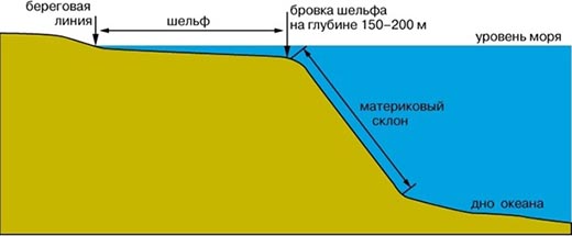
The degree of inclination of the continental slope is determined by tectonic and geological structure earth's surface.
Structure of the continental slope
Off the coast different countries continental slopes have different slopes, depths and lengths. Thus, off the coast of Australia, the depth of the continental slope is almost five kilometers, with a width of no more than 200 kilometers. Continental slope off the coast South Africa And South America It is distinguished by a large number of longitudinal faults and has a pronounced step structure.
The stepped structure of the continental slope is also clearly visible in the underwater part of the coast of the Arctic Ocean, where two large plateaus go under water - the Ermak Plateau and the Chukotka Plateau. Ridges may be adjacent to the underwater parts of the plateau (such as the Northwind Ridge, which approaches the Chukchi Plateau from the east).
Types of continental slopes
From a geological point of view, the continental slope is a continuation of the structures that make up the areas of continental land adjacent to the ocean's edge. Conventionally, continental slopes are divided into three types: denudation, denudation-accumulative and accumulative proper, consisting of terrigenous sediments (or sand impurities). 
Sediments are washed out from the shelf by underground currents, dumped outside the shelf, and layered level by level on top of each other. For different climatic zones, these layers will be different: where the seas are warm, the sediments have a predominantly carbonate composition; in the Antarctic climate zone, these are mainly diatomaceous oozes and iceberg deposits.
It is a well-known hackneyed, but nevertheless true, remark that our planet should be called not Earth, but Ocean. In fact, the World Ocean occupies 361 million km 2, or 71% of the entire surface of the planet. The most important global consequence of this relationship between land and sea is its influence on the water and heat balance of the Earth. About 10% of solar radiation absorbed by the ocean surface is spent on heating water and turbulent heat exchange between the surface layers of water and the lower layers of the atmosphere, the remaining 90% is spent on evaporation. Thus, evaporation from the ocean surface is both the main source of water in the global hydrological cycle and, due to the high latent heat of evaporation of water, an important component of the global heat balance.
The mass of the ocean makes up 94% of the mass of the hydrosphere. The world ocean is the most important regulator of flows in the global hydrological cycle; its volume is large compared to any component of the cycle; the average duration of water exchange in the ocean is very significant, amounting to 3 thousand years.
The surface zone of the ocean (depth 0-200 m) has a very significant heat capacity and the greatest thermal inertia among geospheres. It plays a critical role in shaping the current climate of the planet, its spatial distribution and variability over time. The effect of wind on the upper layer of water determines the main features of ocean circulation in the surface zone. Ocean circulation ensures the global redistribution of energy from the equatorial zones to the poles. The surface zone of the ocean is the most important component of the climate system, taking an active part in the formation of the average annual climate, its changes from year to year, as well as its fluctuations on a scale of decades and centuries.
External influences on the ocean are carried out almost exclusively through the influence of the atmosphere on it, due to heat flows, fresh water and the amount of motion at the ocean surface. Thus, climate evolution and ocean evolution are interconnected.
The deep zones of the ocean, to a much lesser extent than the surface zones, obey the law of geographic zonation, and more often than not they do not. The main deep and bottom water flows are formed in the polar regions and are initially directed towards the opposite poles (Fig. 15). Their greater or lesser participation in natural processes at the surface of the ocean and changes in the degree of this participation are the most important factor in changing the main features of the ecosphere.
The deep (depth 2000-4000 m) and bottom (deeper than 4000 m) zones of the World Ocean make up 64% of its total volume. The water temperature in these areas is 3°C or less. The average temperature of the entire mass of the World Ocean is only about 4°C due to the cold deep and bottom strata. The vertical circulation of ocean waters, under the influence of differences in the density of water due to differences in its temperature and salinity, causes the movement of water from the surface to the deep layers, where it can be isolated from atmospheric influences, retaining its heat reserve for thousands of years or more. The release or, conversely, accumulation of such heat reserves may be decisive in long-term climate changes.
The low temperature of the World Ocean and its enormous thermal inertia play a crucial paleogeographical role. The deep layers are not only a good heat regulator of the Earth's system. The strengthening or weakening of heat exchange between the deep layers of the ocean and its surface appears to play a decisive role in deep and long-term transformations of the Earth's climate and, accordingly, in changes in its landscapes. In this case, changes in the heat exchange of the deep ocean masses with the surface ones, as well as the distribution of surface currents, can change over the course of decades, i.e. extremely quickly, taking into account the size of the World Ocean, which can lead to an equally rapid change in the natural situation.
The world's oceans are also a huge accumulator of substances, containing them in dissolved form in an amount of about 50 x 10 15 tons. (Recall that the average concentration of dissolved substances in sea water, or its salinity, is 35 g/l.) The salinity of water varies in space, but its chemical composition (in% of the whole) remains constant. The annual influx of salts into the ocean is approximately seven orders of magnitude (10 7 times) less than their content in the ocean. This circumstance plays a significant role in the stabilization of biogeochemical cycles and the ecosphere as a whole.
The ocean contains about 4 x 10¹ºt of carbon in solution, suspended and living forms. On land, in living organisms, soils and decaying organic matter, carbon is about 20 times less. Physicochemical conditions in the ocean and the interaction of marine biota with them predetermine the response of the ocean to changes in concentration carbon dioxide in the atmosphere. Carbon dioxide from the atmosphere dissolves in water or is absorbed from it by plankton during the formation of primary production (photosynthesis). This process requires sunlight, carbon dioxide in water and dissolved nutrients (compounds of nitrogen, phosphorus and other chemical elements). The limiting factor is usually nutrients.
Primary production is formed in the upper, well-lit layers of water, where nutrients come either from plankton, dying at the same depths, or from land and from the atmosphere. When plankton die, carbon-containing residues sink into the cold, deep layers of the ocean and to the bottom. Ultimately, this carbon at a considerable depth is converted by bacteria into a soluble inorganic form, and a small part of it is deposited in the form of bottom sediments.
This process, sometimes called the "biological pump", is extremely complex. The biological pump reduces the concentration of carbon dioxide in the upper layer of the ocean, as well as in the atmosphere, and increases the total carbon content in the deep and bottom zones of the ocean. Bio-geo-chemical processes associated with the absorption of carbon dioxide occur predominantly in the surface zone of the ocean, while the deep and bottom zones play a critical role in the long-term accumulation of carbon. The process is currently being intensively studied, but is still not well understood.
The main features of the relief of the bottom of the World Ocean
The structure of the ocean earth's crust different from continental: there is no granite layer inherent in the latter.
The thickness of the continental crust at sea level is about 30 km. The velocity of seismic waves in its upper half corresponds to the velocities in granite rocks, and in the lower half - to the velocities in basalts. In the oceans, under a five-kilometer layer of water there is a layer of sedimentary rocks with an average thickness of 0.5 km, a layer of volcanic rocks - the “basement” - 0.5 km thick, a crust 4 km thick, and at a depth of about 10 km the mantle begins.
There are four zones at the bottom of the World Ocean.
The first zone is the underwater margin of the continents. The underwater continental margin is the margin of the continents submerged by ocean waters. It, in turn, consists of a shelf, a continental slope and a continental foot. The shelf is a coastal bottom plain with rather shallow depths, essentially a continuation of the marginal plains of the land. Most of The shelf has a platform structure. On the shelf, there are often residual (relict) landforms of surface origin, as well as relict river and glacial deposits. This means that during the Quaternary retreats of the sea vast spaces the shelf turned into land.
Usually the shelf ends at depths of 100-200 m, and sometimes at greater depths with a rather sharp bend, the so-called shelf edge. Below this edge, a continental slope extends towards the ocean - a zone of ocean or seabed narrower than the shelf, with a surface slope of several degrees. Often the continental slope takes the form of a ledge or a series of ledges with a steepness of 10 to several tens of degrees.
The second - transitional - zone was formed at the junction of continental blocks and oceanic platforms. It consists of basins of marginal seas, chains of predominantly volcanic islands in the form of arcs and narrow linear depressions - deep-sea trenches, with which deep faults that go under the mainland coincide.
On the outskirts Pacific Ocean, in the areas of the Mediterranean, Caribbean seas, and the Scotia Sea (Scotia), the underwater margins of the continents are in contact not directly with the ocean bed, but with the bottom of the basins of the marginal or Mediterranean seas. In these basins the crust is of the Suboceanic type. It is very powerful mainly due to the sedimentary layer. From the outside, these pools are surrounded by huge underwater ridges. Sometimes their peaks rise above sea level, forming garlands of volcanic islands (Kuril, Mariana, Aleutian). These islands are called island arcs.
On the oceanic side of the island arcs there are deep-sea trenches - there is no large continental crust. Instead, there is an terrestrial, narrow, but very deep (6 - 11 km deep) depression developed here. They stretch parallel to the island arcs and correspond to the outcrops of ultra-deep fault zones (the so-called Benioff-Zavaritsky zones) on the Earth's surface. Faults penetrate into the bowels of the Earth for many hundreds of kilometers. These zones are tilted towards the continents. The vast majority of earthquake sources are confined to them. Thus, the areas of deep-sea trenches, island arcs and deep-sea marginal seas are characterized by violent volcanism, sharp and extremely rapid movements of the earth's crust, and very high seismicity. These zones are called transition zones.
The third - main - zone of the bottom of the World Ocean - the ocean bed, is distinguished by the development of the earth's crust of an exclusively oceanic type. The ocean floor occupies more than half of its area at depths of up to 6 km. On the ocean floor there are ridges, plateaus, and hills that divide it into basins. Bottom sediments are represented by various silts of organic origin and red deep-sea clay, which arose from fine insoluble mineral particles, cosmic dust and volcanic ash. At the bottom there are many ferromanganese nodules with admixtures of other metals.
Oceanic ridges are quite clearly divided into two types: domed-block and blocky. Dome-block structures are basically arched, linearly elongated uplifts of the oceanic crust, usually broken by transverse faults into separate blocks (the Hawaiian Ridge, which forms the underwater base of the archipelago of the same name).
In addition to ridges, there are many hills, or oceanic plateaus, known in the World Ocean. The largest of them in Atlantic Ocean- Bermuda plateau. On its surface there are a number of seamounts of volcanic origin.
The most common type of relief in oceanic basins is the relief of abyssal hills. This is the name given to countless hills ranging in height from 50 to 500 m, with a base diameter ranging from several hundred meters to tens of kilometers, almost completely dotting the bottom of the basins. In addition, more than 10 thousand underwater mountain peaks are known on the ocean floor. Some underwater years with flattened tops are called guyots. It is believed that these peaks once rose above the ocean level until their peaks were gradually cut off by the waves.
The other two types of landforms are undulating and flat abyssal plains. They arose after the partial or complete burial of the abyssal hills under a layer of sediment.
The fourth zone is located in the central parts of the oceans. These are the largest forms of relief on the ocean floor - mid-ocean ridges - giant linearly oriented arched rises of the earth's crust. During the formation of an arch, the greatest stresses arise not at its top; here faults are formed, along which parts of the arch descend, and grabens, the so-called, are formed. rift valleys. Mantle material rushes upward along these weakened zones of the earth's crust.
Starting in the Arctic Ocean a small ridge Gakkel, the system of these uplifts crosses the Norwegian-Greenland basin, includes Iceland and passes into the grandiose North Atlantic and South Atlantic ridges. The latter passes into the West Indian Ridge already in the Indian Ocean. North of the parallel of Rodrigues Island, one branch - the Arabian-Indian Ridge - goes north, continuing with a number of relief forms on the bottom of the Gulf of Aden and the Red Sea, and the other branch follows to the east and passes into the mid-ocean ridge of the Pacific Ocean - the South Pacific and East Pacific raising. Mid-ocean ridges are probably young Cenozoic formations. Because ridges are the result of crustal stretching, are crossed by transverse faults, and often have central rift valleys, they provide an exceptional opportunity to study oceanic crustal rocks.
Sedimentation is one of the most important factors in relief formation in the ocean. It is known that more than 21 billion tons of solid sediments, up to 2 billion tons of volcanic products, and about 5 billion tons of calcareous and siliceous remains of organisms enter the World Ocean annually.
Tectonic hypotheses explain the development of the Earth's uppermost solid shell in different ways. The hypotheses differ, first of all, in the objects of research and the priority of the direction of tectonic movements.
Fixism hypothesis (platforms and geosynclines) explains the development of the earth's crust, and assigns the main importance to the vertical movements of its blocks. Fixism takes its origins from the hypothesis of contraction of the earth's crust. According to the latter, a cooling planet decreases in volume, which leads to folded deformations of its upper solid part. According to fixism, the main structures of the earth's crust are platforms (continental and oceanic) and geosynclinal belts. Under platform refers to a rigid, stable block of the earth’s crust that does not undergo active tectonic movements (volcanism and earthquakes are rare). Platforms or sections thereof may only be subject to slow uplift or subsidence. Geosyncline called a moving section of the earth's crust that experiences rapid vertical movements. Within the geosyncline, the earth's crust is strongly dissected by faults and is characterized by increased permeability. Geosynclines are characterized by the following features.
1. Vertical direction of tectonic movements, a sharp change from subsidence to uplift.
2. Large thicknesses of sedimentary rocks (up to 10 – 15 km).
3. Widespread development of intrusive and effusive magmatism, high seismicity.
4. Active metamorphism of rocks.
5. Intense folding of the entire territory and an abundance of fault structures.
Geosynclines arise due to the splitting of the earth's crust and the failure of its blocks into the mantle with their subsequent melting. In place of the failed block, a thin, and therefore mobile, basalt layer is formed, that is, an oceanic-type crust is formed. The marine geosynclinal basin thus formed passes through several stages in its development.
1. Actually geosynclinal stage– thin and heavy oceanic crust is sinking. Due to the deepening of the sea, increasingly thick layers of sedimentary rocks accumulate at its bottom. The basalt layer cannot withstand stretching and ruptures, which leads to the formation of underwater lava sheets.
2. Island stage– tectonic movements become more complicated: against the background of prevailing subsidence, individual bottom masses experience uplift. The processes of volcanism and intrusive magmatism are intensifying. The peaks of volcanic mountains rise above the water, forming island arcs.
3. Orogenic stage– the bottom of the geosynclinal basin, broken by cracks into blocks, experiences active vertical and horizontal movements, which leads to a general collapse of the accumulated sedimentary strata into folds. Active magmatism and the formation of huge intrusive bodies occur along fault lines. Under the influence of pressure during folding, as well as under the influence of heat, gases and intrusion solutions, layers of sedimentary rocks undergo severe metamorphism. The regime of tectonic uplift of the territory prevails, as a result of which mountainous folded land appears in place of the sea.
4. Postgeosynclinal (platform) stage– on the territory of folded mountainous land, rapid tectonic movements gradually fade away, and the processes of erosion and denudation become dominant. The “roots” of the mountains, preserved from destruction, are attached to the platform, increasing its area. This process of growth of the continental crust is called accretion.
Plate tectonics hypothesis originated in the late nineteenth century as the continental drift (mobilism) hypothesis. The hypothesis of lithospheric plate tectonics explains the development of the lithosphere, and assigns the main importance to the horizontal movements of its blocks. According to this hypothesis, the main structures of the lithosphere are lithospheric plates and the rifts separating them. Lithospheric plates, which include sections of the earth’s crust of both oceanic and continental types, are in constant horizontal motion relative to each other. The difference in absolute height between continental and oceanic plate regions is explained by isostasy– the phenomenon of balancing powerful but light blocks (continental type) with thin but heavy blocks (oceanic type). Rifts– deep faults cutting through the entire lithosphere, in which the separation (stretching, spreading) of lithospheric plates occurs and the highest seismic activity is observed, and the thickness of the earth’s crust is minimal (up to 0 m).
The main provisions of the concept boil down to the fact that magma rising along rift faults flows to the surface and hardens, forming basalt layers, represented in the relief by mid-ocean ridges. The crystals of ferromagnetic minerals formed during the solidification of magma are oriented in accordance with the direction of the tension lines magnetic field Earth. The newly formed oceanic crust then breaks down and moves apart at a rate of up to several centimeters per year on either side of the rift, thereby increasing the area of the ocean. This process is called spreading. In accordance with reversals of the Earth's magnetic field, age-dated paired bands of magnetic anomalies appear in the expanding oceanic crust, symmetrically framing the mid-ocean ridge. Along the lines of transform faults, both median ridges and rifts and strip magnetic anomalies shift. In the zone of convergence of lithospheric plates, one of which contains continental-type crust and the other oceanic, the process of subduction occurs. Subduction lies in the fact that a thin but heavy plate with oceanic crust is gently subducted into the mantle under a much more powerful but light plate with continental crust. In the place where the oceanic plate bends, a deep sea trench. In the plate interaction zone, but closer to the mainland, it is formed island arc, created by folded, metamorphosed and penetrated by intrusions layers of marine sediments and, partly, volcanic rocks. Thus, thanks to convergence, on the one hand, the absorption of oceanic sections of the lithosphere occurs, and on the other hand, the growth of continental sections. Facts supporting the concept of spreading can be divided into three groups.
1. Features of the structure of mid-ocean ridges:
– composed of basaltoids with an admixture of ultrabasic rocks;
– they are young because they are almost deprived of precipitation;
– positive gravity anomalies, indicating the close occurrence of heavy masses;
– high heat flow values, indicating the proximity of hot masses;
– numerous shallow-focus earthquakes are observed, indicating the low thickness of the lithosphere.
2. Features of the structure of the ocean floor:
– presence of strip magnetic anomalies, in pairs different sign polarity;
– absence of sedimentary rocks older than the Jurassic;
– volcanic cones and seamounts are elongated in lines generally parallel to the mid-ocean ridge;
– increasing age of volcanic cones from the mid-ocean ridge to the continents;
– an increase in the age and thickness of sedimentary rocks in the same direction;
– increase in ocean depth with distance from the mid-ocean ridge;
– reduction in the amount of heat flow in the same direction;
3. Features of the structure of subduction zones:
– volcanism of island arcs;
– intermediate and deep-focus earthquakes concentrated in inclined zones;
– negative gravity anomalies;
– reduced heat flow.
General features of the relief of the bottom of the World Ocean
The most general idea The bathygraphic curve gives information about the nature of the relief of the bottom of the World Ocean. It shows the distribution of the area of the ocean floor at different depth levels. Studies in the Atlantic, Pacific and Indian Oceans have shown that from 73.2 to 78.8% of the ocean floor area lies at depths from 3 to 6 km, from 14.5 to 17.2% of the ocean floor - at depths from 200 m to 3 km, and only 4.8-8.8% of the oceans are less than 200 m deep.
The Northern Ocean differs sharply from all other oceans in the structure of its bathygraphic curve. Arctic Ocean. Here, the bottom space with depths of less than 200 m is occupied by 44.3%, with depths from 3 to 6 km only 27.7%.
Based on depth, the ocean is usually divided into the following bathymetric zones:
littoral or coastal, limited to depths of several meters;
neritic – to depths of about 200 m;
bathyal – with depths up to 3 km;
abyssal with depths from 3 to 6 km;
hypabyssal with depths of more than 6 km.
The boundary depths of these zones are quite arbitrary. In some specific cases they can shift greatly. For example, in the Black Sea the abyssal begins at a depth of 2 km
In reality, the bathygraphic curve cannot serve as a source for obtaining an idea of the main elements of the relief of the bottom of the World Ocean. But since the time of G. Wagner (from the end of the 19th century), a tradition has been established to identify various sections of this curve with the main elements of the relief on the bottom of the World Ocean.
At the bottom of the World Ocean, the largest elements are distinguished, which include geotextures or planetary morphostructures:
underwater continental margins;
transition zones;
ocean bed;
mid-ocean ridges.
These largest elements are identified on the basis of fundamental differences in the structure of the relief of the solid earth's surface and various types of the earth's crust.
The planetary morphostructures of the bottom of the World Ocean are, in turn, divided into second-order morphostructures:
The underwater continental margins consist of:
from the shelf;
continental slope;
continental foothills.
Transition zones are divided into transition areas, each of which is represented by:
basin of the marginal sea;
island arc;
deep-sea trench.
The ocean bed consists of:
from oceanic basins of various types;
oceanic rises of various types.
Mid-ocean ridges are divided into:
to rift zones;
flank zones.
Underwater continental margins
Shelf is a relatively flat, shallow part of the ocean floor. It is adjacent to the sea or ocean. Sometimes the shelf is called the continental shelf. It is cut through by numerous flooded river valleys, half-buried by later bottom sediments. On the shelves located in the Quaternary glaciation zone, various traces of relief-forming activity of glaciers are found: polished rocks, “ram’s foreheads”, marginal moraines.
Ancient continental sediments are widespread on the shelves. All this indicates the recent existence of land on the shelf.
Thus, the shelf was formed as a result of the recent flooding of the former coastal land by ocean waters. The flooding occurred as a result of rising sea levels after the end of the last glaciation.
The activities of modern relief-forming agents take place on the shelf:
abrasion and accumulative activity of sea waves;
activity of sea tides;
activity of coral polyps and calcareous algae of tropical and equatorial seas.
Of particular interest are the wide shelves adjacent to extensive coastal plains. Oil and gas fields are discovered and developed within the plains. Often these deposits extend into the shelf. Currently, there are many examples of intensive development of such deposits. All this indicates the common geological structure of the shelf and the adjacent land.
The fish resources of the shelf are of no less practical interest. The shelf resources are great in terms of building materials.
Continental slope. The shelf on the ocean side is delineated by a morphologically pronounced boundary - the shelf edge (a sharp bend in the profile). Behind the edge of the shelf, a sharp increase in the steepness of the bottom immediately begins - a bottom zone with steep slopes. This zone can be traced within depths from 100-200 m to 3-3.5 km, and is called the continental slope.
Characteristic features of the continental slope are:
deep transverse, in relation to its longitudinal profile, dismemberment by valley-shaped forms - underwater canyons. It is assumed that submarine canyons have a complex origin. The primary forms of canyons are formed under the influence of tectonic faults. Secondary forms are formed as a result of the influence of turbidity currents on primary forms. Turbidity currents develop pre-existing canyons. Turbidity currents are flows of a suspension of suspended sedimentary material moving under the influence of gravity.
frequently occurring stepped profile. Continents in general are characterized by upward vertical movements of the earth's crust, and the ocean bed is characterized by subsidence and subsidence. As a result, a stepped profile of the continental slope is formed. Gravitational processes such as underwater landslides and creep occur on the continental slope. Collectively, gravitational processes on the continental slope represent the most important mechanism for the movement of sedimentary material from the shelf and upper part of the continental slope to great depths. The movement of sedimentary material along a stepped slope is carried out as follows: sedimentary material reaches the step, accumulates as much as possible, and then it is discharged onto the step. This picture is typical, for example, of the Patagonian shelf in the Atlantic Ocean. Moreover, individual steps of the continental slope can be highly developed in width. They are called marginal plateaus.
a frequently occurring monoclinic structure of the continental slope. In this case, the continental slope turns out to be composed of a series of inclined sedimentary layers. The layers successively build up the slope and thereby cause it to extend towards the ocean. Recently, it has been discovered that the continental slope has an abundant living population. Many commercial fish are caught within the continental slope.
The continental foot is the largest accumulative landform on the ocean floor.
It is usually an undulating, sloping plain that abuts the base of the continental slope. Its origin is associated with the accumulation of huge masses of sedimentary material and its deposition in a deep trough of the earth's crust. Sedimentary material moves here under the influence of gravitational processes and currents. Thus, the trough is buried under these sediments. Where the amount of precipitation is especially high, the outer boundary of the “lens” of precipitation is extended into the ocean floor. As a result, the oceanic crust is buried under the sediments.
The activity of bottom abyssal currents is also confined to the continental foot. These currents form the deep bottom water masses of the ocean. Abyssal currents move huge masses of semi-suspended sedimentary material in the zone of the continental foot. Moreover, this movement occurs parallel to the base of the continental slope. Large masses of sediment fall out of the water column along the path of currents. Huge bottom accumulative landforms - sedimentary ridges - are built from this material.
In other cases, between the base of the continental slope and the ocean floor, instead of mountainous and hilly relief, there is a narrow, deep depression with a bottom leveled by accumulation.
Taken together, the submarine margin of the continental slope can be considered a giant massif of a “continental terrace.” In turn, this terrace is a concentration of sedimentary material on the ocean floor. Due to the accumulation of sediments, this terrace tends to extend into the ocean and “creep” onto the peripheral areas of the oceanic crust.
Since continents are protrusions of the earth’s surface, that is, volumetric bodies, a continental shelf can be considered as a part of the continent’s surface, flooded by ocean waters. The continental slope is like a slope, the “end” of a continental block. Moreover, the continental slope and the continental shelf morphologically represent a single system. The continental foot also gravitates towards this system. Thus, together they form a first-order morphostructure - the underwater margin of the continents.
Transition zones
On most of the periphery of the Atlantic, Indian and entire Arctic oceans, the underwater margins of the continents are in direct contact with the ocean floor.
On the periphery of the Pacific Ocean in the Caribbean and Scotia Seas, as well as on the northeastern edge of the Indian Ocean, more complex systems of transition from continent to ocean have been identified. Along the entire western edge of the Pacific Ocean from the Bering Sea to New Zealand, a vast transition zone lies between the submarine margins of the continents and the ocean floor.
In the most typical form, transition zones are presented as a complex of three large relief elements:
basins of marginal seas;
island arcs - mountain systems that fence off the basins of marginal seas from the ocean and are crowned with islands;
deep-sea trenches - narrow, very deep depressions (depressions), usually on the outer side of island arcs. Moreover, the greatest depths of the oceans are observed in depressions.
Basins of marginal seas. The seas are usually deep. Often the bottom of the seas is uneven and replete with mountains, hills, and hills. The thickness of sediments in such seas is small.
In other seas, the bottom is perfectly leveled, and the sediment thickness exceeds 2-3 km. Moreover, it is precipitation that levels out the relief by burying bedrock irregularities.
The earth's crust under the basins of the marginal seas is suboceanic.
Island arcs are in some cases topped by volcanoes. Many of them are active. More than 70% of active volcanoes are confined to island arcs. The largest of the ridges protrude above sea level and form islands (for example, the Kuril Islands).
There are transitional regions in which not one, but several island arcs. Sometimes arcs of different ages merge with each other, forming large island land masses. Such massifs, for example, are characteristic of the islands of Sulawesi and Halmagera. The largest island massif is the Japanese island arc. Beneath such large island masses, continental-type crust is often found. The most important feature of the transition zone is the high degree of seismicity.
Epicenters are identified:
surface earthquakes (30-50 km). They are concentrated mainly in deep-sea trenches and on the outer edges of island arcs;
mid-focus earthquakes – 300-50 km;
deep-focus earthquakes - depth more than 300 km. These epicenters are located mainly in the deep-sea basins of the marginal seas.
All earthquake sources are confined to certain zones extending from the Earth’s surface into its interior. These zones are called Benioff-Zavaritsky zones. They go under the marginal seas or even under the edge of the continent and are inclined at an angle of 30-60º. These are zones of increased instability of the substance that makes up the Earth. They penetrate the earth's crust, upper mantle and end at depths of up to 700 km.
Thus, transition zones are characterized by sharp contrasts in depth and height, as well as an abundance of volcanoes.
Transition zones are characterized by a geosynclinal type of earth's crust.
ocean bed
The relief of the ocean floor is characterized by a combination of:
vast basins;
uplifts separating these basins.
Basins of the ocean floor. The bottom of the basins is almost universally characterized by an increased prevalence of hilly relief - the relief of abyssal hills. Abyssal hills are underwater elevations ranging in height from several meters to 500 m. In diameter, the hills reach sizes from 1 to several tens of km. Abyssal hills form clusters at the bottom of basins that occupy large areas. Almost everywhere, the abyssal hills are cloak-like covered with bottom sediments.
Where the precipitation rate is high, the hilly terrain gives way to undulating abyssal plains.
Where sediments completely bury the unevenness of the bedrock, flat abyssal plains are formed. They occupy no more than 8% of the bottom area of the basins.
Seamounts rise above the bottom of the basins. These are isolated mountains that are predominantly of volcanic origin. Some of them are so high that their peaks protrude above the ocean level and form volcanic islands.
In some places, valleys are found within the bed. Their length can reach several thousand kilometers. Their formation is associated with the activity of bottom currents and turbidity currents.
The uplifts of the ocean floor are heterogeneous. Most of the rises are linearly oriented and are usually called oceanic (but not mid-ocean) ridges. Morphologically, oceanic ridges are divided into:
on oceanic shafts (arch shafts);
vaulted block ridges;
blocky ridges.
In addition to ridges, oceanic elevations are distinguished in the uplifts of the ocean floor. They differ:
large width of the top surface;
relative isometric outlines.
If such a hill has sharply defined ledges along the edges, then it is called an oceanic plateau (for example, the Bermuda Plateau in the Atlantic Ocean).
There are no earthquakes on the ocean floor. However, modern volcanism appears in some ranges and even in isolated mountains.
A characteristic feature of the relief and tectonics of the ocean floor are zones of oceanic faults. These include:
blocky (horst) ridges, linearly located landforms;
depressions-grabens stretching for hundreds and thousands of kilometers. They form deep oceanic troughs, cutting rift and flank zones of mid-ocean ridges.
Mid-ocean ridges
Mid-ocean ridges were identified in the 50-60s of the last century. The mid-ocean ridge system extends across all oceans. It begins in the Arctic Ocean, continues in the Atlantic Ocean, goes into the Indian Ocean and passes into the Pacific Ocean. A study of the relief of this system shows that, in essence, it is a system of highlands consisting of a number of ridges. The width of such a highland can reach 1000 km. The total length of the entire system exceeds 60 thousand km. Overall, this is the largest mountain system on Earth, which has no equal on land.
Mid-ocean ridges are divided into rift and flank zones.
The axial part of the system is characterized by a rift structure. It is broken by faults of the same origin as the ridge. In the actual axial part, these faults form depressions - rift valleys. Rift valleys intersect with transverse trenches, which are confined to transverse fault zones. In most cases, trenches are deeper than rift valleys. The gutters are characterized by maximum depths.
The flank zones of the system extend on both sides of the rift zone. They also have mountainous terrain, but less dissected and less abrupt than in the rift zone. The peripheral part of the flank zones is characterized by low-mountain relief, which gradually turns into the hilly relief of the ocean floor.
Mid-ocean ridges are also characterized by volcanism and a high degree of seismicity. Only surface earthquakes with focal depths of no more than 30-50 km are common here.
Mid-ocean ridges are characterized by special structural features of the earth's crust. Beneath the sedimentary layer of variable thickness at mid-ocean ridges lies a layer of the earth's crust that is denser than basalt. Research has shown the wide distribution of rocks characteristic of the Earth's mantle. In this regard, the hypothesis of lithospheric plate tectonics, the hypothesis of the growth (“spreading”) of the oceanic crust and huge movements of lithospheric plates in the zone confined to mid-ocean ridges arose. Thus, the type of crust for the zone of mid-ocean ridges is called rifting.
The rumble of the Earth (geologists V. Larin and N. Larin about the causes of the phenomenon)
IN Lately The Internet is filled with messages about a strange hum that periodically comes from the bowels of the Earth. This mysterious phenomenon has been observed in many regions around the globe. This has never happened before and on such a scale, and it unnerves the inhabitants of the planet. Below is one such message.
Mysterious tremors force residents of an American city
leave their homes
Mysterious tremors have been going on for several days in the area of the American city of Clintonville (Wisconsin, USA). Low-frequency rumble and vibration, as if coming from underground, have baffled scientists and forced local residents to flee their homes in fear.
Clintonville police, a town of about 5,000 people, have received more than 250 calls from concerned citizens in recent days, police said. The authorities are trying to reassure the population, but still cannot give a clear answer to the question of what is happening.The bright minds of the University of Wisconsin, who did not detect significant seismic activity in the area, could not help them with this. “I think we can exclude this option. There is no question of any series of earthquakes, as previously assumed,” said Professor Harold Tobin and added, “In addition, the phenomenon is not associated with human activity - there are no drilling operations in the area or military exercises." Tobin and a colleague took readings from several seismographs installed in the Clintonville area. According to him, sensors confirm that this area is indeed characterized by “quite high seismic noise.” At the same time, it is not so great as to be considered the cause of the vibration that is reported local residents. “I’m just as confused as everyone else,” admits the scientist. "The noise is like thunder or distant explosions," Clintonville resident Verda Schultz said. According to her, “windows rattle in buildings, and the vibration is clearly felt on the floor.” The city's population claims that over time the tremors are becoming longer and more powerful. This, coupled with an atmosphere of fear, is forcing many residents to leave their homes. “Our dog is scared half to death, the neighbors are running, so we also decided to go somewhere for a while. The noise is really loud. We can’t sleep,” said another resident of this town, Dennis Padia.
According to evidence, this mysterious hum was heard in different time, in many places and around the globe. Therefore, this is a global phenomenon. Geophysicists did not expect anything like this and were clearly not ready to intelligibly explain what was happening. In such a situation, inhabitants inclined to mysticism prefer to see in what is happening a warning from the “Higher Powers” about the imminent and inevitable reckoning of humanity for all its grave sins.
We propose to discuss a possible explanation of the “Earthly Rumble” within the framework of the concept of the “Initially Hydrid Earth” set out in the book - V. Larin “ Our Earth”, which can be found on the Internet “http://hydrogen-future.com/earth.html”.
Below we present (in abstract form) individual provisions of the mentioned concept, which will be necessary to understand the causes and processes causing this “mysterious” phenomenon.
So, according to the concept:
1. The Earth's mantle has a silicate-oxide composition only in the volume of the lithosphere, i.e. under continents to a depth of 100-150 km it is an electrical insulator. Below, right down to the core, lies the metalsphere, made up of intermetallic compounds and alloys that have high electrical conductivity.
2. The inner core of the Earth is represented by metal hydrides; in the outer core, hydrogen is present mainly in dissolved form.
3. The primary reason for the tectono-magmatic activity of the planet is the degassing of hydrogen from the core, which occurs in cycles, and this determines the cyclicity of tectogenesis and magmatism.
4. Hydrogen atoms during occlusion (when entering the metal volume without chemical interaction) disintegrate into protons and electrons and, accordingly, are in crystal lattice in the form of fully ionized hydrogen plasma.
5. At the same time, metals containing 5-10% (atomic) hydrogen in the pressure range of 0-5 kbar exhibit abnormally high fragility, while at higher pressures they become very plastic, and at pressures of 10-12 kbar (and higher) they even flow at room temperature, as if they were molten (established experimentally).
6. The rate of hydrogen diffusion in metals is several orders of magnitude higher than in silicates. For this reason, under the outer silicate lithosphere, hydrogen accumulates in the form of a layer, and thus a layer of high plasticity is created - the asthenosphere.
Briefly about the essence of our explanations:
· Seismicity shakes the metalsphere, which is highly conductive.
· Movements (oscillations) of a conductor in the planet’s magnetic field generate low-frequency electromagnetic waves.
· These low-frequency waves affect magnetite crystals in rocks.
· The earth begins to hum in those places where the frequencies of the waves coincide with the resonant frequency of the blocks of the earth's crust.
Now we are at the beginning of a new cycle of hydrogen degassing of the planet, which is only gaining strength. In the last 20 years, this is evidenced by a clear increase in seismicity and volcanism. In addition, our field work (with hydrogen gas analyzers) revealed intense degassing of deep hydrogen in tectonically quiet regions where there has been no volcanic activity for a long time. In this case, hydrogen degassing has a “jet character”, and at the exits of these jets on the earth’s surface, very characteristic structures of three types are formed:
· ring subsidence structures (example in Fig. 1);
· sinkholes (example in Fig. 3 and 4),
· explosive craters (like Sasovsky, http://hydrogen-future.com/tchernobyl.html).
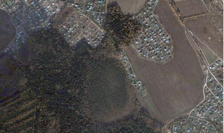
Thanks to the program Google Earth", today we can see these very characteristic structures on all continents and, accordingly, we can say that hydrogen degassing is currently widespread globally.
Fig.1. Lipetsk region. Satellite images clearly show ring-shaped subsidence structures formed at the outlets of hydrogen jets. The sizes of these structures vary from a few hundred meters to several kilometers. Their formation is accompanied by the bleaching of chernozems and the death of forest shelterbelts. The latter (the death of the stripes) clearly indicates the very recent formation of these structures.
The length of the scale bar is 800 meters (bottom left).
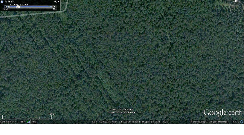
Rice. 2. Photo from July 19, 2002, 55 km east of the center of Moscow. Just a good forest. The length of the scale bar is 124 meters.
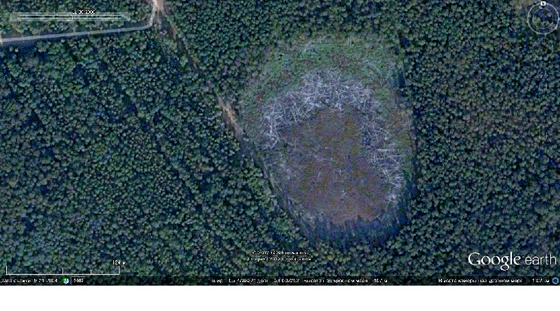
Rice. 3. The same place on September 21, 2004. A karst hole appeared, which is filled with swamp slurry (brown), gray “felt” around the ring - these are the trunks of fallen trees. The dark edging below is the shadows of standing trees. The area of the sinkhole could accommodate 6 football fields.
For information about the origin of karst in connection with hydrogen degassing, see the website
http://hydrogen-future.com/ .
Rice. 4. Moscow region, 22 km NNW from the Moscow Ring Road, between the villages of Zhilino and Verevskoye. In the center of the picture is a ring structure (dimensions 450x350 m). Old spruce forest destroyed, the structure sank, became swampy and overgrown with pine trees, the height of which does not exceed 5-6 meters. However, counting the growth rings on saw cuts showed that their age is about 85-90 years. These dwarf pines (as well as normal ones: lingonberries, blueberries, cranberries and junipers) grew on a “peat blanket” that floats, and clearly ripples in waves if you jump on it vigorously. The echo from the bottom arrives after 0.2 seconds (they deliberately hit a log with a sledgehammer and caught the echo with a seismometer). Accordingly, under the “peat blanket” in the center of the depression, the water thickness is 150 meters. Of course, this is a failure and it was formed a little over a hundred years ago. However, even now intensive hydrogen degassing is observed in this place. In 100 years, the failure shown in Fig. 1 will look the same. 3.
The Internet and the media are literally inundated with reports of sudden failures and sinkholes, which have begun to appear with alarming frequency on all continents recently.
Here is one of them (http://finalnews.ru/provali-zemli/blog.html dated February 28, 2012):
In the central Chinese province of Hunan, 693 large sinkholes have appeared this year, and their number is constantly growing. According to the Department of Land Resources of the city of Iyana, from January to February 24 of this year (i.e., in 2 incomplete months), 693 sinkholes were discovered, of which 537 were in farmland, 150 in river beds and mountain streams, 6 in reservoirs. 167 houses were damaged and more than 1,200 people were injured.
According to the stories of one of the residents of Yuejiaqiao village, such phenomena as sinkholes have been happening for many years, but this year everything is much more serious. There are more and more failures every day, and their size is also increasing. People are afraid that houses could collapse at any time, as more than 200 houses have already cracked due to subsidence. Some families were forced to move to the mountains.
So, hydrogen is currently being degassed from the deep zones of the planet. In this case, hydrogen is collected in jets, therefore, somewhere its concentration is higher, and in other places it is significantly lower. This determines variations in the plasticity of the metalsphere: accordingly, in some places it flows, while nearby (along the boundaries of the jets and beyond) intermetallic compounds and alloys can react to these flows as a brittle medium (see paragraph above 5 ) by forming cracks and sliding along them. And all this should have a “pulse-wave character”: accumulation of stress - flow - slip, accumulation of stress - flow - slip, etc.
In fact, the nature of the deformation of the medium (brittle or plastic) also depends on the speed of application of the load. For readers who are not familiar with the problems under discussion, let us explain this with a figurative example: asphalt bitumen at room temperature can be crushed with sharp blows, but if the same bitumen is pressed down with a weight and left overnight, then by morning it will spread into a puddle. A priori, we can assume that during movements in the bowels of the planet, the speed of application of the load is different and, in the language of geophysicists, “ all deformation processes are characterized by multi-frequency irregular periodicity, and disturbances must have a wave nature».
Judging by the deep-focus seismicity, tectonogens are currently at work; accordingly, large masses of the metalosphere are moving deeper into the planet, which causes a decrease in the “moment of inertia” of the Earth. Proof of this is the acceleration of the Earth’s rotation observed after every major deep earthquake (explanations about “ the work of tectonogens" see in the book " Our Earth"). And this also forces the metalsphere to flow from place to place.
In addition, the asthenosphere, in our understanding, is the upper layer of the metalsphere in which hydrogen accumulates (point 6 ). Hydrogen degassing occurs in cycles, between which there are breaks. During these breaks, the influx of hydrogen from below stops, but it continues to seep into the lithosphere, and over time the asthenosphere seems to “dry out”, loses its plasticity and ceases to perform the function of isostatic leveling. However, relief erosion and sediment deposition on the surface continue. This creates pressure gradients at the base of the lithosphere. With the beginning of a new degassing cycle, the asthenosphere is restored, its viscosity sharply decreases (see paragraph 5 above) and it begins to flow from the area of high pressure to the area of low pressure, carrying out isostatic equalization.
Our experiments have shown that at pressures above 10 kbar, the compressibility of metals should increase when hydrogen is dissolved in them (increase in comparison with metals without hydrogen). Accordingly, within the hydrogen jets, compaction of the substance (volume reduction) should occur, and the asthenosphere will flow to compensate for this violation. On the other hand, a jet of hydrogen may disappear if a more powerful flow has attracted it or intercepted its feeding zone at depth. In this case, the compaction at the site of the former jet will disappear, the volume will increase, and the substance will again move.
So, the substance of the metalsphere moves. But it is represented by conducting intermetallic compounds and alloys, which also contain hydrogen plasma in places (see paragraph 4 ). And all this is permeated with magnetic power lines. That is, conductors move in the Earth's magnetic field. Due to induction, these conductors are induced electric currents, which in turn generate their own magnetic fields. And since movement, as geophysicists say, “ characterized by multi-frequency irregular periodicity", the strength of inductive currents will vary greatly, and the intensity of electromagnetic radiation will vary accordingly. Thus, there should be local variations in the strength of the Earth's magnetic field due to movements of matter in the magnetosphere.
The frequency range of our hearing ranges from 20 to 20,000 Hertz. Geophysicists have discovered such low-frequency variations in the strength of the Earth's magnetic field that occur periodically. Some are inclined to see the cause of this phenomenon in the deformations of the internal zones of the planet, and believe that their appearance precedes major seismic events, which in a number of cases has been confirmed in practice. Others (who are the majority) believe that these variations are associated with the excitation of the ionosphere of our planet from solar flares. In all likelihood, the opinion of this majority is based on the traditional version of the structure of the internal zones of the planet, in which the entire mantle is composed of dry silicates. Silicates have no conductivity - they are insulators, and an insulator, no matter how much you shake it in a magnetic field, will not emit any electromagnetic waves.
However " Our Earth» is structured completely differently (see paragraph 1 ), and if a conducting metalsphere is forced to move in a magnetic field, then it will certainly emit electromagnetic waves. Thus, the point of view of those geophysicists who see an endogenous (intra-terrestrial) cause in this phenomenon has a right to exist. At the same time, the impact of solar flares on the Earth’s magnetosphere cannot be denied. Apparently, geophysicists will still have to figure out which electromagnetic waves come from the interior of the planet, and which are produced by disturbances in the earth’s ionosphere.
Now let's remember about the ferrous mineral - magnetite (Fe 3 O 4 ). It has a very high magnetic susceptibility, i.e. it easily becomes magnetic in a magnetic field. Its crystals are attracted to a magnet just like iron filings, and it itself can be a magnet. Inclusions of magnetite crystals in an amount of 2-5% are found in almost all rocks, and in some places it forms monomineral accumulations, accompanied by powerful magnetic anomalies. When abraded magnetic properties magnetite are not lost at all. Among light sands and sandstones, dark layers are not so rare - and most often these are sands enriched with magnetite sand grains.
In the old days when modern materials and glues were not yet known, shoes were not molded, as they are now, but were made of leather, and the soles with heels were padded with shoe iron nails, they were produced in different sizes and sold in kerosene shops. In the Urals, people believed that you should not walk in places where magnetic iron ores come out in boots lined with iron nails, because you will lose the soles and you will be “barefoot.” In such areas they tried to make shoes using copper nails. Now I don’t really believe in this popular observation. However, I had to hold pieces in my hands magnetic iron ore(from Mount Blagodat in the Urals), which had north and south poles, marked by “hedgehogs” made of dusty particles of the same iron ore. These samples attracted (and held suspended) steel knives and forks. On the Internet you can find a message that in the Nizhny Tagil Museum of Local Lore there is a heavy steel weight hanging on a block of magnetic iron ore, and it has supposedly been hanging for several decades. In short, magnetite is truly a highly magnetic mineral.
Low-frequency variations in the magnetic field will necessarily affect magnetite crystalline grains. And the strength of this impact will depend on the intensity electromagnetic radiation, which is associated with fluctuations in magnetic field strength. The intensity of electromagnetic radiation depends on the distance to the source of electromagnetic disturbance waves. The question of possible locations of these sources can be resolved by direct observations. We will return to this below.
In addition, solids have the ability to fall into a state of resonance from vibrational physical influence of even very low power, it is only necessary that the periodicity of this influence coincide with the resonant (natural) frequency solid. And then this body, if it is small, will sing in a treble on the note of its frequency, and if it is large, then it will hum in the bass in the gut. Here it should be taken into account that during resonance, standing waves are generated in the body, which are transverse waves. And for a body to “sing” at a certain frequency, it must be within its size to fit at least one half-wave of this frequency.
It should be especially noted that there are a lot of these crystals. If the average diameter of magnetite grains in rocks is 1 mm, then for each cubic meter of rock there will be 55 million of these grains (at 5% - the weight of the magnetite content). And they are distributed fairly evenly throughout the volume of the rock. Tens of millions of crystals, evenly distributed in each cubic meter and capable of synchronously vibrating from electromagnetic waves, is an absolutely ideal design for organizing the phenomenon of resonance in rock blocks.
Our ear perceives frequencies from 20 to 20,000 Hertz. Let us determine the size of a monolithic block whose natural frequency is 300 Hertz. Shear wave velocities in crystalline rocks vary around 3000 m/s. At this speed, the wavelength with a frequency of 300 Hertz is equal to 10 meters, respectively, the half-wave length will be 5 m. Consequently, a monolithic five-meter (along the long axis) block will sing at a frequency of 300 Hertz. By the way, in tone this is closest to the note " re"first octave.
Few people know that stone blocks can “sing”. We found out about this by accident. Once in Kazakhstan, near our field camp, we came across a body of gabbro, which on the surface looked like a collapse of monolithic blocks of elliptical shape. The upper blocks lay completely free, and some of them touched the collapse with only three points. These “free” blocks, when hit with a geological hammer, began to hum melodiously and for a long time, each on its own note. So, on blocks with dimensions of 3-6 meters, it was possible to select all the notes of the first octave. For fun, we even picked up an immortal musical phrase by ear - “ chi-zhikpy-zhik, where have you been”, and then they performed it for the guests with sledgehammers. The success was deafening.
However, will limonolite blocks “sing” due to variations in the magnetic field? We don't know if anyone has tried to check this. Maybe the military is aware of this, but communication with them is fraught with problems. Apparently everything depends on the intensity of electromagnetic radiation. Until now, most geophysicists believe that magnetic field disturbances are related exclusively with emissions to the Sun, which “injure” the ionosphere and from here magnetic storms occur on Earth. This phenomenon has been well studied and it would be foolish to doubt the obvious. The scale of this phenomenon raises doubts; they are such that magnetic storms (which come from the Sun) capture, if not the entire planet, then at least one hemisphere, entirely and at once.
At the same time, the Earth's Rum is observed in different places at different times and very locally. This is in no way consistent with super-global scales magnetic storms. In the same time " Our Earth", in which the conductive mantle begins with the asthenosphere, suggests the presence point sources electromagnetic disturbances at shallow depths in the upper mantle. These point(on a planetary scale) sources may be located at a depth of 100 km from the upper crustal horizons, and in some places even less, since diapirs of the conductive mantle can penetrate into the crust. In zones of modern rifting individual languages and the ridges are installed at a depth of 3-5 km. And this is not an unfounded statement, but the result of our many years of research, confirmed by magnetotelluric sounding. By the way, over these zones there are peculiar “ geological wonders“, which are absolutely impossible to explain within the framework of traditional ideas about the structure of the planet, and even more so it was impossible to predict them. However, within the framework of our concept, predicting these “miracles” turned out to be an everyday task (we will write about this separately).
So, if the planet is structured in our way, then with its modern seismicity it is obliged to create point sources of electromagnetic radiation. The waves diverging from such sources will be spherical. The intensity of a spherical wave decreases in inverse proportion to the square of the distance from the source. This can be recorded with appropriate magnetometers placed along the profile in a suitable place, for example, where the Earthly Rumble has become especially annoying. And if point source will be in close proximity to the magnetometer (at a distance of several tens of kilometers), then it is natural to expect that the intensity of electromagnetic waves will be orders of magnitude higher compared to the intensity of waves coming from distances of thousands of kilometers.
Until now, geophysicists, trying to find out the cause of the Earth's Rumble, use seismometers. As a result, they find slightly increased microseismic noise in the humming zones, and they cannot understand how very weak microseisms cause noise effects comparable to the sound intensity from powerful loudspeakers.
Dear geophysicists, shouldn’t we try magnetometers in this matter? What if anomalously intense electromagnetic radiation is discovered, coinciding in place and time with the Earth's Rumble? And if such a connection is discovered, then why not try to find a monolithic block buzzing from a sledgehammer (with a touch of magnetite) and irradiate it electromagnetic waves appropriate frequency and intensity. What if she starts singing, and then maybe even collapses?
Joke(instead of conclusion)
From the point of view of thermodynamics, you and I, dear readers, are open systems. And, to be honest, we all periodically emit gases - we dump entropy. This is one of the most important conditions sustainable existence open systems. « Our Earth“The system is also open and also emits gases. Therefore, you should not be afraid of the “Earthly Rumble” and panic. This is something to be rather happy about. After all, if our old planet is still capable of “ to fart" at times, therefore, it is still alive and capable of maintaining the living conditions familiar to us.