Bocharova Lidia Ivanovna
Geography teacher
the highest qualification category
MCOU Atamanovo school
Explanatory note
The main feature of this lesson is that it uses a presentation made at Prezi. Such a presentation has several advantages. It is carried out, and then immediately demonstrated all in a single space. The presentation can be used on-lain, or you can download and install it on your computer.
This presentation allows you to quickly switch from one slide to another, easily go back. You can switch slides by clicking, using the ←, → arrows, or by dragging the working field with the mouse. Putting the desired object in the center, you can move it away or zoom it with the scroll wheel. By double-clicking the slide itself opens in full screen mode. Due to the large volume, I do not post the presentation itself. I give the link:
https://cloud.mail.ru/public/ESp4/7hc7b76P8
Description of the use of the presentation “The geographical location of South America”
Slide - screensaver;
Slide - video "South America";
5 Slide - South America Record Nominations;
6-12 slide - checking the distribution of record nominations;
Slide 13 - Description of the mainland
14 slide - Practical work
15 slide - Checking the extent of the mainland and the coordinates of the extreme points of the mainland. I do not insist on measurement accuracy. She was convinced herself that there were discrepancies on different maps.
16th slide - return to the 14th slide, to test work: draw a conclusion
17 slide - answers to test questions (go through the slide or by dragging the working field with the mouse).
test match. It is also possible to use tests for multilevel verification.
Geography lesson on the topic: Geographical location of South America
CMD to the textbook “GEOGRAPHY. MATERIALS. OCEANS. PEOPLES AND COUNTRIES. Grade 7 "edited by V.P. Dronova
purpose: form an idea of \u200b\u200bthe geographical position of mainland South America
Lesson type: discovery of new knowledge.
Forms of work of students: frontal, individual, group.
Methods partially search.
Technologies:dialogical
ROUTINGLESSON DESIGN
| Lesson topic | Geographical location of South America |
||||||||||||||||||||||||||||||||||||||||||||||||||||||||||||||||||||||||||||||||||||||||||||||||
| Planned educational outcomes | |||||||||||||||||||||||||||||||||||||||||||||||||||||||||||||||||||||||||||||||||||||||||||||||||
| Subject | Meta subject | Personal |
|||||||||||||||||||||||||||||||||||||||||||||||||||||||||||||||||||||||||||||||||||||||||||||||
| Determine the geographical location of the mainland: Formulate preliminary conclusions about its nature; Compare the geographical location of South America and Africa, establish similarities and differences | Use various sources of geographic information to search for and retrieve information needed to solve educational and practice-oriented tasks; Determine the goal, problem in the educational activity. Plan activities in a learning situation. Assess the degree and methods of achieving the goal in a learning situation. To develop the ability to evaluate the correctness of the implementation of the educational task, its own capabilities for solving it; To analyze, draw conclusions. Own semantic reading. Find information in different sources to solve a learning problem. To be able to compare, think logically, classify according to given parameters. To develop the ability to establish causal relationships, build logical reasoning and draw conclusions. Learn to organize educational cooperation and joint activities with the teacher and peers; work individually and in a group. To learn the ability to consciously use speech means in accordance with the task of communication to express your feelings, thoughts and needs. Express your opinion (in a monologue, dialogue), arguing for it, confirming it with facts. | To learn the ability to consciously use speech means in accordance with the task of communication to express your feelings, thoughts and needs. Reasonedly evaluate their own and others' actions. Learn to form your own opinion and position, show interest in new educational material. |
|||||||||||||||||||||||||||||||||||||||||||||||||||||||||||||||||||||||||||||||||||||||||||||||
| Solved learning problems | How geographical location affects the nature of the mainland |
||||||||||||||||||||||||||||||||||||||||||||||||||||||||||||||||||||||||||||||||||||||||||||||||
| Lessons Learned | Dependence of natural components on geographical location. Cape Gallinas; Cape Froward; Cape Parignas; Cape Cabo Branco. |
||||||||||||||||||||||||||||||||||||||||||||||||||||||||||||||||||||||||||||||||||||||||||||||||
| Type of ICT tools used in the lesson | Computer, multimedia |
||||||||||||||||||||||||||||||||||||||||||||||||||||||||||||||||||||||||||||||||||||||||||||||||
| Educational Internet Resources | Presentation https://cloud.mail.ru/public/ESp4/7hc7b76P8 |
||||||||||||||||||||||||||||||||||||||||||||||||||||||||||||||||||||||||||||||||||||||||||||||||
| LESSON ORGANIZATIONAL STRUCTURE
|
|||||||||||||||||||||||||||||||||||||||||||||||||||||||||||||||||||||||||||||||||||||||||||||||||
Appendix 1
Expedition Diary
Explorers of south america
Captain_______________________________________
Team________________________________________________________________________________________________________________________________________________________________________________________________
South American record holders: Angel, Selva, Amazonian lowlands, Andes, Amazon, Titicaca, Aconcagua, anaconda, condor.
| Definition | Record holder |
| The longest sushi mountains | |
| Highest peak of the western hemisphere | |
| Highest waterfall | |
| The highest mountain lake in the world | |
| The world's largest plain and largest equatorial forests | |
| The richest river | |
| Biggest snake | |
| The largest bird | |
Task 2 Determine the extreme points of the mainland and their coordinates:
1 team Extreme North Point ________________________________
Extreme southern point __________________________________
2 team Extreme western point ________________________________
Extreme eastern point __________________________________
The distance between them in degrees ______________________
in kilometers ______________________
Task 3 Determine in which climatic zones South America is located
.__________________________________________________________________
.__________________________________________________________________
.__________________________________________________________________
Task 4 Compare GPs from Africa and South America
| South America |
||
| How is the mainland located relative to the equator? | The equator crosses the mainland in the middle | |
| How is the mainland located relative to the prime meridian? | Zero Meridian crosses Africa in the western part. Most of the mainland lies in the eastern part. | |
| How is the mainland located relative to the tropics? | Intersects the north and south tropics | |
| What oceans is washed? | In the west - the Atlantic, in the east - the Pacific Ocean. | |
| In which climatic zones is the mainland located? | From equatorial to subtropical to the north and south. | |
| Since the equator crosses Africa in the middle, this is the hottest continent. The same extent to the north and south of the equator provides almost similar climatic conditions in the northern and southern parts. The large extent along the Northern tropic enhances the aridity in its northern part. |
Appendix 2 (Notes in a Bottle)
In ancient times, during a shipwreck, sailors put notes in bottles to communicate their whereabouts or transmit important information. Often, water gets caught in a cork and damages the text. Here I have two such bottles. Remove the notes and restore the text.
South America stretches far from the equator to ... .. Therefore, its ......... end lies in the climatic zone and has climatic seasons. The extreme northern point is called the cape ………… ..
………… ..tropic crosses South America in its narrower part. Therefore .............. there should be less zones in South America than in Africa. The length of South America from north to south .......... than from west to east. Since the equator crosses South America in its northern part, from the northern climatic zones there is only …………. The extreme southern continental point is called the cape ............
Appendix 3
Determine which description refers to South America ...
a) The mainland is located in the Northern and Southern Hemisphere. The equator crosses it approximately in the middle. The zero meridian crosses the mainland in the western part.
b) The mainland is located in the northern and southern hemispheres. The equator crosses it in the northern part. The mainland lies completely in the western hemisphere.
Choose the correct answer: Cape Pariñas is indicated on the map by the number ...
a) 1; b) 2; in 3; d) 4;
Find the superfluous:
a) the Red Sea b) the Caribbean, c) the Pacific Ocean d) the Atlantic Ocean,
Which statements apply only to South America and not to Africa:
a) The mainland has the greatest length from north to south;
b) The extreme northern and southern points of the continent are equidistant from the equator;
c) The mainland has the largest set of climatic zones;
d) There is an equatorial, tropical, subtropical climatic zone on this continent;
e) This continent is washed by the waters of the Atlantic Ocean;
f) The length of the mainland from north to south and from west to east is approximately equal.
How many mistakes were made in the text:
Most of South America is located in the Southern Hemisphere. The Strait of Magellan is located farther south than the Strait of Drake. In South America, all types of climate are represented, from the equatorial to the subantarctic. The Isthmus of Panama links South America with North America. The first Russian explorer of the nature of South America was N.I. Vavilov.
a) 4; b) 3; at 2; d) no errors.
(simpler and less time consuming)
Which strait separates South America from Antarctica?
A) Magellan B) Drake C) Gibraltar
Which strait separates South America from about. Tierra del Fuego?
A) Panamanian B) Peruvian C) Magellans
Which sea is in the north of South America?
A) Caribbean B) Black C) Mediterranean
4. South America is washed by oceans:
A) Quiet B) Indian C) Atlantic
The length of South America from west to east compared with the length from north to south
A) more B) the same C) less
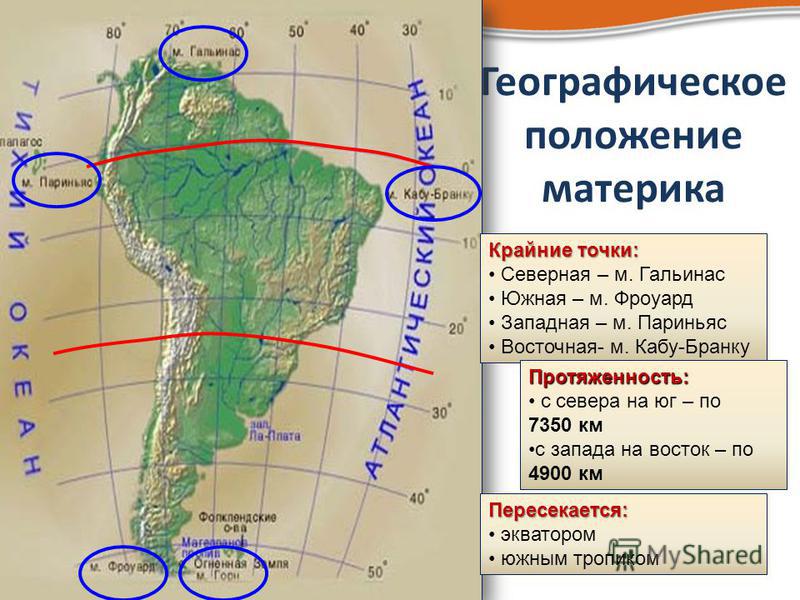
Square South America (Fig. 1) is 18.1 million km 2, and with islands - 18.3 million km 2. The largest length from north to south - 7640 km, and from west to east - 4990 km. By geographical location, South America is one of the group of southern continents. South America for the most part lies in the southern hemisphere, and only the far north of the mainland is in the northern. With respect to the prime meridian, the continent of South America is entirely in the western hemisphere. Washed the mainland in the east by the Atlantic Ocean, in the west by the Pacific, in the north by the Caribbean Sea. In the south is the Drake Strait, which connects two oceans. Extreme points continents are: in the west - Cape Parinhas, in the east - Cape Cabo Branco, in the north - Cape Gallinas, in the south - Cape Froerd.
Fig. 2. Physical map of South America ()
Fig. 3. Map of South America ()
The coastline of the mainland is almost indented. In the few bays there are large cities. Only the southern part of the Pacific coast is quite dissected. Here along the coast stretches the archipelago of the Chilean islands. By carefully looking at the physical map of the mainland (Fig. 2), you can see that the mainland is narrowing to the south. In the south, South America adjoins the archipelago of the islands of Tierra del Fuego. This name was given to the largest island Fernan Magellan(Fig. 4), passing on ships along the long and narrow Magellan Strait.

Fig. 4. Fernan Magellan ()
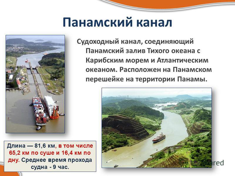
The southern limb of Tierra del Fuego - Cape Horn - the southernmost part of America's point of light. Panama Canal(Fig. 5) connects the Panama Gulf of the Pacific Ocean with the Caribbean Sea and the Atlantic Ocean.

Fig. 5. Panama Canal ()
Its length is 81.6 km. The construction of the Panama Canal lasted more than 10 years and became one of the largest and most complex construction projects of mankind (Fig. 6).

Fig. 6. Construction of the Panama Canal ()
This is a grandiose building. Through the entire Panama Canal, a ship is conducted on average in 9 hours.
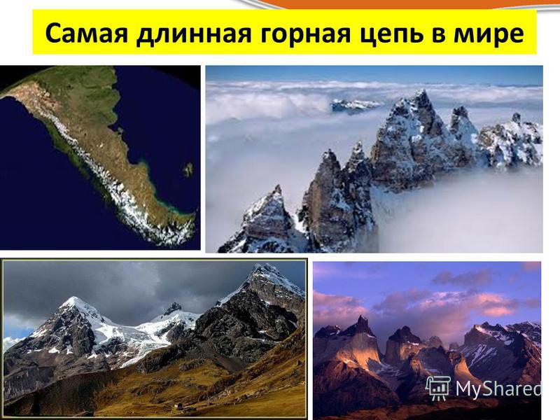
Continent South America is part of the lithospheric plate of the same name. From the west, another lithospheric plate is approaching it - the Pacific plate, which, with its thinner edge, seems to be diving under the South American lithospheric plate. A compression area is created here, and, as a result, the western edge of the continent is formed into huge mountain folds. The main feature of the relief of South America: along the Pacific coast stretches for 9 thousand km the longest mountain system of land - Andes(fig. 7).

Fig. 7. Andes Mountains ()
The eastern part of the mainland is mostly flat. Here are lowlands, plateaus, highlands. In western South America, an oceanic plate slides beneath the plate with the continental crust, where deep-sea trenches form: Peruvian and Chilean, and the continental crust crumbles into folds - the Andes rise. South America is the mainland with the most contrasting relief for the southern hemisphere. Altitude difference - more than 7 km. The relief reflects the structural features of the earth's crust. The eastern part of the mainland is located on an ancient South American platform. The Guiana and Brazilian plateaus formed on its shields, they are very rich in various ore minerals: iron, manganese, nickel, gold, aluminum, titanium, zirconium. Lowlands: Amazonian, Orinokskaya and Lapland - are located on plates where the crystalline basement is covered by a thick sedimentary cover. Oil, natural gas, coal were found in the hollows and troughs of the platform. In the south of South America and in Patagonia there is a section of a young platform. In relief, it is expressed by a stepped plateau. In western South America, a long mountain system stretches along the Pacific Ocean — the Andes, which for almost the entire length consist of a system of parallel ridges and intermontane basins. The bowels of the Andes are very rich in minerals, especially ores of non-ferrous and rare metals. The intermountain and foothill troughs are rich in oil.
Andes began to form when South America was still part of Gondwana. Mountain building, caused by the convergence of lithospheric plates, continues to this day, therefore, earthquakes and eruptions of volcanoes such as San Pedro, Cotopaxi, Ljulyayljako. This indicates that the Andes are young mountains and their growth continues. A catastrophic earthquake occurred in the Andes in 1960 in Chile. Tremors of tremendous power lasted 7 days. During this time, 35 cities were destroyed, hundreds of settlements wiped off the face of the earth, at least 10 thousand people died. More than 2 thousand people were left homeless. The tsunami washed away and destroyed port facilities and fishing villages.
The Andes Mountains have passed a long geological path of development, and, in accordance with the difference in development and structure, the following zones can be distinguished in the Andes: eastern and western. The Eastern Andes are the ranges that arose in the Cenozoic era due to the blocky uplifts of the Paleozoic folded structures that formed earlier. The steep slopes of the eastern Andes arose due to the breaks of the earth's crust. The Western Andes are high and medium in height folded-block mountains that arose in the middle or at the end of alpine mountain formation. The greatest peak of the Andes is the mountain Aconcaguawhose height is 6960 m (Fig. 8). Most of the rivers, originating in the Andes, flow into the Atlantic Ocean.
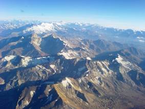
Fig. 8. Mount Aconcagua ()
Only comparatively small streams originating in the western part of the Andes flow into the Pacific Ocean. In the Andes is the largest lake - Titicacalocated on the Indian plateau at an altitude of 3812 m (Fig. 9). Its maximum depth is 304 m. Fresh water.
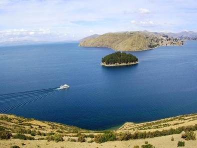
Fig. 9. Lake Titicaca ()
On the inner plateaus of the Andes there are many lakes of tectonic origin - shallow, drainless and saline. The mountainous relief of the Andes determines the development of altitudinal zonation here.
The plant world formed as the mountain system itself grew. The great length of the Andes from north to south is the reason that different sections differ in the composition and number of altitude zones. Ranges with great height are located in equatorial latitudes and include different zones. Equatorial forests, differing little from the Amazon forests, are located up to a height of 1 thousand m.

Fig. 10. Andes mountain system ()
Up to a height of 3 thousand m - mountain and alpine forests, in which there are bamboo, hindu tree, ancient ferns. Up to 4 thousand meters low trees, shrubs, light forests begin to appear in the forests. Here heather, myrtle, undersized bamboos are found. Over 4 thousand m - alpine meadows. The vegetation consists of sparsely growing turfy grasses, pillow-shaped. Mossy swamps are located on flat areas, and steep slopes are characterized by barren rocky spaces. And over 4 thousand 500 m - a belt of eternal snow and ice.
Each continent has a special characteristic, which significantly distinguishes it from others. You can talk about South America as the mainland of natural phenomena.
Looking at the world map, you can see that America consists of two large continents and, thus, forms a single part of the world.
Between themselves, two continents (North and South America) are connected by a long Panama Isthmus, in one part of which the Panama Canal was laid.
general characteristics
The area of \u200b\u200bSouth America is 18 million km2, the mainland is completely located in the Western Hemisphere.
The mainland of South America stretches from north to south for about 7 thousand kilometers, and from west to east - for about 5 thousand. It narrows to the southern tip.
Cape Froward is considered the southernmost point of the mainland, Cape Gallinas is the northernmost, Cape Cabo Branco is the easternmost point, and Cape Parignas western.
But the continents of America were not always interconnected - when they were divided, their development occurred independently of each other.
South America Crosses equator, and 10% of its territory is located in the northern hemisphere. Thus, most of the mainland is located in the southern hemisphere.
Since the southern tropic passes through its territory, this determines the presence of certain belts - tropical, equatorial and subequatorial. And the southern part of the mainland belongs to the temperate and subtropical zone.
You can talk about South America as wet mainland. The southern part of the mainland is narrowed, and the northern and central ones are expanded. In the southern part, the tropical zone prevails, which leads to a large amount of rainfall.
The Atlantic Ocean, which washes the eastern territory, has a significant impact on the natural conditions of the mainland. Due to the fact that there are plains in this territory, moist air masses without obstacles penetrate into South America.
A warm The Caribbean, the only one in South America, washes the north coast. Brazilian and Guiana currents also contribute to an increase in humidity on the mainland. Famous bays of South America: San Jork, La Plata, Bahia Grande and San Matias, but none of them can be called large.
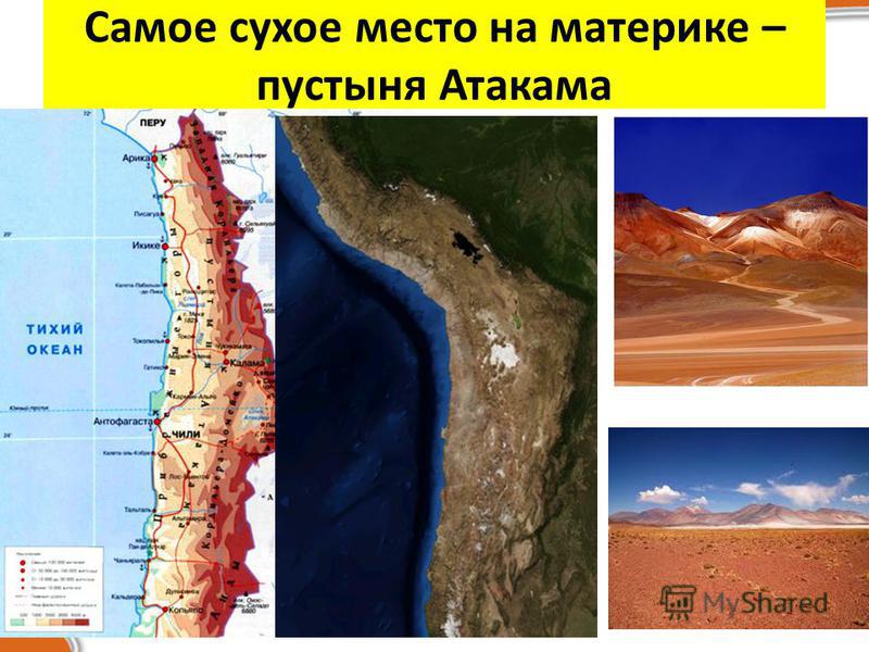
The influence of the Pacific Ocean falls on the southern and western coasts of the mainland. But it cannot be called significant, since it is limited andes mountain system. This part of the continent is characterized by cold ocean currents (for example, the Peruvian current).
And the extreme southern strip of the mainland is separated from Antarctica by the Drake Strait, and, despite this, the influence of the natural conditions of this continent on the nature of this part of South America is quite noticeable.
Topic: “The geographical position of South America. Discovery of the mainland. "
(Geography, VII class).
Lesson Objectives: To form a general idea of \u200b\u200bthe originality and nature of South America. Determine the geographical position of the mainland and the features of the coastline. Trace the history of the discovery of South America (the voyage of H. Columbus, the journey of A. Vespucci). To develop students' practical skills in working with atlas and contour maps. Promote environmental education for students.
Equipment : Globe, physical map of the world, physical map of South America.
Lesson Type: Learning new material.
During the classes.
I .Organizing time.
II . Updating reference knowledge .
Conversation on the issues.
1.What plan is the mainland characterization made up of?
2. Why the study of any territory begins with a determination of the geographical location.
III . Motivation of educational cognitive activity.
The teacher reads a poem by V. Bezladny, and students watch a slide show.
If across the ocean
Sail to the other side
You will get to the mainland
"South America".
And on that continent
There is a river deep
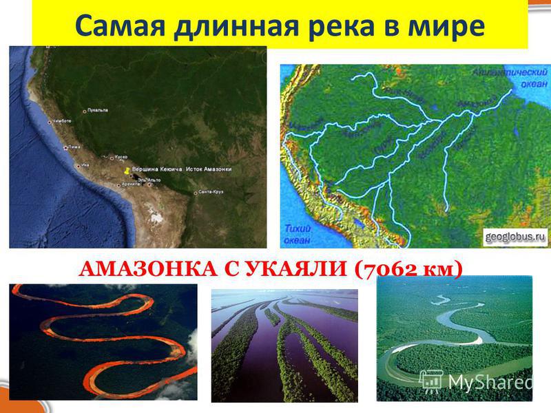
Of the world famous rivers
The widest.
There - a wall in the way -
Jungle impassable:
Do not pass an Indian
Not an idle tourist.
They rush to the watering hole
Beasts in the early morning
And in the water teeming with
Scary piranha.
There hovering over the Andes
Condor bird
A snake crawls in the jungle -
Anaconda.
If the tail hooks its
Behind a big tree
That will get his head
To the other side
And over this bridge
It will be easy
Cross the river
Or run around.
"What is your name, river? .." -
Yelling loudly
And in response, from afar -
"Amazon!.."
IV . Learning new material.
Students, using Figure 2, on page 5 of the textbook, compare the area of \u200b\u200bSouth America with the areas of other continents. Before starting to study the new material, it is necessary to recall what the geographical location of the mainland is, and invite students to determine the geographical location of South America.
The teacher encourages students to answer questions.
1. How is South America located in relation to the equator? (the equator crosses, i.e. lies in the southern and northern hemispheres, the latitude will be northern and southern).
2. How is South America located in relation to the 0 meridian? (west of the 0 meridian, i.e. in the western hemisphere, longitude will be western).
3.How is South America located in relation to the tropics? (The mainland crosses the southern tropic, i.e. most of the mainland lies in a hot belt of illumination).
4. How is South America located in relation to other continents? (close to north North America in south Antarctica).
5. How is South America located in relation to the oceans? (in the west Pacific Ocean, in the east Atlantic).
Students find on the map in the atlas the extreme points of the mainland and mark them with a contour map. Four students, called one at a time, on the chalkboard write the name of the extreme points and determine the geographical coordinates:
north - Cape Gallinas 12 ° N, 72 ° W
south - Cape Froward 54 ° S, 71 ° W
western - Cape Pariñas 5 ° S, 82 ° W
eastern - Cape Cabo Branco 7 ° S, 34 ° W
During the teacher’s story about the extreme points, viewing a slide show.
Cape Gallinas (from Spanish - “chicken”) is located on the Caribbean Sea. It was discovered in 1500 by the Spanish expedition Ojeda, in which Amerigo Vespucci took part.
Cape Froward (from English - willful, acting contrary, unfavorable) is located on the shore of the Strait of Magellan. This name was received in January 1587 from the English pirates, due to difficult conditions and adverse climate. On the cape stands a large metal cross, built in honor of the visit of Pope John PaulII in Chile in 1987.
Cape Parinhas is located on the Pacific coast, formed by a low-lying ledge of the coast, which is covered with loose sediments. Discovered in 1527 by the Spanish expedition Francisco Pizarro. There is a lighthouse on the cape. If you climb the cape, you can see below in the bay of seals.
Cape Cabo - Branco (from the Portuguese White Cape) is located on the shores of the Atlantic Ocean. The cape is formed by white sandy beaches, over which sea terraces rise. There is a lighthouse on the cliff of the cape. Discovered in 1500 by the Spanish navigator Diego Lepe and named after St. Augustine San Augustine.
Students measure the length of South America from north to south:
From the equator to Cape Gallinas 12 ° and from the equator to Cape Froward 54 °
12 ° + 54 ° \u003d 66 ° 111.3 km x66 ° \u003d 7345.8 km;
Students measure the length of South America from west to east:
From the 0 meridian to Cape Parinhas 82 ° and from the 0 meridian to Cape Cabo - Branco 34 °
82 ° - 34 ° \u003d 48 ° 110.9 km x 48 ° \u003d 5323.2 km.
After that, the coastline is examined. Students find large islands, bays and straits on the maps of the atlas; or work with the textbook on page 124.
The history of the discovery of the mainland.
Watching the video - film "Discovery of South America.
After watching the movie, the teacher concludes.
Students make notes in a notebook.
1499-1504 - expeditions of Amerigo Vespucci.
XIX century - scientific research by Alexander Humboldt and Charles
Darwin.
V . Fastening.
Performing practical work on a contour map, page 125 of the textbook.
VI . The teacher summarizes the lesson and gives grades.
VII . Homework. Read §31, questions on p. 126.
![]()


Panama Canal A navigable canal connecting the Panama Gulf of the Pacific Ocean with the Caribbean Sea and the Atlantic Ocean. Located on the Isthmus of Panama in Panama. The length is 81.6 km, including 65.2 km by land and 16.4 km by the bottom. The average passage time of the vessel is 9 hours.
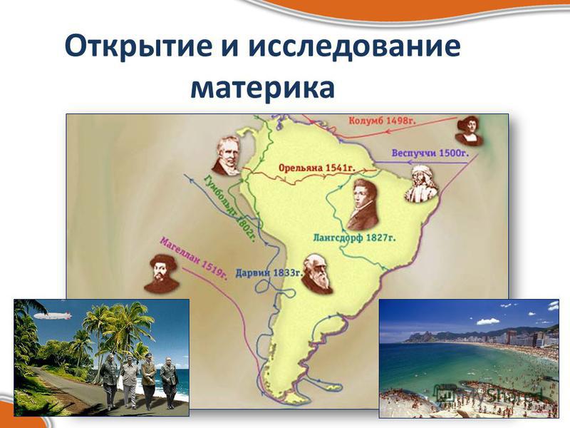
Christopher Columbus, October 12, 1492. Columbus was the first of the well-known travelers to cross the Atlantic Ocean in the subtropical and tropical strip of the northern hemisphere and the first of Europeans to go to the Caribbean. He ushered in the discovery of South America and the isthmuses of Central America. He discovered all of the Greater Antilles, the central part of the Bahamas, the Lesser Antilles, as well as a number of small islands in the Caribbean and the island of Trinidad off the coast of South America. In total, he made 4 trips to America: 1st - August 3, 1492 - March 15, 1493, 2nd - September 25, 1493 - June 11, 1496, 3rd - May 30, 1498 - November 25 1500, 4th - 9th May 1502 - November 1504

Amerigo Vespucci, 1507. Amerigo participated in the equipment of Columbus expeditions, was familiar with him. The successes of Columbus inspired him to leave the business to get acquainted with the new lands. In letters to noble friends, Vespucci described his travels and geographical discoveries. In addition to Vespucci's letters, many books and diaries of his travels were published. Advertising did the trick - it was his name that began to be associated with the newly discovered mainland, and in 1507, the cartographer Waldszemuller attributed the discovery of a new continent made by Columbus, Vespucci and called it America, and in 1538 Mercator called this name the northern part of the mainland.

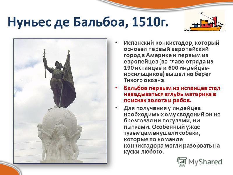
Nunez de Balboa, 1510. The Spanish conquistador, who founded the first European city in America and the first of the Europeans (led by a detachment of 190 Spaniards and 600 Indians, porters) went ashore of the Pacific Ocean. Balboa was the first of the Spaniards to go deep into the mainland in search of gold and slaves. To obtain the information he needed from the Indians, he did not disdain either promises or torture. Particularly terrifying to the natives were dogs, which, at the command of the conquistador, could tear anyone to pieces.
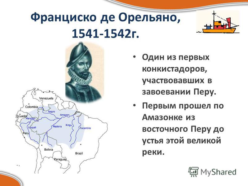
Francisco de Aureliano, g. One of the first conquistadors to participate in the conquest of Peru. The first to go through the Amazon was from eastern Peru to the mouth of this great river.
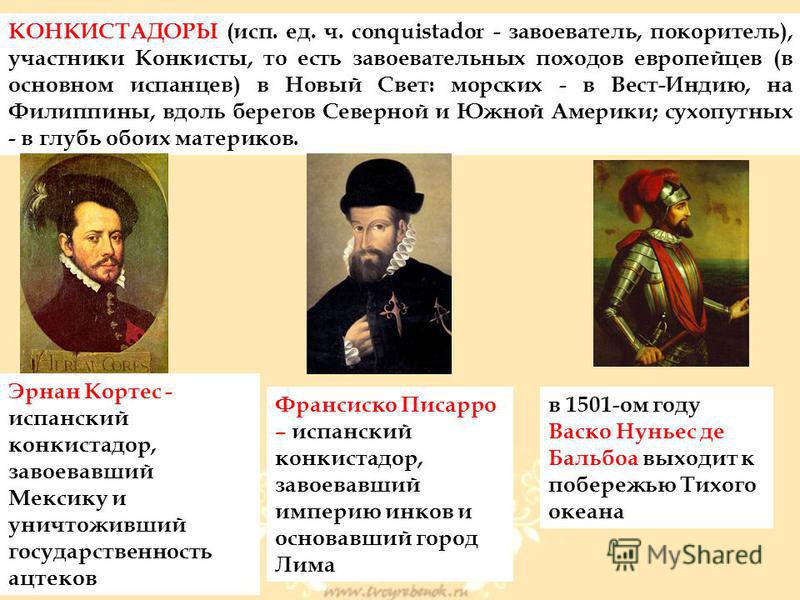
CONCISTADORS (sp. Unit conquistador - conqueror, conqueror), participants in the Conquista, that is, the conquest of Europeans (mainly Spaniards) in the New World: sea - in the West Indies, the Philippines, along the coast of North and South America; land - deep into both continents. Hernan Cortes - the Spanish conquistador who conquered Mexico and destroyed the Aztec statehood Francisco Pizarro - the Spanish conquistador who conquered the Inca empire and founded the city of Lima in 1501. Vasco Nunez de Balboa goes to the Pacific coast
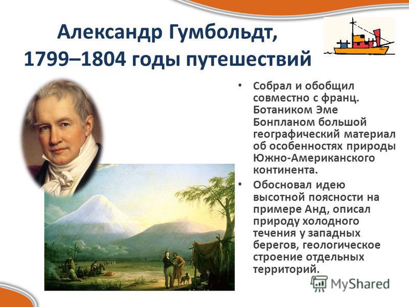
Alexander Humboldt, 1799–1804 years of travels Collected and summarized together with the French. The botanist Aime Bonplan is a great geographical material about the nature of the South American continent. He substantiated the idea of \u200b\u200baltitudinal zonation on the example of the Andes, described the nature of the cold current near the western shores, and the geological structure of individual territories.
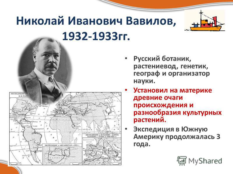
Nikolai Ivanovich Vavilov, years Russian botanist, plant grower, geneticist, geographer and organizer of science. Established on the mainland ancient foci of origin and diversity of cultivated plants. The expedition to South America lasted 3 years.
Geographical location of the mainland Extreme points: North - metro Gallinas South - metro Froard Zapadnaya - metro Pariñas Vostochnaya - metro Cabo Branco Length: from north to south - 7350 km from west to east - 4900 km Crosses: equator to the south tropic