Australian continent with an area of \u200b\u200b7,686,850 square meters. km. It is the smallest and oldest of all the continents of the planet. It is located between Antarctic ice from the south and the tropical islands of Indonesia archipelagoes from the north. It is mostly flat, flat and pretty dry continent, up to 40% of its territory is in the tropics, it takes it a desert to one third.
Relief Australia
The orographic pattern of the continent is mainly plain. In the middle part of the Australian continent there is an extensive lowland with a high height of no more than 150 m and a natural depressor, where at an absolute height of 15 meters below sea level is located drying salted lake Air. Central plains stretched between Karpenary bays and large Australian.
In the midst of it, low mountain ridges are often found, consisting of the collapsed rates of the platform basement. The world's world's property in the continent of the region was the presence of ancient rock on the planet. They did not destroy here almost since Neogene.
Here in the center of the mainland there are plain plateau and lowlands - plain Carpenaria and extensive areas of the largest plain on the continent of the Greater Artesian basin. Significant territory coverage The plain pool of the largest rivers Murrey and Darling is characterized by small height differences.
In the west, the mainland is a large plateode with a height of 400 to 500 meters, separated by erosion processes into separate low ridges and table-terrestrial mountains. The relief decreases here only to the ocean coast, there is an extensive low-lying plain nullarbor.
The eastern part of the continent is more raised, here are quite low, over time, strongly destroyed Gerced Mountains of the so-called large waterproof ridge and the Australian Alps. The mountain peak of Kosyushko with an absolute height of 2228 m The highest peak is here in the Australian Alps. The Mountains of Australia compared to the major mountainous countries of the world look rather modestly and are considered mountains with small heights.
Relief link with geology
In the geological structure of the mainland, almost all known specialists are the types of rocks of all geological periods in the development of land with a duration of 3.8 billion years. The equificious nature of the continent is due to the fact that it is located on the ancient Indo-Australian Precambrian Archean platform.
In the east, the platform is framed by the Tasmansk Gersin geosyncline reduced in a texture structure. In the west platform there are two crystalline precambrian outputs of the foundation of the Pilbar and Yingar Shield Platform Platform. In the terrain on the site of the Archean tectonic shields, consisting of ancient crystalline rocks of gneisov, granites and plateau granulites are located.
Characteristics of individual relief forms
Australian Alps
The highest ridge on the continent Australian Alps total up to 400 km long and up to 150 km wide stretched four longitudinal zones along the south-east coast of the mainland. The first of them is coastal arrays, stretching along the ocean coast.
For them there is a band of interhoems lowlands, some of them reach the height marks significantly below the sea level. The zone with the highest peaks of the Australian Alps stretched over the lowlands band. It is in this ridge that the Mount Kostyushko is located with a height of 2228 m. The fourth strip of deep into the continent stretched, so-called downs - a chain of hilly footprings.
Large waterproof ridge
Mountains with this title stretched along the entire Eastern coast of the continent for 4 thousand km. It is clearly divided into two, isolated in the orographic plan of the part: Ridge Quinsland and South Wales Mountains. Mountains were formed as a result of the non -ogenic destruction of a folded mountain country formed in Paleozoa.
A mountainous country in the north is significantly narrowed and passes in places in coastal, folded with loose accumulative deposits of the plain. Mountain country is an ancient granites, Gabbro and Gneis. The eastern slopes of the mountainous country are cool, the ocean breaks, they are strongly dissected by the ancient and modern river valleys.
North of 28th sh. The mountains of the waterproof ridge are relatively low and expand to 650 km. The ridges that are located closer to the shore are achieved in a height of 1000 meters, there are elevated plateau among them. They are separated from the Western Mountain chain with low-lying basins.
South of 28th sh. The local mountains become noticeably higher and monolith. There are separate ridges with the names of New Ingland, Liverpool, Glaid Mountains, Hestings, Mac Fersson, and South of All Australian Alps. River flows, among them, Murray and Darling begin with the slopes on the waterproop ridge. Many dams are built in the mountains to generate electricity.
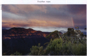
Blue Mountains
On the lands belonging to the new South Wales, there is a unique corner of the waterproop, the so-called blue mountains, is unique in origin and beauty. They are called so because of the SIZY of the blue haze, which is created over the forests of abundant eucalyptus evaporation.
The mountain system of the blue mountains stretched to the west of Sydney by 50 km. The height of the blue mountains ranges from 1200 m to 1300 m, they are strongly dissected by rock canyons to 800 m. In the geological structure is heterogeneous.
To the west of the coke dividing them into two parts, the limestone part of them is located with numerous rope shapes, the eastern part of them consists mainly of durable multicolored sandstones. On the territory of this facility, UNESCO is located 8 protected by the state natural territories, including the National Natural Park of the same name. It is designed to preserve the unique eucalyptus forests of the continent.
On mountain paths, there are groups of tourists here, travelers, guests of the country are often coming here. A mountainous country near Sydney has become a popular and easily accessible object of tourism, although access to some areas of mountains due to their environmental status is closed. But it is here that the most interesting and most beautiful natural objects of the cave, canyons, waterfalls are located.
Here, nearby is the coolest to the degree of slope in the world the Katuomb railway line. Some 415 m long road was built on a steep slope to lift the shale and coal mined in the mine. Now the road was reconstructed and used in the form of a popular tourist facility.
Rock Ulur.
In the center of the Australian continent there is an amazing natural education, in the middle of the desert there is a monolithic reddish-brown rock formation of Uluru. There is a natural geological unicum of 450 km south-west of Alice Springs. According to specialists of geologists, it has been formed more than 680 million years ago, in the midst of an ancient lake reservoir Amadius.
The sizes of the rocks are impressive, with a length of 3.6 km, it has a width of up to 3 km and the height from the foot of 348 m. In the form of her outline, they resemble a giant figure of the elephant lying on the side. At the base of the mysterious cliff there are many natural caves, on the walls of which archaeologists found ancient petroglyphs. The rock is a sacral and mystical place of worship of local aborigines to the owner of the sacred mountain, worshiped by them by Water Python, here they carry out rites and offer him.
In 1873, the mysterious Rock of Uluru discovered and comprehensively described William GOS. Rock then, as it looks impressive now. They published it seems completely smooth. But close, on its washed shoes and sheepdown with tropical sand hurricanes of the surface, you can see deep cracks and irregularities. Cliff cracking also cause differences in day and night temperatures. The night in the desert is cold, and the heat may reach + 38 ° C - + 40 ° C.
Folded the mysterious rock of an amazing reddish-pink shade with coarse-raised durable sandstone, it was formed in the destruction of red granites. Among the sandstone there are quartz, field swap and, undoubtedly, iron oxides. They gave a bright "rusty" color. A special color gives her the ability to change its color with different lighting with the sun.
At dawn, the dark rudder cliff quickly brightens and becomes a bright purple shade. In the rays rising over the sun, the sun becomes blooming, then it becomes pink, and by the middle of the day copper-gold. This game of shades of a giant stone giant inspired a reverent alert to the Aboriginal Nanang.
The interest of travelers to the rock-wide in the desert began to appear since 1950, when the road was built in its surroundings. Every year to half a million tourists arrive at the most interesting tourist site. In 18 km north of the rocky massif, a famous tourist area with a small town for tourists Julara and Airport for receiving travelers Ers-Rock. In 1987, the unique rock formation of Uluru was entered into the list of natural monuments of global importance under the auspices of UNESCO.
Since 1985, the terrain around the rock education and the Scala Uluri itself by the Government decision belongs to the local Tribes of Anang. But the leaders passed the rock in the village of the Government of the country for 99 years with the condition that the locality will be protected by the state and be used as the same name national Park. The rent amounted to 75 thousand dollars, and in favor of the tribe there are 20% of the ticket price. Local aborigines in every way encourage the development of mass tourism near Uluru.
A little more than 200 years ago, Australia was poorly populated by aborigines. In 1788, the first European settlers arrived in Australia the first fleet (First Fleet), created in 1786 by order of Lord Sydney for transportation of 750 prisoners. A total of 1,487 people on the ships, of which 1030 remained in Australia. Now the country's population is about 19 million.
The capital of Australia Canberra (Canberra) Australia is divided into 6 states, two internal areas and 7 external: Victoria (VICTORIA, VIC) Capital Melbourne (Melbourne) New South Wales (New South Wales, NSW) Capital Sydney (Sydney) South Australia , SA) Capital Adelaide (Adelaide) Queensland (Queensland, QLD) Capital Brisbane (Brisbane) Western Australia (Western Australia, WA) Capital Perth (Perth) Tasmania (Tasmania, Tas) Capital Hobart (Hobart) Territory of the Federal Capital (Australian Capital Territory , ACT) Capital of Canberra (Canberra) Northern Territories (Northern Territory, NT) Capital Darwin (Darwin) External territories: Norfolk Island Island (Cocos Islands), Christmas Island (Christmas Island) and other population indigenous Aborigines, Equatorial and Europioida race.
Anthropologists refer them to the Australian race. The aboriginal population is small, is about 1% of the inhabitants of the mainland. In ethnically, the aborigines are divided into numerous tribes, sealing in various languages. The main modern population of the Angloavaistralist, the descendants of the colonists from the UK and Ireland, as well as the emmigrants from Europe and Asia moved here. Official language Australia English. The population is about 17 million people. The average population density is 2 people per km. kV Most of the population live in large cities in the south-east of Contineta (Melbourne, Sydney, Canberra, etc.). The Australian Union is the world in the world that occupies the whole mainland. Capital of Canberra State, Cultural and Administrative Center of Australia. The 1996 census showed that 17,892,423 people lived at the Australia, which is 6.2% more than in 1991.
The population of Australia is old; The average age is 34 years, and 12.1% of the total population aged 65 years and older. From among the entire population, 73.9% were born in Australia, and among all the other 36.2% of profit from England. There are immigrants from New Zealand and Ireland, but most (after England) from Italy, Vietnam, Greece, China and Germany. The number of aborigines by origin increased by a third from 265 458 in 1991 to 352,970 in 1996. Among them, 55.8% were taken into account in the states of New South Wales and Queensland. Among the population of the northern territory, aborigines are 23.7%. Everywhere, except for the northern territory, the number of women (50.5%) is more than men (49.5%). English language (state). Due to the large number of immigrants, you can hear all the options and accents of English, as well as Chinese, Italian, Russian, Greek ... plus a variety of dialects of the indigenous people of Australia Aborigines. The climate of the seasons are opposed to European: the hottest time in December and January, the Australian winter in June and August is the highest, low, large in Australia ... The highest mountain Mountain Kostyszyko 2,229 meters. The highest point of Peak Mooson Island Heard 2 754 m. Australia is the lowest continent in the world, the average height is only 330 meters.
The lowest point of Lake Ire (Lake Eyre), 15 meters below sea level. The southernmost point of the mainland South Point Cape Wilson (Wilson`s Promontory) south of Melbourne. South East Point in Tasmania is the southernmost point of the continent with the exception of Antarctica. The longest river Murray (Murray River) and EE inflow p. Darling River. Together they reach 3,370 km., And their pool is more than a million square kilometers, that is, 14% of the entire territory of Australia. The largest state of Western Australia, with a territory of more than 2.5 million square meters. km. Australia itself is the biggest island, then Tasmpnia is followed, and Melville Island island, located near Darwin and occupies 5,786 square meters. km the smallest staff is Tasmania. The highest temperature, +53 s, is incorporated in Queensland in 1889.
Geology of Australia
Australia is the smallest mainland size. Its area is 7631.5 thousand km2, which is about 2/3 of the area of \u200b\u200bEurope. The northernmost point of the mainland Cape York is 10 ° 41 "Yu. Sh., The South-Southeast South-Eastern 39 ° 11" Yu. sh. The mainland extends from west to east at 4100 km (from Cape Schip-Point at 113 ° 05 "century. D. To Cape Byron 153 ° 34" c.), From north to south, the largest length of sushi is only 3200 km. Coastline Dissected weakly. Large bays are only two carpenteries and a large Australian. Bass, the Strait separates from the mainland the island of Tasmania.
Australia, Tasmania Island and other small islands in the quiet and Indian Oceans constitute the territory of the Australian Union. The east coast of Australia accompanies a large barrier reef stretching almost 2000 km from Cape York to Tropic. Its width in the north is about 2 km, to the south, it increases to 150 km. From the shore he is separated by a lagoon, a depth of 50 m, also expanding to the south. The big barrier reef is cut into narrow passages, allowing the ocean vapor to penetrate the open ocean in the quiet coastal waters. The relief of Australia is simple and resembles the relief of Africa. Western half of the mainland is engaged in a western plateau, a wide strip of central lowland is adjacent to it stretching from Karpenary Bay to the Indian Ocean. On the eastern outskirts of the mainland a narrow strip of mountains, called the East Australian Mountains. The nature of Australia has many features that distinguish it from other parts of the globe. Australia, first of all the mainland of relics. Real species of plants and animals are distinguished by high endemism, deep antiquity and are preserved on the Australian land due to its long-term isolation. In the mainland, the extensive ancient alignment surfaces are left unrelated erosion, armored by the latitite barks and conditioning the plain nature of the relief. The traces of the previous waterproofing of the now desert and semi-desert regions were not disappeared. On the other hand, there are no young folded mountains in Australia, there are no existing volcanoes and modern glaciation. All this is due to the geological history of the mainland and with the fluctuations in the climate in the geological past and gives the nature of the continent of the deep peculiarity. Geographical position I. modern features Climate causes widespread in Australia tropical desert landscapes. The northern outskirts of the mainland are occupied by savannahs and gentlemen, south subtropical type landscapes: forests on wet southwestern and southeast outskirts and savannah landscapes, steppes and semi-deserts in more arid internal areas.
Mountains stretching along the eastern outskirts of the mainland, delay wet winds with Pacific Ocean and limit the spread of wet-forest landscapes narrow coastal lowland strip and implanted slopes.
Minerals of Australia
The geological structure of Australia is most simple compared to other continents. It highlighted the Precambrian platform and the Hercinsky folded belt. The Precambrian Platform Flows 2/3 of the Statter Square Western Plateau and almost all the central lowland. The western part of the platform represents the antechalation of an ancient foundation, where the Precambrian crystalline rocks are exposed and to a lesser extent, proteozoic and younger sediment suits. Eastern part of the encryption platform of an ancient foundation. The Precambrian base here is lowered and covered with the thickness of mesozoic (mainly chalk), paleogenic and non-warmetic and lake sediments. Gercinsky folded structures are foggy of the Eastern Mountain Welcome. In addition to Paleozoic folds, sediment, volcanic and intrusive breeds of all ages are involved in its structure. The Australian platform has been failed and the vibrational movements that occurred in connection with the tectonic movements in geosyncline framing it from the West and from the East. The West Australian Geosyncline, laid in the Precambrian, was part of a huge geosynclinal zone, which framed the Archean and Proterozoic Sushi nuclei in the southern hemisphere. The Nizhneopeozoic folding and oscillatory movements, which occurred in this zone, created land links between the Precambrian platforms of Australia, Southeast Asia and Africa, who retained in the Paleozoic Era and in the first half of the Mesozoic. The splits that led to the separation of Australia from Africa and Southeast Asia occurred only in the chalk period.
In the East Australian, or Tasmansk geosyncline, the Nizhneopeozoic folding formed a mountainous country, which in the West adjacent to the aligned Australian platform, and in the east went beyond the limits of the modern outlines of the mainland. but main role In the formation of the mountains, a VerkhnePaleozoic folding had, as a result of which, from under the sea level, a huge portion of the mountainous sushi Tasmanthis was raised, stretching at the site of Tasmanov and coral seas. From the end of Paleozoic, Tasmanthis's sushi experienced slow oscillations; At the beginning of the mesozoic, the deflection captured the central lowland. They led to the ingression of the seas and to the formation of extensive lake pools, in which limestone and clay-sandy strata were deceived. Seas and lakes for a long time isolated Western aligned Sushi of Australia from East Highland. The general raising of the mainland at the end of the chalk caused the retreating of the seas and the crossed, and the drying of the lakes. The northern and eastern outskirts of the Precambrian structures of Australia and the Gersinian structures of Tasmanthis were framed by the Alpine Geosyncline.
Tectonic movements in it led at the end of the chalk to loss of land connections with Southeast Asia and preserved from the immersion by New Zealand structures. Powerful folding formation in the Alpine geosynclinal occurred in neogen. High Mountains of New Guinea, New Zealand and Highlands of Islands between them were erected. On rigid caps of Australia and Tasmanthis, the folding reflected in faults, the movements of the block on them, the introduction of intrusions, volcanic activity, slow deficits and raising. Raised the western dump edge of the mainland; On the Earth, Tasman was separated by the reflats of the Kimberley's grieving. From the southwestern outskirts of the Western Plateau, the Trenns Lake Range Randers-Lofti ridges were separated. The most significant changes in the relief, as well as in the sizes and outlines of the mainland occurred in the East. The lines of faults dropped to the bottom of the Pacific, the considerable part of Tasmanthis, its western outlet, preserved from dive, highly raised, which caused the orographic severity of the East Australian mountains. Basalt covers that occupy particularly large areas in the central and southern ridges were prevented on their ancient breeds. In the quaternary period, the boundary parts of the mainland continued to slowly fluctuate. There was a final compartment from the mainland of Tasmania and New Guinea; The lowering of the individual mountainous sections of the coast created finely raised rice shores on the island of Tasmania, in the north-west and in the east of the mainland. The nature of the relief of Australia is determined by the ancient of the categories of its structures and long-term adhesion. The latter led to the alignment of huge territories, so that in the relief, first of all, amazing his amazing monotony: the mainland is a plateau with an average height of 350 m, i.e. It is after Europe the lowest part of the sushi. From the previous higher levels, the plastlery island mountains are preserved (in places of sedimentation sediments) and islandish massifs (in places of crystalline rocks). The largest area occupies the surface of the alignment, created for the period from the end of the chalk to the neogen, the so-called Great Australian Penpetlen. It has a height of 300-500 m on a western plateau, does not rise above 200 m in the central lowland and raise up to 700-1500 m in the East Australian mountains, where he can be traced in the same levels of flat-axle arrays. The widespread and good preservation of alignment surfaces and, in particular, Australian Penethelen is explained by the slowness of the vertical Sushi movements and the weak degree of relief dismembrance in the conditions of predominantly deserted climate, as well as the booking effect of protective core.
Irony and siliceous protective barks are mainly maintained from neogen when they had the necessary climatic prerequisites for their occurrence and seasonally humid conditions. The formation of limestone, gypsum and sulphate protective crops began at the end of the neogen in a dry and hot climate and continues in the inner areas of Australia. Short-term wetting and cooling in the plungy epochs of the Quaternary period led to the formation of erosion form of relief (river valleys, lake Kotlovin, etc.), preserved in modern desert areas. Glacial sculptural forms, as well as ice accumulation relief, are characteristic only for the Australian Alps of the only region, where, in addition to the island of Tasmania, there was a quaternary glaciation. Features of the Tectonic structure of Australia make it possible to allocate three structural-morphological provinces on the mainland: Western plateau, central lowland and East Australian mountains. The Western Plateau coincides in general in its outlines with the Antekliza of the Precambrian foundation, represents the weakly dismantled surface of the Great Australian Penetheln with an average height of 300-500 m. At its eastern outskirts, the crystal ridges of McDonnell and Masgrave ridges will be raised on its eastern outskirts. Western plateau). The western edge has extensive flat-terrestrial residual arrays (Hammersli Range, etc.). The south-western edge of the plateau, steeply cutting towards a narrow coastal lowland along the reset line, is called the Darling Ridge. In the north-west plateau framed by a kimberly mountainous massive, in the north it ends on the Arnhedral Peninsula.
Huge areas in the inner areas occupy sandy and stony deserts. The sandy deserts are a large sandy and large Victoria desert lie on the northern and southern slopes of Western Plato and are separated by the rocky desert of Gibson. In the south-west, lake basins witnesses of the wet epoch of the Quaternary period were preserved. In the south, karst plain nullarbor is allocated. Central lowland. The prerequisite for its formation was the deflection of the eastern outskirts of the ancient Australian platform, the immersion of the part of the Caledonian folded structure, as well as subsequent sea and lake regimes. The thickness of marine and lake sediments hid the irregularities of an ancient relief, which acts only in the form of weakly pronounced hills on the lowland outlook. Its average part, the so-called central pool, lies in the area of \u200b\u200bLake Air 12 m below the ocean level. This is the lowest place of Australia, in the western half of the pool there are deserts, continuing the Western Plateau desert belt.
The southeastern part of the central lowland is occupied by the accumulative plains intersectable by the largest rivers of Australia Murrey and Darling. In the lower torque, Murrey, west of the river, highlights the area of \u200b\u200bthe mountain-lobby ridges of Flinders-Lofty. East Australian Mountains. For a long time they were called Australian Cordillera, however, by the type of relief, they differ sharply from Cordiller both northern and South America. This ancient (mostly Hercinsky age) Horst-block mountains, already strongly destroyed, with medium heights of about 1000 m, for the most part Flat-pass. The discharges and faults of Paleogen and Neogen crushed them into separate ridges and arrays. Reset along the Eastern Coast of Australia led to a steepness of the Eastern slopes; More spoil Western slopes descend to the central lowland with hilly foothills (downsami). The outpouring of basalts, accompanied by split, in many places imposed their mark on the form of the ridges. Step plates are confined to linear outpounds, volcanic cones to central type eruptions. In the highest mountain range, in the Australian Alps (Peak Kosyushko 2234 m), traces of Quaternary glaciation are preserved: Caras, triggers, glacial lakes. In limestones, the compounds of the tops of the blue mountains and some others are developed as a karst. Minerals. Due to the weak development of sedimentary covers for Australia, a significant predominance of ore fossils over non-metallic is characterized. The areas of the most active metallity are focused along the western outskirts of the mainland and in the southeast, in the contact areas of platforms from the platforms, and in the East-Australian mountains, in the folded Caledonian and Hercinian structures in the East Australian Mountains. Australia has significant gold reserves, non-ferrous metals and iron ores. The leading role among the ore fossils is played by gold, the main deposits and the areas of production of which are focused on the south-west of Western Australia (Calgohryli, Kultgarti, etc.), in Victoria (Bendigo, Ballarat) and in Northeast Queensland (Charters-Taers to South -Repad from Townsville, etc.). The most significant area for the extraction and reserves of southwest, covering extensive in the broad band between the Merchison River and Dandas. Ore non-ferrous metals are concentrated mainly in the east of Australia. The largest deposit (and the main area of \u200b\u200bproduction) of copper ore is located on the island of Tasmania (Mount Layell); Large deposits of copper ores are available and developed in Queensland (Mount Morgan, Mount Isa). Very great in Australia, the reserves of polymetallic ores of zinc and lead, as well as silver.
In the first place in the reserves and mining of polymetallic ores there is a new South Wales. Broken Hill deposit is one of the world's largest. A significant amount of silver and zinc is mined in the north-east of Australia in Queensland (Mount Isa), as well as on the island of Tasmania. It is also necessary to mention the very large reserves of tantalum and niobium, industrial deposits of which are concentrated in Western Australia (Pilbarra). The uranium ore deposits are explored and operated in South Australia (Mount Painter and Radium Hill) and in the Northern Territory (Ram-Dzhangl, etc.). The main area of \u200b\u200biron ore deposits near Iron Nob in South Australia, although the larger than in Iron-Nob, stocks are available on the islands of Koulen and Coat in the UMPI's bay (north of the mouth of the Fitzroy River), as well as in the Merchison River basin. Production in these areas is currently almost not conducted in view of the difficulty of delivering ore to the metallurgical plants of the new South Wales. According to the reserves of stone coal, Australia is in the first place among the countries of the South Hemisphere. The largest coal pool (Permian age) is located in the new South Wales and occupies a very favorable geographical position, stretching out a strip of 250 km along the Tasmanian coast. The most powerful layers of high-quality coals are focused in the area of \u200b\u200bNewcastle cities (mainly) and Sydney. The second pool value is located in Queensland (in the areas of Brisbane and Claremont). The corners of this permocarbon age basin. Brown coals (tertiary age) are mined in an open way in Victoria, in the vicinity of Melbourne; There are exploration about the opening of new reserves of brown coal from Adelaide. Intelligence on oil, strengthened currently, has not yet given practical results. The main reason for the lack of oil on the mainland is the small number of pools with a sufficient power of marine sedimentary rocks in which oil could accumulate.
Climate Australia
Australia lies in the latitudes from the subequatorial in the north to subtropical in the south and only the island of Tasmania almost entirely lies in a temperate belt. In accordance with such geographical position One of the main factors affecting the climate of the continent is a high total solar radiation that reaches in the north-west of 140 k / kal per CM2 per year. Compared to South Africa and South America, south of Equator Australia is more stretched from the West to the East. With a weak dismemberment of the coastline, this determines the constantly high temperatures of the internal areas and gives the right to consider it the fierce part of the sushi of the Southern Hemisphere. The climate is most of the mainland continental.
Sea air penetrating sometimes far into the deep areas from the north and south (which favors the absence of orographic obstacles), quickly warms up and loses moisture. East Australian Mountains detain wet winds from the Pacific Ocean, leaving from the western periphery of the South Pacific maximum, and separate the ocean sectors from continental. The climate of these narrow coastal sectors is influenced by the warm East Australian current. The Darling Ridge also limits the narrow oceanic sector of the Mediterranean climate in the south-west. The coastal strip in front of it is somewhat cooled by a weakly pronounced cold West Australian flow. The coast of the north of the Darling Range is under the influence of winds that flow from the eastern periphery of the South Indian maximum, and summer monsoons. The latter, along with winter cyclones, bring a small amount of precipitation with you, so the deserts on the western outskirts of Australia are replaced by semi-derangements. From December to February, the continent is strongly heated, especially its northern and northwestern parts; This is a hot season of the year. In the north of Western plateau and almost in the entire northern half of the central lowland, the average air temperature is above 30 ° C. At the extreme south, an isotherm 20 ° C passes due to the strong heating of sushi over it is installed low atmospheric pressure-Australian minimum. The areas of high pressure above the Indian and quiet oceans at this time of the year are shifted to the south and, connecting, capture the southern outskirts of the mainland. From the north-west to the inner region of low pressure, wet equatorial air is delayed, highlighting abundant precipitation only on the coast. On the peninsoles, Arnhenth and York drops over 1000 mm of precipitation per year. In the inner areas, these rains, although they determine the summertime precipitation of the north line Cape North-West city Sydney, but in general there are little effective south of 19-20 °. sh. Precipitation drops no more than 300 mm and dominate semi-desert and desert.
From the south to the low pressure region, southeast and southern winds are delayed. But they come from higher latitudes (from high pressure) and precipitation do not give. Therefore, in the summer in the south of Australia, it is very dry: in Perth (in the south-west) of 850 mm annual Ospalkov For summer accounts for only 32 mm, i.e. about 4% of the total amount. Passing over the hot land, the winds from the ocean quickly warm up, in the southern deserts of the Western plateau and in the south of the central lowland, it is hot weather (the average temperature of the hottest month in Kulgardi 25.3 ° C). In the coastal strip, naturally, somewhat cooler: in Perth, the average temperatures of the hottest month of 23.3 ° C. Special weather mode is installed at this time of the year on the east coast of the mainland. Winds from the Pacific Ocean (carriers of the north of 19 ° Yu. Sh. Equatorial air, south of tropical, but that both are labeled and warm), pumped up on the mountain barrier, allocate abundant orographic rains. In McKay, for example, from 1910 mm of annual precipitation for December February drops 820 mm (43%), in Sydney out of 1230 mm per annum 250 mm (20%). The weather stands hot and wet average summer temperature in Sydney 22 ° C, in Brisbane 25 ° C, in McKay 28 ° C. In the cool season of the year (June-August), the mainland is markedly cooled. On the northern coast, the average monthly temperatures are reduced by 5-6 ° C; In the other parts of the mainland by 10-12 ° C. Isothermary 15 ° C passes this season several north of the southern tropic, and isotherm 10 ° C in the Bassol of the Strait separating Tasmania from Australia. A high pressure of the Australian maximum is established on the mainland, the North Coast is influenced by the dry and hot southeastern winds of the Northern Periphery of the Australian Maximum and almost does not receive precipitation. No rains also in the inner parts of the mainland. Along the southern coast and above Tasmania, the western transfer of sea air of moderate latitudes is dominated over this season. In the strip of the polar front, which is formed between moderate and tropical air, occurs unstable weather with cyclonic rains, so the south of 32 ° J. There is a winter maximum precipitation. In Perth for June-August, 470 mm (55%) of precipitation of 850 mm per annum is only the southeastern outskirts of the mainland, where in the winter on the Eastern Perucery of the Australian maximum relatively cold south-west winds. In this regard, even in Sydney in winter, precipitation falls somewhat less than in summer. From 32 ° sh. Southern winds along the east coast are blowing down the southern winds along the east coast, and the north of the south-east tropics.
They reduce the temperature in Brisbane to 14 ° C and in McCae to 16 ° C and bring relatively little moisture: in McCai from June to August, only 130 mm of precipitation falls. Depending on the annual stroke Moisturizing, thermal characteristics and distribution of the Baric systems and air masses in Australia, the following climatic belts and regions are distinguished: the belt of the Northern Australian subcorvatory climate (up to 20 ° H) with constantly high and smooth temperatures (about 25 ° C) and alturally summer and dry winter seasons; The belt of a tropical (trade in) climate (between 20 ° and 30 ° S.) with two regions. The first region of the continental desert and semi-desert climate is stretched from the East Australian Mountains to the Indian Ocean; The second area of \u200b\u200bthe sea trade in climate occupies a narrow strip of the Pacific coast and is characterized by a hot and very wet summer and a warm and less wet subtropical climate hugs the southern part of Australia and the northern coast of Tasmania. In this belt, several areas are also distinguished: for the southwest, the Mediterranean-type climate with hot and dry summer and cool wet winter; For the south-east, the subtropical monsonic climate with the summer maximum of precipitation; There is a region of a continental subtropical climate with a winter maximum precipitation and rare summer convective rains. In the form of special subsequent, the mountain climate of the Australian Alps should be highlighted with the most fully developed high-altitude lower. Moderate climate belt includes only a tasmania for which a strong oceanic effect is characterized by a large amount of precipitation by dominant in the year western winds, and moderate temperatures.
Vegetation, soil and animal world of Australia
Australia, separated from the chalk period from southern continents And Southeast Asia, has an extremely peculiar composition of flora and fauna. The flora of it is very poor with species (total there are up to 1200 species of higher plants) and high endemic (up to 75% of plant species are endemic). In view of this, Australia, together with Tasmania, stands out to an independent Australian floral area. As part of the Australian flora, representatives of the Antarctic Flora, common with those who live in South America and New Zealand (southern beks of Nothofagus SPP, some coniferous) and with Cape Flora South Africa (representatives of the Sea and others) are preserved. This is due to the existence of household land connections held, in particular, between Australia, South America and Africa through Antarctic Mainland. In Neogen, the Australian land connected twice with the Malay Archipelago and New Guinea, had periodic ties with New Zealand, the Bismarck archipelago, Solomon and other Oceania, as a result of which representatives of the Males Flora were migrated to the mainland (from small archipelagments of Oceania) and more Young (with New Guinea). The Flora of the Malseia includes types of ficuses, pandanus, some palm trees, lianas, so-called candle tree (Aleurites Moluccana); Its distribution is limited mainly by the Northern and Eastern areas of Australia. The endemic Flora of the continent developed from the middle of the chalk period in two foci of south-west and southeast for her most characteristic eucalyptus (Eucalyptus, more than 600 species and subspecies), philloid acacia (acacia, 280 species), as well as banksia (Banksia SPP.) Nickname Kazuarina (Casuarina SPP.) And Herbal Trees (Xanth-Orrhoea Preisii). Both focus of the formation were separated by sea and lake basins up to a quaternary period, and at present there are an ecological barrier of intramicious deserts. Xerophytic flore desert arose from human and mesophytes mainly to Northern and Eastern Australia, migrating into the inner areas into the plvian epochs of the Quaternary period. The vegetation cover of the mainland reflects both the paleogeographic features of its formation and modern hydrothermal conditions. The largest area of \u200b\u200bextensive internal desert areas is occupied by the formation of cellars. On the predominance of the turny cereals of Spinifex (SPINIFEX SPP.) And the triodias (TRIODIA SPP.) The eastern intramatic desert is called spinifex, and the Western TDodyium in the north of Australia Zlakovnikov replaces first a mug-scrub of thickets of barbed acacia (acacia aneura), and then savannahs with umbrella acacias, Single sucquulent trees of Baobab Gregory (Adansonia Gregorii) and eucalyptus.
On the northern coast, receiving not only regular, but also enough abundant summer sediments, the savannah alternate with eucalyptus gentlemen, and in the valleys of the rivers, dense gallery forests are stretched, very rich in the species composition. In the south of the mainland, the grassland desert is replaced by a wide band of a mug-scrub, and where the eucalyptus dumosa eucalyptus (Eucalyptus Dumosa) is more stable (Eucalyptus Dumosa), etc. in the south-west of Australia, receiving regular winter sediments, Malli scrub gradually goes into dry eucalyptus forests covering Windward slopes of the Darling Ridge. Covered Pacific Slopes of East Australian Mountains Covered with thick forests, dry Western slopes with gentlemen with navigas Altitudes over 1000 m appear araucaria and high-seat bamboo. Between 19 ° and 30 °, tropical forests are common, as part of which the eucalyptus prevail, and the number of species of the Malezian flora decreases sharply. South of 30 ° sh. The slopes of the mountains dress monsoon subtropical forests in their lower belt dominate high-seat eucalyptus, above in the undergrowth of eucalyptus appear tree diffusers, the upper border of the forest (in the Australian Alps) and Eucalyptus snow gum (Eucalyptus Coriacea) appear. The parel of the Western slopes of the East Australian mountains consist of eucalyptus, without undergrowth, with thick ground cover from cereals and dicotyledonous and callritis cypress (Callitris Cupressiformis). Since the beginning of colonization in Australia, huge arrays of forests died and died. It greatly worsened the natural water availability of many vital areas.
Many pasture land, which remained only low-value cereals in feed. The destruction of vegetation contributes to erosion and the wave of soil cover. In Australia, all types of soils peculiar to the subequatorial, tropical and subtropical belts are released in Australia. Internal desert areas are widely developed primitive stony and clay soils. Large areas cover sands, mainly fixed. From the north, primitive soils are surrounded by a semiring of tropical semi-desert reddish-brown soils, clay and loamy. In the West, they are common to the very coast of the Indian Ocean, in the north and east they go into the red-brown soils of desertified savannas.
The latter are replaced by the red soils of highly erased savannas with their mountain differences on the Kimberly Plateau and the Arnhedral Peninsula. Along the northern coast of the mainland in places of high standing waters, there are swamp soils and stains of apodoline lathes, in the mouth of rivers flooded with tide, the soil of mangroves. In the south, in the subtropical framework of the inner deserts of the mainland, from the coast of the Indian Ocean until the middle course of Murrey and Darling are developed mainly serous and gray-brown soils of subtropical semi-deserts and steppes. As the climate moisture is increasing, they go to zonal for the Mediterranean conditions brown soils, but in the south-west near the coast of the Indian Ocean, brown soils are inferior to relict red and yellow-beams, preserved from a more wet and warm climate of Neogen, which are widespread latheric bark. On the plains of Murrey Darling, where winter maximum precipitation is also expressed, a strip of brown soils, moving closer to the foothills in the red soils of subtropical savannas. In the East Australian Mountains north of 28 ° sh. Mining brown soils are developed, they are inferior to the place of apodoline reds and yellow-beams and mining brown soils, replacing (on the tops of the Australian Alps) mountain-meadow. An even greater endemism and relicity compared to Flooma are manifested in the fauna of Australia and the new Guinea and Tasmania adjacent to it, which constitute the Australian zoogeographic area in it to this day, representatives of the fauna of the Mesozoic and Tertiary Time (for example, most of the living on Earth are preserved) and, On the contrary, there are almost no highest mammals. It is assumed that the sample and other low organized animals penetrated Australia in the chalk period before separating it from Eurasia for land connections through the Malay Archipelago. These links stopped by the appearance of highly organized animals, in particular, predatory. The absence of predatory contributed to the unhindered evolution of the silent, which has achieved the highest development in neogen and at the beginning of the Quaternary period. It was at this time that the arrivals of the coughless chapels and the family of Kangaroo, Vombatov, Kusks, etc.) appeared at the highest level of development compared to their ancestors in multi-itezing compared to their ancestors. The development of the chasciers went through the line of convergence with higher mammals, i.e., according to the development of similarities similar to them. Therefore, the above-mentioned common vitality with higher mammals living in the same environmental conditions.
The most numerous family of kangaroo-analogue of manproken, the Vombat family is close to rodents, a family of couscous to flying proteins, etc., Kangaroo, womb, sideways different species live throughout Australia. The predatory silent wolf and the devil live only on the island of Tasmania, there is also a sumpaught Bear Koala. In Australia, single-passing egg-plating mammals are preserved (in deserted and semi-desert regions) and installations (southeast). Echidna Ground Animal, feeds on ants and termites, waterproof leads water lifestyle and occurs in river planes. Endemic bats and rodents are inhabited from higher mammals in Australia, as well as a wild dog Dingo, who fell on the mainland during his population of man. From the birds for Australia are characterized by endemic ostrises of EMU (inhabit mainly in Western Australia), Casual (for North Australia), the subfamily of the parrot kakada, lyroid, a paradise bird, weed chickens (laying eggs in a heap of plant residues) and black swans (south -Waspad Australia). In Australia, many poisonous snakes, lizards (including a sideline lizard). Two kinds of crocodiles live in the Queensland Rivers. From fish, it is necessary to name an ancient two Ceratode fish, the area of \u200b\u200bwhich is also limited by the Rivers of Queensland. Very rich fauna arthropods (many mosquitoes, flies, scorpions and poisonous spiders). During colonization in Australia, a large and finely horned cattle, rabbits (incredibly broken), foxes, many European birds were delivered and well acclimatized.
Vegetable world of Australia
Since the Australian mainland is long, starting from the middle of the Cretaceous period, was in the conditions of isolation from other parts of the globe, its plant world is very interesting and peculiar. Of the 12 thousand species of higher plants, more than 9 thousand endemics, i.e. they grow only on the Australian continent. Among the endemics, many types of eucalyptus and acacia, most typical of Australia plants. At the same time, there are also plants that are inherent in South America (for example, South Beech). South Africa (representatives of the protein family) and the islands of the Malay Archipelago (Ficus, Pandanus, etc.). This suggests that many millions of years ago there were land units between the continents. Since the climate of most of the territory of Australia is distinguished by a sharp dryness, dubbed plants dominate in her flora: special cereals, eucalyptus, umbrella acacia, succulent trees (bottle and dr.). Trees belonging to these communities have a powerful root systemwhich is 10-20, and sometimes 30 m goes to the ground, so that they, like a pump, suck moisture from large depths. Narrow and dry leaves of these trees are painted mostly in a dull gray-greenish color. In some of them, the leaves are addressed to the sun by an edge, which helps to reduce the evaporation of water from their surface. In the extreme north and north-west of the country, where hot and warm northwestern monsions bring moisture, rain rainforests grow. In their wood composition, giant eucalyptus, ficuses, palm trees, pandanas with narrow long leaves and others are prevailed, and others. Thick foliage of trees forms almost solid cover, shadowing the Earth. Bamboo bamboo meets places on the coast itself. In those places where the shores are flat and etc, mangall vegetation develops. Rainforests in the form of narrow galleries are stretched at relatively small distances inside the mainland on the valleys of the pek. The farther to the south, the land becomes climate and the hot breath of the desert is felt. Forest cover gradually radically. Eucalyptus and umbrella acacia are located in groups. This is a zone of wet savannah, stretching in the latitudinal direction south of the rainforest zone. In its own way, savanna with rare trees resemble parks. Shrub's teenager in them is not. Sunlight freely penetrates through the lattoon of small leaves of trees and falls on the ground, covered with high thick grass. For central deserted parts of the mainland, where it is very hot and dry, characteristic thick, almost impassable thickets of prickly low shrubs consisting mainly of eucalyptus and acacia.
In Australia, these thickets are called scrub. Skrab places are interspersed with extensive, deprived of vegetation with sandy, stony or clay deserts, and in places with thickets of high turned cereals (Spinifex). The eastern and southeastern slopes of a large waterproof ridge, where many precipitation falls, covered with dense tropical and subtropical evergreen forests. Most of all in these forests, as well as everywhere in Australia, Eucalyptus. Eucalyptus are valuable in industrial. These trees do not have equal height among rocks with solid wood; Some of their species reach 150 m of heights and 10 m in diameter. The growth of wood in eucalyptus forests is large, and therefore they are very productive. Many in forests are also tree horsages and ferns reaching 10-20 m heights. At its top, tree ferns carry the crown of large (up to 2 m length) of the centered leaves. With his bright and fresh greens, they somewhat revive the faded bluish-green landscape of eucalyptus forests. Above in the mountains, the admixture of pine damarra and beech are noticeable. Shrub and herbal cover in these forests are diverse and dense. In less wet variants of these forests, the second tier form herbal trees. On the island of Tasmania, except eucalyptus, many evergreen beecles, related to South American species. Ha southwestern forest mainland covers the Western slopes of the Darling Ridge, facing the sea. These forests are almost completely consisting of eucalyptus reaching considerable heights. The number of endemic species here is especially great. In addition to eucalyptus, bottle trees are widespread. They have an original bottle-like trunk, the thickness of the base and sharply narrowing up. On the rainy season in the trunk of trees, large moisture reserves are accumulated, which are spent in a dry period. In the teen these forests there are a lot of shrubs and herbs, milking bright colors. In general, the forest resources of Australia are small. The total area of \u200b\u200bforests, including special areas, consisting mainly of species having soft wood (mainly pines radiant), at the end of the 70s ranged only 5.6% of the country's territory. The first colonists did not find vegetable species characteristic of Europe on the mainland. Further, European and other types of trees, shrubs and herbs were delivered to Australia. The grape vine was well invented here, cotton. From grain wheat, barley, oats, rice, corn and others. As well as vegetables, many fruit trees, etc. In Australia, in the natural sequence, all types of soils are presented in the natural sequence, characteristic of tropical, subequatorial and subtropical natural belts.
Inland Water Australia
The position of most of the mainland in the belt of a deserted and semi-deplete tropical climate causes the weak development of surface runoff of both external and internal. According to the total annual flow (350 / km2), Australia stands in the last place among other continents. Almost all of its area layer is about 50 mm per year. The largest values \u200b\u200b(400 mm or more) layer of drain reaches on the wind-widen melted slopes of the East Australian mountains. 60% of the mainland area is devoid of flow to the ocean and have only a rare network of temporary watercourses (screams). The most thick network of screams in the central pool, much less of them on Western plateau. Water appears in them only after episodic rainfall, they often end in the drawing basins who were in the plungyous epochs of a quaternary period with large freshwater lakes that fed the waters of large constant rivers. Now these lakes are almost dried, their baths are busy with salt marshes. Even the largest drawless lake of Australia Ayre on a dry season is covered with a coot with a capacity of up to 1 m, and in the rainy season (in summer) bottled on an area of \u200b\u200bup to 1500 km2 off the coast of the lake ends the beds and diamantine in Australia. The outskirts of Australia have stock to the Indian Ocean (33% of the flow with the total area of \u200b\u200bthe mainland) and to the quiet. The rivers flowing into the ocean are usually short, with a steep drop profile, especially those that flow from the East Australian mountains. The flow volume, as well as river levels, is different and significantly depends on the amount of precipitation and the time of their loss. The most fully and uniform on the flow of rivers, beginning in the East Australian Mountains (Berdekin, Fitzroy, Bernett, etc.). The least free and non-permanent River of the Western Coast (Fortescia, Gaskina, etc.) flowing from semi-desert coastal plateau. The surface runoff is absolutely absent on the karst plain nodalarbor, adjacent to the Great Australian Bay. In Australia there are only two major rivers-Murray and Darling. Beginning in the Australian Alps Murray is the most-water river Australia (pool area 1072 thousand km2, length 1632 m). Its mainly rain and less snow. Beating with a barely noticeable bias on the extensive southeastern plains of the central lowland, the river loses a lot of water to evaporation and barely reaches the ocean. At the mouth, sandy braids are brazed. The main influx of Murree the Darling River The longest river Australia (the area of \u200b\u200bthe pool is 590 thousand km2, the length is 2450 m), but it is even less complete, and in the seasons of the drought of its water, being lost in the sands, do not reach Murrey.
A distinctive feature of Australia is its wealth of underground waters. They accumulate in the artesian basins that are taking the deflection of an ancient foundation along the edges of the Western plateau and in the central lowland. The aquifers are mainly Mesozoic sediments, water-resistant dense Paleozoic breeds. Underground water supply occurs mainly due to atmospheric precipitation. Underground water in the central parts of the pools are located at large depths (up to 20 m, in places up to 1.5 km). When drilling well, they often go to the surface under natural pressure. The largest underground water pool of Australia is called the Large Artesian Basin. It covers almost the entire central lowland from Karpenary Bay until the average flow of the Darling River. There is a swimming pool the greatest number Artesian wells, giving mineralized water, sometimes warm and even hot. In semi-desert and desert regions of Australia, artesian pools are of great importance, but they are used in view of the mineralization of water, not so much for irrigation, as for the needs of industry and transport and, mainly, to create reservoirs in pasture areas (in the south of Queensland, in the new South Wales and Victoria ).
Geographical zones of Australia
In Australia, the same as in Africa, the geographical zonality is clearly expressed, since the prevailing plain relief does not violate its manifestations of the middle and the most wide part of the mainland in the tropical belt causes predominant development in Australia geographical zones This belt. Among them are the most common zone of tropical spinifix deserts, with stony and clay primitive soils and large sandy arrays, but, unlike Africa and South America, Australia's deserts do not go to the west coast. Due to several elevated moisturizing, the zone of shrub semi-deserts is stretched there. In the north of the semi-desert, they occupy a narrow strip and quickly replace in the subequatorial belt zones of Savannnes, steady and shrubs with red-brown and red soils in the inner areas of the savanna, they carry aridity features with a wide development of the formation of a mog-scrub) (in the subzone of deserted savannas). The north, in the lane of moderately insufficient moisture, there is a type of typical savannah, with dense cereal cover and individual trees on the coast of the Arafur and Timor seas, where, due to a very wet summer, moisturizing reaches the optimal norms, the subzone of wet high-tailed savannes and savanna forests appears. The first occupies are the best drainage places and greater soil dryness, the second are confined to the turf and downstream of the relief with a higher level of groundwater standing. In the south, the tropical desert zone is framed by the zone of subtropical semi-desert, which occupies the largest area in the inner continental sector. It is characterized by a mog-scrub and open karst landscapes of the plain nullarbor. In the south-west and southeast of the semi-desert very quickly switch to the shrub steppes on gray-brown soils with thickets of Mallie-Scrab. At the extreme south-west, the steppe zone passes to the mediterranean dry forests and shrubs and shrubs with Ausonal relictic yellow-bees and red robes in the latitic barks. In the south-east, as it approaches eastern highlands, moisturizing increases due to summer monsoon rains, as a result of which the steppes are replaced by the zone of peculiar eucalyptus savannas with dense herbal cover and eucalyptus gentlemen on river valleys. East Australian Mountains The only significant zonal-orographic barrier of Australia. Along the world's eastern slopes of the mountains are stretched, as noted, forest zones, landscape differences of which depend on the position in the subequatorial, tropical or subtropical belts.
In the subequatorial belt (north of 19 ° sh.) Lies the zone of constant-wet forests, for which high summer temperatures and significant annual amounts of precipitation, floral wealth and the presence in the coastal lane of latitite apodoline soils are characterized. Between 19 ° and 30 ° sh. The zone of trade in tropical forests is stretched on the red, and yellow-beams. Finally, the southeastern slopes of the East Australian Mountains lie in the zone of wet subtropical forests, under which mining brown tillats were formed. On Western leeward slopes, forest zones are clearly detected only in the northern part, where the mountains reach the greatest width. Typically, wet subequatorial forests go to the zone of mixed (deciduous-evergreen) forests presented in the Australian conditions by eucalyptus palpal.
Source - Geographic Encyclopedia
Australia (Australia), the smallest mainland and part of the world; Located with the surrounding islands (Tasmania, Kangaroo, Melville, Butter, Got Island, etc.) in Southern Hemisphere.
General. Area 7631.5 thousand km 2 (with islands about 7704.5 thousand km 2). Extreme Points Mainland: in the north - Cape York (10 ° 41 'South latitude), in the south - Cape South Point (39 °' of southern latitude), in the west Cape Schipa Point (113 ° 05 'East longitude), in the east - Cape Byron (153 ° 34 'East longitude). The southern tropic crosses the mainland almost in the middle. From the south, the West and the North Australia is washed by the Indian Ocean and its seas (Timor and Arafura), from the east - the seas of the Pacific Ocean (Tasmanov and Coralov). The coastline is disseminated weakly. Inland mainland, two large bays are deployed: in the south - a large Australian, in the north - carpenter, dividing the greatest Peninsula Cape York and Arnhem Land. The largest of the islands within the mainland shallow - Tasmania, separated by a basal strait. Along the northeastern coast, a large barrier reef is extended by 2,300 km - a unique coral education included in the World Heritage List.
 Relief. Australia is the lowest of the mainland; The average height is about 215 meters. The absolute height of 95% of the territory does not exceed 600 m (see the map Australia). In Western Australia, a flat relief prevails (height 400-500 m) with numerous ridges and cutlets. The Range Hammersley Ridge (height 1251 m) rises in the West (height 1251 m), in the south-west - the darling lowland ridges (height 571 m) and sterling (height 1096 m), in the east of the high-blooded ridges Mac-Donnell (height 1511 m) and Masgrave (height
1440 m), in the north - Kimberly Plateau (height 937 m). Intermore deflection of central Australia correspond to extensive reservoir and accumulative plains: nullarbor with rope formations, deserted and flat central lowland with depressions, Lake Air-North (the lowest point of Australia, 16 meters below sea level), Murrey (Marri) and Darling, Coastal Plain Bay Carpenary. In Eastern Australia, a large waterproof ridge with steep oriental and gentle hilly hilly (so-called dances) is highlighted by Western slopes, it is stretched by 4 thousand kilometers along the eastern and southeastern coast of the mainland.
Consists of a number of isolated plane and low-bearing ridges (Gregory, Clark et al.), Separated by river valleys and longitudinal intermountain brands; It is crossed by the transverse ridges of Drammond, Expened, Liverpool, and others. South of 28 ° south latitude. The large waterproof ridge is a narrow chain of medium-sided arrays and ridges (from north to south): Hunter, blue mountains, Callarin and highland Australian Alps with the highest peak of Australia - Mount Kosyushko (height 2228 m) in the Snow Mountains Array. On the tops of the snowy mountains there are forms of mining and glacial relief. The southern outskirts of the mainland are occupied by the average and lowland folder-blocks Flinders (height
1180 m) and Mount Lofty (height 932 m).
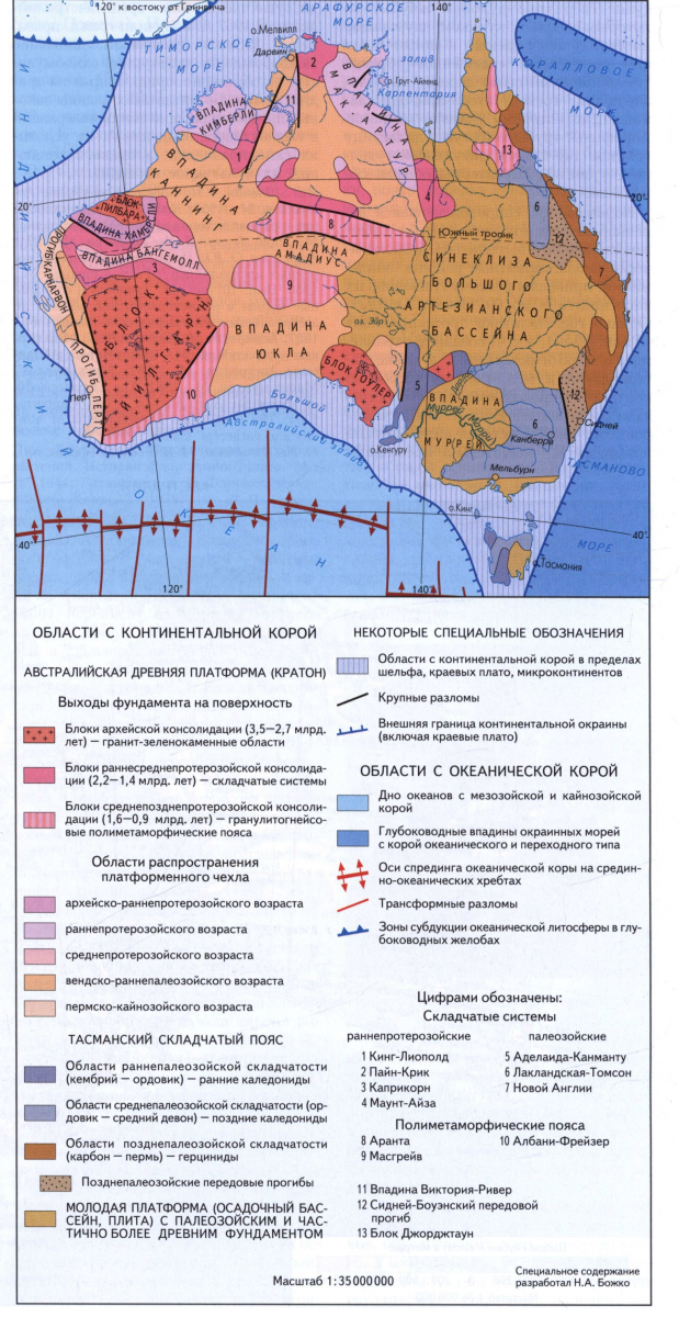
Geological structure. The territory of Australia in the tectonic plan is divided into the Precambrian Australian platform, which includes the Western and central part of the continent along with the Arafura Sea, and the Tasmansky Paleozoic Foldless Belt in the East (see a tectonic map). The structures of the Tasmanskaya belt and the Australian platform are partially blocked by the cover of the young platform (the synclesia of the Big Artesian Basin).
The Australian platform is a fragment of an ancient supercontinent of Gondwana, unpaved in the mesozoic. The outputs of the Metamorphic rocks of the Archean-Medium Proteorozoic foundation form shields (blocks) of Jiigarne, Pilbara, Aranta, Masgrave, Gowler, etc., as well as protrusions in the North-West and the North (Pine Creek). The structure of the foundation highlights the blocks of the Archean consolidation and proteozoic moving belts. Pilbar and Yiharn blocks are the Archean granite-green-molded areas folded by the rocks of the granite and greenflaw belts. In quartzits of the Jilgarian block, the most ancient zircones (4150 million years) were found. The Pilber Block's greenflaw belts (3.5-3 billion years), and the block of Jilgarne Latearhase (3-2.7 billion years) age and are complicated by basalts, comatitis, acid volcanics and chipped rocks. The exits of non-earraged Archean formations are also known to the Gowler plateau and the protest of Pine Creek. Rannertroterozoic folded systems folded by volcanogenic sedimentary rocks and granitoids have developed in the range from 2.2 to 1.6 billion years. These are Holts Creek and King Liopold systems with the age of final deformations of 1.85 billion years old, Pine-Creek, Tennant Creek - 1.9-1.7 billion years, Caprikorn - 1.75-1.6 billion years. In the folded systems of William and Mount Isais, active tectonic development continued on average proliferation to
1.4 billion years. In Central Australia, the blocks of Aranta, Masgrave, Zone Albani Freser, Paters have undergone in early and medium, protein repeated tectonic deformations, metamorphism and granitization with the formation of mobile polymethmortic belts. The last episode of magmatic activity in these belts in the interval of 1000-900 million years led to the final consolidation of the foundation of the Australian platform. The formation of a platform cover began in Late Archey (Hammersley Protosoinclee - 2.8-2.4 billion years old) and continued in Proterozoa in Vpadina Nabwebra (2.2-1.7 billion years), Mac-Arthur, Birrindudud and Kimberley (1, 8-1.4 billion years), Banganell, Victoria River and South Nicholson (1.4-1 billion years old), Amadius, Office, Ngalia, Georgina (about 900 million years). The plywoods were formed by syneclises (depressions) Joseph Bonaparte Bay, Cunning, Yukla, Grabena (deflection), Karnarvon, Avlacogen Fitzroy, and others.
Paleozoa, Mesoza and Cenozoa are represented by shallow-domestic, lagoon and continental sediments of all systems. In Kebria, the outpouring of the platiplotes in the Wpadine Kimberley took place. At the end of Carbon - the beginning of Perm developed a coating glaciation. In the late chalk as a result of the rifting, the separation of Australia from Antarctica and the Industan Block ended. In the east of Australia, there is an extended (3500 km) Tasmansky folded belt, in which folded systems - Adelaide-Kanmante, Thomson, Laclane and New England, who completed the development, respectively, in Cambrian, and the Early Ordovic, Ordovic, Middle Devon, and at the end of Paleozica, respectively . The folded Laclane and New England systems are divided by Sydney-Bowen advanced deflection. From Triass, the entire territory of Australia developed in platform mode. The czech of Jurassic-Cretaceous age forms a large (2000 km in diameter) Syncliza of the Bolshoi Artesian Basin, overlapping the folded formation of the Tasmanskaya belt, Karpenaria, Murray.
Minerals. Australia occupies leading places among the parts of the world in the reserves of uranium, diamonds, nickel, titanium in Ilmenit-rutile places. Also extremely rich leads lead, zinc, tantalum, gold, iron, manganese, bauxites, phosphorites, brown and coal, oil and natural gas, etc. (Table).
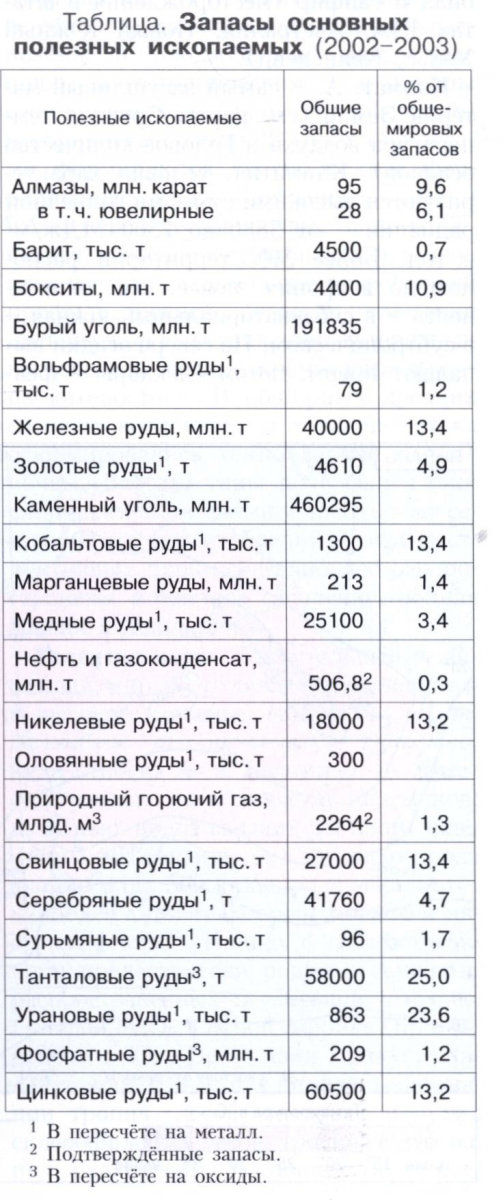 Unique in the reserves of the uranium deposit are known for the Gowler Plateau (Olympic Dame) and the protest of Pine Creek (Jabiluk, Ranger). In East Kimberly, one of the largest diamond indigenous fields in the world is a lamproit tube Argail. The deposits of sulfide nickel-cobalt ores (Cambalda) and gold ores (Calgohurli) are connected with the Archean greenland belts of Western Australia. Golden mineralization is also noted in the structures of the Proterezhoye and Plyonozoos (the states of Queensland, the new South Wales, the Northern Territory, etc.). Nickel ore deposits are known in the Masgraiv Block. Pedaginal ledge deposits, zinc, silver, copper focused in Proterozoic structures - a folded Mount Isa-Isa system, Captain Mac-Arthur, etc. (Broken Hill, Mac Arthur River, Mount Isais). Deposit of lead ores - on the island of Tasmania. With the Latearhasian-early Proteurozoic sedimentary strata, the deposits of ferrous quartzites are connected, the reserves of which in the Wpadine Hammersley (iron ore pool) are among the largest in the world. Rud Tantalian deposits - in Western Australia (Greenbushes and Wardina). The corders of the weathered in the Archean granites and Nizhneproterozoic volcanities are confined to the Boxitov deposits (gov, Will). Falls of phosphorites are known in the Cambrian deposits of the Giorgin basin (Queensland and Northern Territory). The huge reserves of stone coal are concentrated in the Perm sediments of Eastern Australia (Sydney and Bowen coal basins). Oil and gas fields are located in sedimentary plaster basins in the Bass Strait, Carnarvon (Barrow), Perth, on the shelves of Western and Northwestern coasts, open in the inland areas of Australia (Amadius and the Big Artesian Pool), combustible shale - in the states of Queensland And Tasmania. In Eastern Australia, Numerous Tungsten, Molybdenum, Tin, Surima, Vanadium, Vanadium, Vanadium, Numerous Instruments. Tungsten deposits are known on King Island in the Bass Strait. Small deposits of manganese ores - on the island of Greg Island in the Bay of Carpenaria, in the states of Northern Territory, Western Australia (Vadovudi deposit). In the beam sands of the eastern and south-western coasts - it means that the number of rutile, zircon, Ilmenit, monazita. Australia has major resources of precious and diverse stones, among which the most important role is played by the noble opal and sapphire (deposits in the states of South Australia, New South Wales, Queensland).
 Climate. Australia is the most arid mainland of the Earth (see the map average air temperature and annual precipitation). Climatic conditions Characterized by high solar radiation sums - from 5880 to 7500 MJ / m 2 per year. More than 50% of the territory is located in the tropical belt, the northern tip - in the subequatorial, southern in the subtropical. In the north, the sediments fall predominantly in the summer (December - February), in the south - winter (June - August). The partition line between the summer and winter maxima of precipitation passes from 20-25 ° of southern latitude in the west to 30-32 ° of southern latitude in the east. Deviations of precipitation from annual standards on average range from 15% to 40%; To the west of the large waterproof ridge are common drought, although in some months the amount of precipitation exceeds the annual norm. In the dry season, fires occur periodically, mainly in the state of the new South Wales.
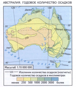 Since the 1980s, an ozone hole is observed over Australia, with which a sharp increase in the incidence of melanoma among the white population of the mainland is associated. In the subequatorial climatic belt, the summer monsoon is clearly pronounced (up to 70% of precipitation) and the winter dry season. Characterized by constantly high air temperatures - up to 20-28 ° C; Before starting rain - up to 40 ° C. On the north coast, tropical hurricanes are sometimes collapsed; In 1974, Hurricane Tracy destroyed G. Darwin. In the tropical climatic belt, two sectors are distinguished: continental dry desert and semi-desert (from the coast of the Indian Ocean in the West to the Great Waterproof Ridge in the East) and the coeclastic (on the east coast and the coastal mountain slopes) with a hot wet summer and warm, less wet winter. Mountains, although low, impede the promotion of the mainland of wet air masses, and precipitation falls mainly on the coast and eastern slopes of the ridges. In the central part of Australia, where the continental tropical air dominates during the year, and the annual amounts of precipitation do not exceed 250 mm, a tropical desert climate (with the fierce in Australia a large sandy desert). The average summer air temperature is 28-30 ° C, although often rises to 40 ° C (absolute maximum 53.1 ° C), winter 12-20 ° C (there are sharp cooling). Annual and especially daily temperature amplitudes reach 35-40 ° C. The precipitation usually falls out in the form of short rains coming with the northern winds in the summer and with southern - in winter. Relative air humidity 30-40%. In the southwestern part of the mainland, as well as in the southeast, in the Murray River basin, is the Mediterranean type of climate with hot dry summer and cool wet winter. On the eastern slopes of a large waterproof ridge and in the north of Tasmania Island, the climate is monsoon, evenly wet (up to 1500 mm of precipitation per year). The average temperature of the winter months is 5-10 ° C. In the Australian Alps, large amounts of precipitation are combined with significant seasonal fluctuations in air temperature (in the mountains there are frosts up to -20 ° C). Plain Nallarbor receives very little precipitation (up to 250 mm) and is characterized by significant seasonal temperature differences (in summer 22-24 ° C, in winter 10-12 ° C). The southern part of the island of Tasmania comes into a temperate belt. The constant effect of Western air transfer causes the abundance of precipitation on the west coast and the slopes of the mountains. Seasonal differences in temperature (15 ° C in summer and 10 ° C in winter) are insignificant; In the mountains of frost to -7 ° C.
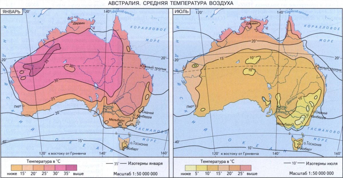
Inland waters. For Australia, a weak development of surface runoff is characterized (see the River Stoke map). The share of the Australian rivers is only 350 km 3 (less than 1% of the total flow of the Earth rivers), and the thickness of the flow layer is about 50 mm per year (6 times less than in Europe, 8 times less than in South America). The most developed river network on the island of Tasmania, where the rivers are full on the course of the whole year, flow from the mountains, violent, thresholds and have large hydropower reserves. Australia's nutrition is almost exclusively rain. Only on a wet eastern outskirts, the mainland flows inaccessive short-flowing rivers, and a layer of drain increases to 400 mm per year. About 10% of the territory has stock in the Pacific Ocean. Almost 30% belongs to the Indian Ocean basin, 60% refers to the field of internal flow. The main watershed is a large waterproof ridge. With its western slopes, the largest and largest rivers of Murray (Marri) flow with the influx of Darling, which constitute the largest river system of the mainland. Murray (length 2570 km) In short, Darling (the longest River Australia is 2740 km), but the most complete (along with the influx of Marrambiji) River Australia. Pool area of \u200b\u200bthese rivers 1057 thousand km 2.
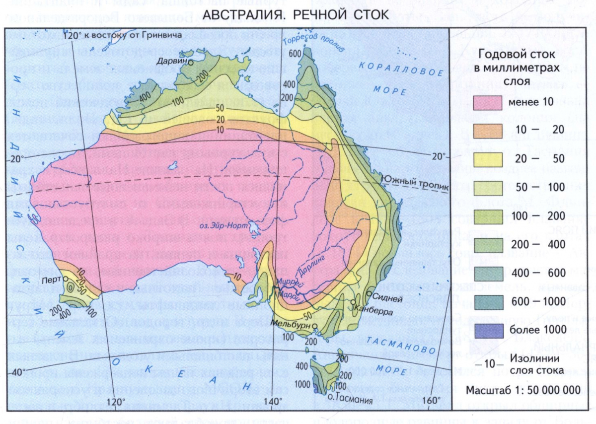 The Murray Darling rivers have a lot of economic importance, their water is used in hydropower and for irrigation of fertile, but arid lands. In 1974, a project was carried out on the transfer of part of the runoff of the Snowui River River to the Murray River Pool. In the direction of Coral and Tasmanov, the seas run down short, fast, spoiled and finest rivers with a clearly pronounced summer maximum: Fitzroy, Berdekin, Hunter, and others. Some rivers are shipping: Clarence is 100 km from mouth, Hoxbury 300 km. The largest rivers of the northern part of Australia - Flinders, Victoria and Horde, flowing into the Arafur and Timor seas, shipping in the summer in the lower current. They often come out of the shores during the summer monsoon rains, and in winter it is weak narrow watercourses, in the upper reaches, drying. The rivers of the south-western part during the dry summer season are converted into chains of shallow reservoirs. In deserted and semi-desert areas, a network of dry beds is preserved, called the "Creams" in Australia, filled with rainwater for a very short time. Especially a thick scream network (Cooper-Creek, Diamantine, Ayre Creek, etc.) on the central plain, where they are sent to the selfless breathing Lake Air North. Plain Nallarbor, devoid of periodic watercourses, has an underground water network with a runaway towards the Big Australian Bay. On the Horde River, the largest in Australia in the area of \u200b\u200bthe RF Argail reservoir (about 800 km 2) was created.
In Australia, many lakes and ancient lakes Kotlovin. Most of the lake is light and salted, many are filled only after rains. The largest Lake Air-North in the most wet years reaches the area of \u200b\u200b15 thousand km 2, in the dry period decays to shallow reservoirs separated by salt marshes. Torrens, Gardner, Frome, and others include major saline lakes. In the western part of Australia, numerous faceless lakes form the plain of salty lakes. On the Gordon River (Tasmania Island) is the largest in Australia in terms of the volume of Gordon reservoir (11.8 km 3). Especially great in Australia resources underground, including artesian waters, pools of which occupy one third of the mainland territory (about 2.5 million km 2). 6500 artesian wells in more than 30 artesian basins give water for industrial, agricultural and household purposes. The largest of them: a large artesian pool, Murrasky, Morton Clarence, Yukla, Office, Georgina, Cunning, Karnarvon, Perth, Plasterland. Due to severe mineralization, not all groundwater is suitable for use.
Soil. For the most part of Australia, in the inner arid and semi-sirid areas, the primitive soils of tropical and subtropical deserts and semi-deserts are common. In Western Australia, crubstone soils predominate and semi-rained ferrous concrete sands (the products of ancient soil), on the plains of the central lowland - sand-clay and clay soils, around the saline lakes - salt marshes. As the moisturizing and the degrees of lateritization of the soil thickness, the premissive soils of the desert are replaced by reddish-brown semi-desert and red-brown soils of Savann. In the subequatorial belt have been formed apodoline red and apodoline varnish soils, in subtropical - are characteristic of gray-brown (often salon-taking) and brown soils. In the mountains under the forests, red-yellow ferrallitic, and on the island of Tasmania - brown and yellow-brown forest soils. Often meet, especially in subtropics, so-called twisted soils, having a buried profile of an ancient soil. Australia is the mainland of ancient weathering, varnishing in the north and west, silica in the south-east. In extensive ancient lakes, dark color fusion soils were formed in the extensive ancient lakes and widgets of the drain. All these types of soil are poor by biophilic elements and require significant doses of fertilizers. Among the destructive processes, secondary salinization, water erosion and deflation are the most common.
Vegetation. The vegetable and animal world of Australia is distinguished by antiquity and high degree of endemism. The Australian Floral Kingdom, which belongs to Australia and Tasmania, does not have equal in the number of endemics: out of 12 thousand species of higher plants endemic 80% (for example, about 500 species of the type of acacia and about 500 species of the Eucalyptus of the most typical representatives of Australian flora). Along with this, there are representatives of childbirth and families common in South America (South Beech), South Africa (protein) and in Southeast Asia (Ficus, Pandanus, etc.). Australia presents the formation of tropical forests, wet and dry sclerophilic forests, tropical and subtropical edgichests, various types of shrubs, savannah, semi-deserts and deserts (see the map Geographic belts and zones). A large role in their distribution plays the degree of moisture of the territory. On the Peninsula Arnhem Lend, on low-lying coastal plains there are mangroves. Northern and oriental retisions are busy with rooted wet tropical evergreen forests. Their composition is dominated by giant eucalyptus, ficuses, palm trees, pandanus. According to the valleys of the rivers, the wet rainforest penetrates the zone of wet savannas with rare groups of trees (eucalyptus, bottle, acacia). South, on the eastern outskirts of Australia, climbing the wet eastern and southeastern slopes of a large waterproof ridge, grow thick tropical and subtropical forests (from eucalyptus, tree ferns, representatives of the Callitrix clan). With the increase in the continentality of the forests are replaced by tropical palpals, shrub thickets and savannahs.
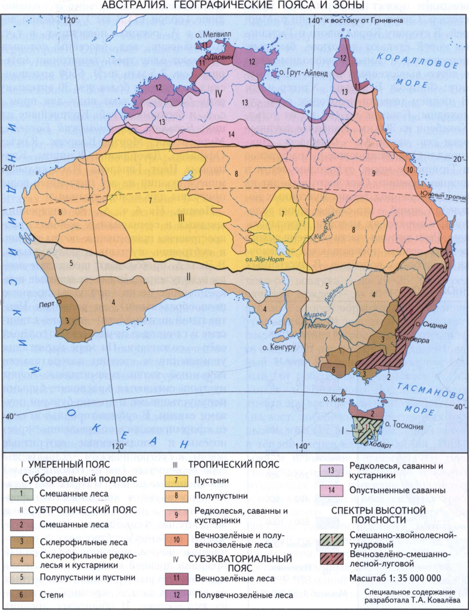 In the internal areas of Australia, thick, almost impassable prickly thickets of low shrubs are common (low acacia and shrub forms of eucalyptus), as well as extensive sandy (large sandy desert, large desert Victoria, Simpson, etc.) Desert with typical high turf cereals (Spinifex) . There are rocky or clay-salt (Gibson) desert with saltworn-shrubberry vegetation. The deserts and semi-deserts occupy about 70% of the territory. In the south-west of Australia, in the Western slopes of the Darling Ridge, monotomicated forests from the eucalyptus of the border - Yarah (height up to 150 m) grow. On the island of Tasmania, wet mixed (eucalyptus, southern beats, tree ferns) are common on Western out-of-ground outdoors, southern beats, tree-like forests, on the eastern slopes. Forests, including artificial planting from American pine rays, occupied (2000) about 5% of the mainland territory, including wet tropical forests less than 0.5%. In the guise of modern landscapes of Australia, a huge role is played by the plants (food, fodder and technical), in significant areas, replaced natural vegetation. Alien species of plants (Bizonova Grass, Cryptostic, Giant Mimosa, Shaud, Spification, etc.) became malicious weeds.
Anthropogenic landscapes differ significantly from natural. About 65% of the territory is involved in the scope of economic activity. About 40% of all forests are reduced, including 75% of wet rainforests (individual arrays are preserved in the East), more than 60% of the wetlands of the coastal zone in the south and east of Australia are lost. The deepest changes have undergone natural landscapes subtropical belts. Almost all coastal plains and intermountain basins are converted into cultural pastures, gardens and plantations. To the west of the large waterproof ridge predominate pasture-arable land. The largest arrays of irrigated lands are focused here and the largest amount of grain (the so-called wheat-wardrobe belt), fruits, vegetables, etc. are produced. Fields, gardens, plantations and vineyards are combined with cultural pastures, also irrigated. Almost unchanged landscapes with shrub and semi-desert formations are preserved on the plain nullarbor. In Western Australia within subtropical belt Pastures and arable land are widespread, in the eldest southwest - forestry, on the south-west coast - arable and garden plantation landscapes, mainly around the city of Perth and other cities. The remaining territories (except for protected lands) are engaged in pasture grounds. In the main agricultural areas of the soil are subject to the processes of secondary salinization and accelerated erosion. On the island of Tasmania, mainly in the eastern part, pastures predominate, pasha and garden plantative anthropogenic landscapes.
Animal world Australia and the adjacent islands is so kindly that it stands out in a special Australian zoogeographic area. For fauna, the poverty of species composition, endemism and the presence of relics are characteristic. There are only 235 species of mammals, 720 - birds, 420 - reptiles, 120 - amphibians (90% of vertebrate types - endemics). The region is distinguished by the uniqueness of mammals: only here the most primitive representatives are inhabited - single-pass (egg-standing wall-building, echidna and prohhidn). Particularly diverse samples (more than 10 endemic families): predatory (silent mice, sample rats, silent cunits); Temporary amusements (one species - in the south-west of Australia); sample moles (in the sandy deserts of Central Australia); Lazaging bags - poses (in wet tropical and subtropical forests lead, mainly the woody lifestyle); coal (one species, a short bear, inhabits eucalyptus forests); Wombatovy (samplers); Kangarovy (Kangaroi Rats, Wallaby, Real Kangaroo), found in various natural landscapes (deserts, forests, etc.).
On the island of Tasmania, two representatives of the stembed, absent on the mainland, are a sample wolf and a sore devil. The highest mammals of Australia are represented only by two squads - manochable (bats) and rodents (beaver rats, rabbit rats, kenguro mice are all from the mouse family). The birds are very diverse: Ema, Kazaire, Larochvost, Paradise birds, various types of parrots and pigeons (including a crowded pigeon), Medosos, weed chickens. On rivers and lakes, waterfowl nests are nesting: black swan, geese, etc. Among the reptiles there are sideways, moloch, aspids. In wet rainforests, endemic machines, termites, butterflies and beetles are numerous. Inner waters are rich in fish, including endemic species (two-way Fish Rogozub). The crocodile Johnson and the turtle serpentine. From predators - Dingo and Fox dog. Numerous rats, camels, rabbits (exterminated herbal covers on extensive squares), brought from old light as pets or hunting objects. In the southern part of Tasmania Island, there is a typical representative of the Antarctic fauna - a small penguin. As a result of anthropogenic effects, 10 out of 144 types of compound animals and 8 out of 53 extinct local species rodents. In connection with the cutting of forest arrays, many types of animals were under the threat of disappearance, about 17% of mammalian species were made to the Red Book of IUCts. The brought representatives of the Faun of other continents caused great damage to nature.
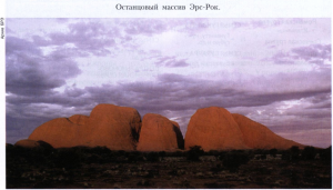 Particularly protected areas. In Australia, there are more than 4.5 thousand specially protected natural areas of various categories, occupying about 8% of Australia's area, including about 500 national parks and nature monuments (among them the symbol of Australia, the remaining array of ere rock). 12 national parks are included in the global network of biosphere reserves, 15 are included in the World Heritage List. In 1879, the first South Wales was created in the state of New South Wales, the Royal National Park, located 32 km south of Sydney. The most significant is the largest Marine Park in the world. Big barrier reef (area of \u200b\u200b500 thousand km 2) and Cockada National Park.
History of geographical research. Even in ancient times, it was assumed that in the southern hemisphere there is an extensive mainland, stretching to the polar latitudes. Ptolemy (2 century), and then scientists late Middle Ages showed on the maps of the continent south of the Tropic Capricorn and called it Terra Australis Incognita (unknown Southern Earth). It is believed that the Dutchman V. YANSZON was the first European, landed in 1606 to the Australian Coast into the Bay of Carpenary. In the same year, Spaniard L. Torres opened the strait called him name. In the 1620s, Dutch navigators Ya. Krastenex, V. Van Colter, F. Taisen and P. Nitits opened the Arnhem Lend Peninsula and Cape York, as well as the western part of the South Coast of Australia. By 1640, Dutch sailors visited Western, North and South coasts. In 1642, Dutchman A. Tasman passed south of the mainland and opened the island, called the land of Wang Dimemen. Later, this island was renamed in honor of the discoverer and became known as Tasmania. In 1644, Tasman, moving along the northern coast of Australia, proved that the open land in size is much less than supposed, and does not enter cold polar latitudes. Western Australia received the name of New Holland.
In 1770, the English navigator John Cook opened the eastern coast of Australia and announced the new land of the Colonian of Great Britain, calling her new South Wales. In 1778, the first English calender colony was founded (on the site of modern Sydney). In 1798, the Englishman J. Bass went around the island of Tasmania and an emergency on the brand of the strait, later called him named. His compatriot Captain of the Royal Fleet M. Flinders in 1797-1803 made a swim around the mainland around everything, and on his maps (from 1814) there was a modern name - Australia.
Study of the internal parts of the mainland in order to search for land suitable for pastures in the 19th century. The first expedition, overcoming the blue mountains, headed in 1813. Blysland. The Englishman Ch. Stretch opened (1829-30) the Darling River and descended on the Murray River to the mouth. During the English expeditions in 1830-45, T. Mitchell discovered extensive fertile plains to the west of a large waterproof ridge; E. Eyre Angered on Lake Torrens and North Air, Flinders and Gingle Ridges, in 1841 passed along the southern coast to Albany. In 1840, the Polish traveler P. Stshhetsky opened the highest vertex - Mount Kosyushko. In 1844-45, the German traveler L. Leihhardt passed along a large waterproop to the Bay of Carpenary, and then came to the West coast of the Arnhem Lend Peninsula, where the city of Darwin is now located. From the north to south, the British expeditions R. Broke and Willis (1860) and J. Stewart (1862); From east to west in the 1870s - English expeditions J. Forrest, E. Giles, P. Warberton. By the end of the 19th century, all major geographical objects of Australia were applied to the map.
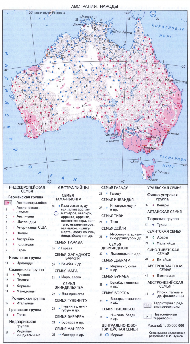 Peoples. The indigenous population of Australia is Australian-Aboriginal, the ancestors for the first time appeared on the mainland about 60 thousand years before our era (a person's find from Lake Mungo, 62 thousand years ago). From the end of the 16th century, Australia begins to master by Europeans, in the 17th century - mostly Dutch, since the end of the 17th century - the British. As a result of the colonization of Australia, the main population of modern Australia has emerged from the British Islands - Angloavalist.
In the 19th century, especially after the "gold fever" of the 1850s and 1960s, immigrants from Germany, the Netherlands, Greece, Italy, China, USA, Canada appeared in Australia. Immigration in Australia continued in the 20th century, including from Malaysia, Philippines, India and Pakistan. After the 2nd World War, thousands of refugees and displaced persons were in Australia, after the Hungarian events of 1956 - about 14 thousand Hungarians, after the Czechoslovak events of 1968 - about 6 thousand Chekhov and Slovaks, in the 1970s - about 15 thousand refugees from Lebanon, about 70 thousand - from Indochina. Now in Australia there are about 100 ethnic groups speaking, according to different estimates, on 75-100 languages, not counting English and aboriginal languages. About 25% of the population of Australia has unbelinarian ethnic roots. So, the number of Maltesers in Australia exceeds the Maltese population of Malta. Ethno-territorial and professional groups have developed: the Italians farmers in the new South Wales, the Germans in the Varosa Valley; The cities have large Italian, Greek, Chinese, Vietnamese, Russians and other communities.
See Australia map. Peoples. See also the section Population in Article Australia (State).
LIT.: Light Ya. M. History of opening and research of Australia and Oceania. M., 1966; Learmonth A., Learmonth N. Regional Landscapees of Australia. L., 1972; Kucm A. Australia and Pacific Islands. M., 1980; Countries and peoples. M., 1981. T. 6: Australia and Oceania. Antarctica; Magidovich I. P., Magidovich V. I. Essays on the history of geographical discoveries: at 5 t. M., 1982-1985; Physiography mainland and oceans. M., 1988; Drozdov N.N. Flying boomeranga. 2nd ed. M., 1988; Hermes N. Explore Wilderness Australia. L., 1997; Smith R. M. National Geographic Traveler. Australia. Wash., 1999; Amazing Facts About Australian Landforms. L., 2000; O'Byrne D. Australia. 10th Ed. Melb.; L., 2000; Hain V.E. Tectonics of continents and oceans (year 2000). M., 2001.
N. A. Bozko (geological structure and minerals), T. A. Kovaleva.
In structural terms it is a system of depression, made by sedimentary strata, which overlap deeply immersed crystalline rocks. Along the periphery of lowlands, and in places and within the lowlands themselves there are ridges of Mount Lofty, Flinders and a large water-seated. These are the remnants of ancient mountain structures, around which younger sediments have been deposited. The relief creation and precipitation shortage is the most vivid features of the lowlands. They are very rarely lifted above 300 m above U.M., and in many places they do not reach 150 m. The highest terrain is where lowlands are suitable for the Flinders Range and the Mountains of Eastern Australia. Territory area of \u200b\u200babout 10.4 thousand square meters. km around lake Air, including the lake itself, is located below sea level. The surface of the lowland is mostly monotonous and visible; Over a few tens of meters, only flat-terrible and sharp erosion remains are rising. Most of this region annually receives less than 380 mm of precipitation, and in the drying area of \u200b\u200bAustralia - in the vicinity of Lake Air - the average annual amounts of precipitation do not exceed 125 mm. Low waters are separated by the lowlands on three main basin. In Central Queensland, a fuzzy pronounced water-income ridge stretches from the Mountains of Eastern Australia to Western Plateau, referring to the plain near the shore of Karpenaria's Bay from the Lake Eir. Next to the east of the same low watershed ridge separates the Murree and Darling pool.
Color and smooth carpentarian lowland has a clear border in the West with a crossed area of \u200b\u200bCloncarri - Mount Isa, folded strongly mineralized rocks, and in the east - with the mountains of East Australia. At a distance of approximately 480 km south of the Bay of Karpenaria, the southern border of the plain is low watershed ridge. Gilbert River, Flinders, Likehardt, having a gentle longitudinal profiles, fall into the bay. During flooding, large areas of the plain are flooded. The soil of the region favors the growth of eucalyptus edded and meadows. Within this plain, the greatest amount of precipitation falls compared to any other part of the central lowlands. At the same time, on the watershed, the average annual precipitation amount is 380 mm, and on the shore of the Karpenaria bay - 970 mm. The coastal plain is mainly used under pastures for cattle.
The south of the waterproof lowland ridges cover the Southern Queensland and the northeastern part of South Australia. The greatest length from the north to the south is approximately 1130 km, and from west to east - 1200 km. All this extensive territory is characterized internal flow And divided into several catchment pools. The largest of them is the pool of Lake Air of 1143.7 thousand square meters. km. It includes most of the desert Simpson and feeds on numerous periodically drying rivers. The slopes here are so small that the rivers literally melt on the surface, and then appear again, sometimes under a different name. Thus, Thomson and Barca, beginning in the mountains of Eastern Australia, give rise to Cooper, Diamantine with the main tributaries Hamilton and Georgina turn into Warberton. Rarely stock from Western Plateau can reach Lake Air through the Makakuba and Nils River. Typically, these watercourses are a labyrinth of dry beds bounded by eucalyptus thickets. Randomly encountered deep segments Rolls form valuable constant waterborne funnels. There is no stock in such ruses every year. But when it happens, a bond with tropical rainseed precipitates is sometimes very intense, elevated areas located to the north and east. The floods formed are widely dissipated in the territory, and there may be a week before the flow of water can go downstream. Such floods determine the abundant growth of herbs in pastures, but this is only a temporary phenomenon for which it is impossible to count on. The lowlands located at the junction of South Australia and Queensland are used under pastures, and the area around Lake Air actually remains in a natural state. A significant part of this area is part of the Great Artesian Basin, and there is a pasture farm provided by water.In the southeastern part of central lowlands, there is a pool of Murree and Darling, which is the largest water collection system of the mainland. This is an extensive base area drained by rivers with a very irregular flow. Despite the large area of \u200b\u200bthe drainaged lands (1072.8 thousand square meters) and a greater length of the main rivers, the flow volume in this system is small. Murray and Darling rivers, originating in the mountains of Eastern Australia, flow to the west and southwest through lowland areas where there are few precipitation, and evaporation is great. These factors in combination with intensive mearaning of the bed leads to a decrease in costs for most of the flow of rivers.
The territory drained by the Darling River is mainly used under the sheep's pastures, but in the eastern parts of the sheep flows are combined with pools. The Rivein region, located between the rivers Laclan and Murray, along with the lands along the bottom course of Murrey and his tributaries in Victoria - the most important area of \u200b\u200banimal husbandry and grain farm Australia. The relief and soils are conducive to carrying out large-scale irrigation. The most significant arrays of irrigated land are concentrated between the rivers of Marrambiji and Laclan (Marrambiji Irrigation System), in the Murrey Basin, located in the new South Wales (Rivein Irrigation System) and Victoria (Goulburn-Kampace-Loddon system). In addition, there are several small ranges of irrigated land in the lower reaches of Murree. In these areas, fruits, grapes and vegetables are raised in these areas. With the introduction of the Snow Mountain Hydrophenesystems, an additional flow of flow into the Murree pool and Marrambiji was carried out, and they managed to expand the area of \u200b\u200birrigated land. However, the water is still not enough to irrigate all lands.
The relief of Australia is dominated by the plains.
About 95% of the surface does not exceed 600 m above sea level. The modern relief of Australia largely inherits the features of an ancient relief that has not experienced sharp tectonic movements from the Precambrian time. Large (Western and Central) Part of Australia belongs to the field of an ancient Australian platform, which also includes the North, Western and South Underwater continuation of the mainland, the Arafur Sea and the southern part of New Guinea Island. The eastern outskirts of Australia is an East Australian folded belt, developing throughout the proterean and plywood. In the relief, it is represented by a large watershed ridge (medium, with flat vertices, steep, strongly dissected Eastern slope and hollow-speed Western, turning into hilly foothills). In the south, in the Australian Alps, the highest point of Australia - Mount Kosyushko, 2230 m.
The relief of Australia is simple enough. It can be conditionally divided into three parts - West Australian Plateau, central lowlands and East-Australian mountains. Each of these parts has its own characteristics and unique form of relief.
Most of the Australian platform occupies Western Australian Plateau, corresponding to geological terms of Western Australia. The edges of West-Australian plateaus often rise above 1000 m in the form of bilying arrays, flat-terrestrial remaining mountains and small. Maximum heights they reach in the east within the folding-block mountains Masgraiv and McDonnell, which are based on the Precambrian folded structures. In the southeastern part of the plateau, the ancient lake hollows, which are currently transmitted to clay-salt plains. In the south of West-Australian plateau, the largest Karst area of \u200b\u200bAustralia is allocated - plain nullarbor, folded by limestone.
In the zone of the meridional deflection of the foundation of the Australian platform, the region of Caledonian folding, presented in the relief of the lowland strip (central lowland). They are a bit raised above sea level (on average 150 m), although there are separate sections that have a mark below the sea level (Oz. Air - 12 m). 100 million years ago Center. The lowland plunged under the ocean level and a long time was a strait separating the western part of Australia from Eastern. In the east, the central lowland increases to 300-400 m, moving to the dances (foothills).
The eastern part of the mainland from P-ov Cape York in the north to Tasmania in the south is occupied by the East Australian folded area. In the relief of this folded area corresponds to a large waterproof ridge. The eastern slopes of the mountains, cut off by discharges, are steep, western - hollow-speed, gradually turning through the downce zone in the plains of Central Australia. The mountains of the northern part are low and medieval, elongated in the meridional direction, broken into separate flat-master ridges. The southern part of the large waterproof ridge is characterized significantly greater height and lower. The meridional direction of the ridges is preserved within the state of the new south. Wales, in the Victorian Mountains, it changes dramatically on a latitudinal one. Mountains are folded by Paleozoic and mesozoic crystalline rocks, sedimentary rocks, as well as volcanic rocks. Basalt outposts form the Liverpool ridge, are found in the New Ingland Mountains. There are many deep karst caves in the mountains, the blue mountains are especially highlighted (up to 1200 m), but they are cut through deep canyons, they are very cool in the east and steps to west. Extreme southern part of the blue mountains - Victorian Alps. They are elongated in the latitudinal direction in the form of a plateau and individual arrays with the highest high height of 1900 m. They bagely bay Port Philipp. A large height of a large waterproof ridge reaches in the Australian Alps (Snow Mountains).