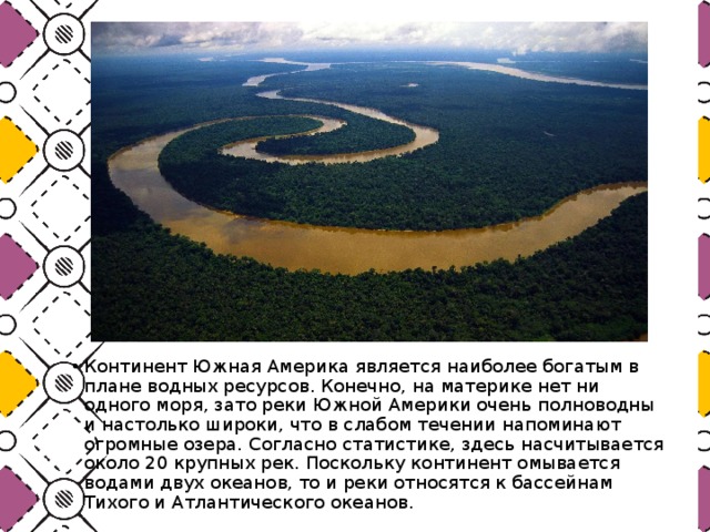
South America receives the highest amount of precipitation compared to the rest of the continents of the Earth. This created good conditions for the emergence of an abundant system of lakes and rivers. They play a serious role in various aspects of the life of mankind and the Earth, among them there is also a tourism component. By the way, some rivers and lakes in South America contain virtually no water. But for travelers, this does not make them less attractive. Even, rather, on the contrary - today many people are interested in
The lakes of the mainland attract a lot of travelers every year. People come from all over the world to see some of them.
maracaibo
Many tourists today are interested in exploring South America. Lakes also attract their attention. The largest of them is Maracaibo. But if it is considered as a geographical formation, it has signs of a bay. Its main feature is quite scary and unique a natural phenomenon These are Catatumbo lightning bolts.
At the point where the Catatumbo River flows into it, lightning is observed. Here they strike almost continuously for 9 hours. Almost half of the nights here are illuminated by very bright flashes, they can be seen at 400 km.
This phenomenon is explained by the collision of methane rising up. It comes from local swamps, as well as from the Andes, from descending air currents. At this moment, a potential difference is formed in the clouds, which is constantly discharged in the form of celestial electricity.
Peach Lake
red lake
Considering the lakes of South America, it is impossible not to highlight the Red Lake. This is often referred to as Laguna Colorado. This lake is located in the reserve called Eduardo Avaroa in Bolivia, at an altitude of almost 4200 meters. 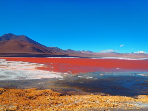
Its uniqueness is based on two factors.
- First: algae “live” in this place, which produce substances that reliably protect them from ultraviolet radiation, and therefore change the shade of water. The lake, depending on the temperature and time of day, can acquire different shades - from scarlet to dark purple.
- Next: this is a place where thousands of flamingos settle, among which there are representatives of the rarest species.
Uyuni
Some lakes in South America are characterized by a small amount of water. So in Uyuni, she appears extremely rarely. This is the world's largest dry salt lake, which was formed in the prehistoric period by the transformation of several reservoirs at once.
This giant salt marsh, with a total area of about 10.5 thousand km², is located in Bolivia, in the south of the Altiplano, a desert plain. It contains large reserves of salt, lithium chloride.
For travelers who come here during the rainy season, the lake gives an amazing experience. At this time, there is a feeling of driving or walking on a huge and smooth, which stretches over vast distances. 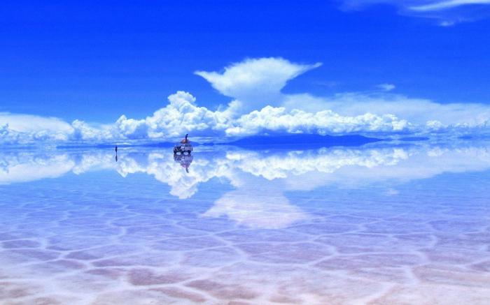
There are many beautiful lakes on the mainland. Some of them are located in hard-to-reach regions, others are "tourist untwisted attractions." Like it or not, seeing the large lakes of South America is worth every traveler looking for unforgettable sensations and vivid impressions.
The features of the relief and climate of South America predetermined its exceptional wealth of surface and ground waters, the huge amount of runoff, the presence of the deepest river in the world - the Amazon. Occupying 12% of the land area of the Earth, South America receives about 2 times more (1643 mm) of the average amount of precipitation per unit of the entire area. The total river runoff is 27% of the total runoff of the Earth, the average runoff layer (58 cm) is also almost 2 times the average value for the entire land. But the amount of runoff fluctuates sharply across the mainland - from a few mm to hundreds of cm. The rivers between the ocean basins are also extremely unevenly distributed: the Pacific Ocean basin is 12 times smaller than the Atlantic basin (the watershed between them runs mainly along the Andes ridges); in addition, about 10% of the territory of Yu. A. belongs to the region internal runoff, crossing the mainland from the Gulf of Guayaquil through the Central Andean Highlands to the southern Pampa. Rain-fed rivers predominate, in the extreme south - also snow-glacial.
The largest layer of the average annual runoff of 150-400 cm (up to 90% of precipitation) reaches in southern Chile, which is explained not only by the abundance of precipitation, but also by the steepness of the slopes, low evaporation and ice reserves in the upper reaches of the rivers, which cause summer floods, including and at the "transit" rivers of Patagonia; the share of underground feeding of the rivers of the South Andes is no more than 20-25%. The runoff is just as great (for some rivers even up to 800 cm) in western Colombia, but rainfall and summer-autumn flash floods predominate there; underground runoff increases up to 40%. The runoff characteristics of the Amazon are similar, decreasing in its central and southern parts to 40-60 cm. The regime of large rivers, like the Amazon itself, depends on the rainy season in the upper and middle reaches of its tributaries. On the well and more or less evenly moistened outskirts of the Brazilian and Guiana plateaus, the average annual runoff is also 40-60 cm (in some places up to 150 cm) with a share of underground runoff up to 50%. In the interior regions of the Brazilian Plateau, the runoff decreases (up to 5 cm in the northeast) and becomes extremely uneven: violent summer floods are replaced by a sharp decrease in water discharge in winter, up to the drying up of small streams. The flow regime is similar in the flat territories of the subequatorial and tropical belts with rain-fed rivers (Llanos-Orinoco, Beni Mamore, Gran Chaco plains). A pronounced seasonality in precipitation leads to variability in runoff (the average runoff decreases from 50–80 to 15–20 cm) and river regimes: in the winter of the corresponding hemisphere, runoff stops in places and even large watercourses (Rio Bermejo, Rio Salado, etc.) break into separate stretches with saline waters, in summer the floods flood vast spaces; The flow regulators of the rivers of Paraguay and Parana are the swamp-lake lowlands of the Pantanal and the Laplat lowland. The smallest flow (3-5 mm) is confined to the desert tropical west of South Africa, where even melted snow water from the highlands accumulates in foothill plumes and tectonic depressions, increasing the share of underground feeding of episodic rivers to 50% (only the Loa River has a constant flow in Ocean).
A large number of precipitation brought from the Atlantic, vast plateaus gently sloping down to huge lowlands and plains that collect runoff from the adjacent slopes of the Andes, contributed to the formation of large river systems in the Andean East of South Africa: the Amazon, Orinoco, Parana, and Paraguay. Uruguay; in the Andes, the largest is the river system. Magdalena, flowing in the longitudinal depression of the humid Northern Andes. Only lowland rivers are suitable for navigation. The mountain rivers of the Andes and plateaus, replete with rapids and waterfalls (Angel, 1054 m, Kaieteur, 226 m, Iguazu, 72 m, etc.), as well as full-flowing streams of constantly wet plains, have a huge hydropower potential (over 300 million kW).
Large lakes, mainly of glacial origin (end basins), are concentrated primarily in the Patagonian Andes (Lago Argentino, Buenos Aires, and others) and in southern Central Chile (Llanquihue, and others). In the Central Andes lies the highest of the large lakes of the Earth - Titpkaka, there are also many residual lakes (Poopo and others) and large solonchaks; the latter are also typical of the depressions between the Pampina sierras (Salinas Grandes and others). Large lagoon lakes are located in the north (Maracaibo) and in the southeast of South Asia (Patus and Lagoa Mirin).
The largest rivers in South America
|
Name |
Length in km |
Basin area in thousand km |
|
Amazon (with Ucayali) |
||
|
Amazon (with Marañon) |
||
|
Paraná (with Rio Grande and La Plata Estuary) |
||
|
Madeira (with Mamore) |
||
|
San Francisco |
||
|
Japura (with Kaketa) |
||
|
Tocantins |
||
|
Paraguay, river |
||
|
Rio Negro |
||
|
Uruguay, river |
||
|
Magdalena |
Amazon river
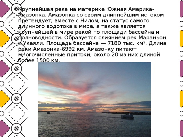
The largest river in South America is the Amazon. Most of its basin lies south of the equator. The area of this most extensive river basin in the world is over 7 million km 2, the length of the river from the main source (the Marañon River) is 6400 km. If, however, Ucayali and Apurimac are taken as the source of the Amazon, then its length reaches 7194 km, which exceeds the length of the Nile. The flow of water in the Amazon is several times higher than the flow of all the largest rivers in the world. It is equal to an average of 220 thousand m 3 / s (the maximum flow rate can exceed 300 thousand m 3 / s). The average annual flow of the Amazon in the lower reaches (7000 km 3) is most the flow of all South America and 15% of the flow of all the rivers of the Earth!
The main source of the Amazon - the Marañon River - begins in the Andes at an altitude of 4840 m. Only after confluence with the first major tributary - Ucayali - within the plain, the river receives the name Amazon.
The Amazon collects its numerous tributaries (more than 500) from the slopes of the Andes, the Brazilian and Guiana highlands. Many of them are over 1500 km long. The most numerous and largest tributaries of the Amazon are the rivers of the southern hemisphere. The largest left tributary is the Rio Negro (2300 km), the largest right and largest tributary of the Amazon is Madeira (3200 km).
Part of the tributaries, washing away clayey rocks, carry very muddy water (“white” rivers), others, with clear water, carry dark from dissolved organic substances (“black” rivers). After flowing into the Amazon Rio Negro (Black River), light and dark waters flow in parallel, without mixing, for about 20-30 km, which is clearly visible on satellite images.
The width of the Amazon channel after the confluence of Maranyon and Ucayali is 1-2 km, but downstream it increases rapidly. At Manaus (1690 km from the mouth) it already reaches 5 km, in the lower reaches it expands to 20 km, and at the mouth the width of the main channel of the Amazon, together with numerous islands, reaches 80 km during the flood. In the western part of the lowland, the Amazon flows almost at the level of the banks, in fact, without a formed valley. To the east, the river forms a deeply incised valley which contrasts sharply with the watershed.
The Amazon Delta begins about 350 km from the Atlantic Ocean. Despite its ancient age, it did not move into the ocean beyond the boundaries of the native shores. Although the river carries out huge masses of solid material (an average of 1 billion tons per year), the process of delta growth is hindered by the activity of the tides, the influence of currents, and the lowering of the coast.
Downstream of the Amazon big influence its regime and the formation of coasts are affected by ebbs and flows. The tidal wave penetrates more than 1000 km upstream, in the lower reaches its wall reaches a height of 1.5-5 m. The wave rushes against the current at great speed, causing strong excitement on sandbanks and banks, destroying the coast. Among the local population, this phenomenon is known under the name of "pororoka" and "amazunu".
The Amazon is full of water throughout the year. Twice a year the water level in the river rises to a considerable height. These maxima are associated with rainy periods in the northern and southern hemispheres. The greatest flow in the Amazon occurs after the rainy season in southern hemisphere(in May), when the bulk of the water is carried by its right tributaries. The river overflows its banks and in the middle reaches fills a huge territory, creating a kind of giant inland lake. The water level rises by 12-15m, and in the Manaus region, the width of the river can reach 35 km. Then comes a period of gradual decrease in water flow, the river enters the banks. The lowest water level in the river is in August and September, then there is a second maximum associated with the summer rains of the northern hemisphere. On the Amazon, it appears with some delay, around November. The November maximum is significantly inferior to the May one. In the lower reaches of the river, two maxima gradually merge into one.
From the mouth to the city of Manaus, the Amazon is accessible to large ships. Vessels with a fairly deep draft can penetrate even as far as Iquitos (Peru). But in the lower reaches, due to the tides, the abundance of sediment and islands, navigation is difficult. Deeper and accessible to ocean vessels is the southern branch - Para, which has a common mouth with the Tocantins River. On it stands a large ocean port of Brazil - Belen. But this branch of the Amazon is now connected with the main channel only by small channels. The Amazon with tributaries is a system of waterways total length up to 25 thousand km. The transport value of the river is great. For a long time it was the only route connecting the interior of the Amazonian lowland with the Atlantic coast.
The rivers of the Amazon basin have large reserves of water energy. Many tributaries of the Amazon, when entering the lowlands, cross the steep edges of the Brazilian and Guiana highlands, forming large waterfalls. But these water resources are still very poorly used.
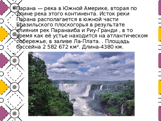
Parana and Uruguay rivers
The second largest river system in South America includes the Parana River with Paraguay and Uruguay, which have a common mouth. The system got its name (La Platskaya) from the eponymous giant estuary of Parana and Uruguay, reaching 320 km in length and 220 km in width at the mouth. The basin area of the entire system is more than 4 million km 2, and the length of the Parana, according to various sources, ranges from 3300 to 4700 km. The sources of Parana - Rio Grande and Paranaiba - are located in the Brazilian Highlands. Many other rivers of the system also begin there. All of them in the upper reaches are full of rapids and form several large waterfalls. The largest waterfalls are Guaira 40 m high and 4800 m wide on the Paran and Iguazu 72 m high on its tributary of the same name. They have a network of hydroelectric stations.
In the lower reaches of the Parana - a typical lowland river. The main discharge maximum occurs in May due to summer rains in the Brazilian Highlands. The navigable value of the rivers of the La Plata system and La Plata itself is very high.
Orinoco river
The third largest river in South America is the Orinoco. Its length is 2730 km, the basin area is over 1 million km2. The Orinoco originates in the Guiana Highlands. Its source was discovered and investigated by a French expedition only in 1954. The Casiquiare Orinoco River connects with the Rio Negro, a tributary of the Amazon, where part of the water of the upper Orinoco flows. This is one of the most significant examples of river bifurcation on Earth. When it flows into the Atlantic Ocean, the river forms a large delta, the length of which reaches 200 km.
The water level in the Orinoco depends entirely on the rainfall that falls in the northern part of its basin in the summer (from May to September). The maximum for Orinoco, falling on September-October, is expressed very sharply. The difference between summer and winter water levels reaches 15 m.
lakes
There are few lakes in South America. The main genetic groups of lakes on the mainland are tectonic, glacial, volcanic, lagoonal. There are small glacial and volcanic lakes in different parts Andes. The largest glacial and glacial-tectonic lakes are concentrated in the west of the Southern Andes.
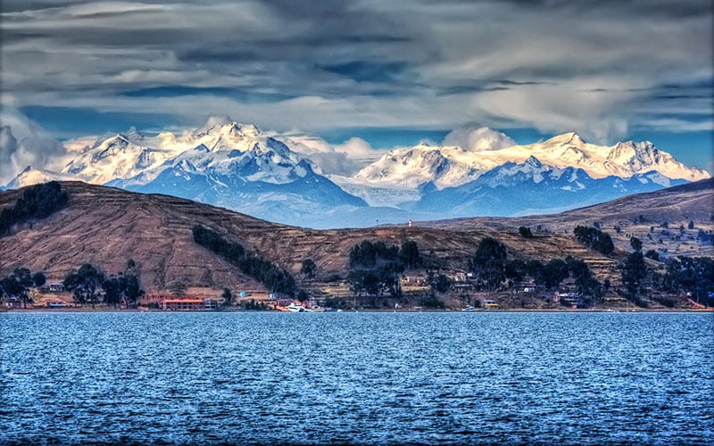
The largest lake on the mainland - Titicaca - is located on the Andean plateau at an altitude of more than 3800 m, on the border between Peru and Bolivia. Its area is 8300 km 2, and the maximum depth is 281 m. Terraces are pronounced on the shores of the lake, indicating a repeated decrease in its level. The lake has a drain into another, shallower tectonic lake - Poopo. The water in Lake Titicaca is fresh, while in Poopó it is highly saline.
On the internal plateaus of the Andes and on the plain of the Gran Chaco, there are many lakes of tectonic origin, shallow, endorheic and saline. In addition, saline marshes and salt marshes (“salares”) are common.
Along the low-lying shores of the Atlantic Ocean and the Caribbean Sea there are large lagoon lakes. The largest of these lagoons is located in the north, in a vast depression between the Andes ranges. It is called Maracaibo and is connected to the Gulf of Venezuela. The area of this lagoon is 16.3 thousand km 2, the length is 220 km. The water in the lagoon is almost fresh, but during high tides, its salinity increases markedly.
Lagoons that have almost lost contact with Atlantic Ocean are located in the southeast of the mainland. The largest of them are Patus and Lagoa Mirin.
A significant part of the continent, especially the Out-Andean East, has large reserves of groundwater. In the sandy strata, syneclises are not only in the Amazon, but also in the Guiana lowland, Llanos-Orinoco, Gran Chaco, Pampas, and also in other areas, up to 40-50% of the runoff falls on groundwater.

waterfalls
Angel Falls (Angel) or Salto Angel (Salto Angel) - the world's highest free-falling waterfall with a height of 978 meters.
Angel Falls is located in the highlands of Guyana, one of the five topographic regions of Venezuela, in South America. It is located on the Carrao River. The Carrao River is a tributary of the Caroni River which eventually flows into the Orinoco. It is not easy to get to the waterfall, as it is located in a dense tropical forest. There are no roads leading to the falls.
Angel Falls falls from the top of a flat mountain, called "tepui" by the natives. A flat mountain called Auyan Tepuy (Devil's Mountain) is one of more than a hundred like it, scattered in the Guiana Highlands in southeastern Venezuela. These dormant giants are characterized by their massive heights soaring into the sky, with flat tops and completely vertical slopes. Tepui, also called "table mountains" (which accurately describes their shape), formed from sandstone billions of years ago. Their vertical slopes are continuously destroyed under the influence of heavy rains falling on the Guiana Highlands.
The natives of Venezuela have known about "Salto Angel" since time immemorial. The waterfall was originally discovered in 1910 by a Spanish explorer named Ernesto Sanchez La Cruz. However, it was not known to the world until the official discovery by the American pilot and gold digger James Crawford Engel, after whom he was named. Angel was born in Springfield, Missouri in 1899.
This enterprising experienced pilot flew over the area in 1935 and landed on the top of a lonely mountain in search of gold. His monoplane "Flamingo" got stuck in the swampy jungle at the top, and he noticed a rather impressive waterfall extending thousands of feet down. He didn't have much luck with the 11-mile hike back to civilization, and his plane was left chained to the mountain, a rusting monument to his discovery. Soon the whole world learned about the waterfall, which became known as Angel Falls, in honor of the pilot who discovered it.
Jimmy Angel's plane remained in the jungle for 33 years before being picked up by helicopter. It is currently housed in the Aviation Museum in Maracay. The one you can now see on top of the tepui is a replica of it.
The official height of the waterfall was determined by the expedition of the National Geographic Society in 1949. The waterfall is the main attraction of Venezuela.
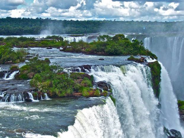
Iguazu Falls is a wonder of the world, consisting of 275 different cascades of water, the total area of which is 2700 square meters, and the fall height reaches 82 meters! The width of the waterfall is about 3 km. The largest waterfall is Devil's Throat, a U-shaped cliff 150 meters wide and 700 meters long, marking the border between the countries of Argentina and Brazil. The name "Iguazu" comes from the Guarani words for "water" and "big".
Many islands separate the waterfalls from each other. Approximately 900 meters out of a total width of 3 km. not covered with water. About 2 km. bridges connecting the islands help to better see all the streams. Most of the waterfalls are located within the territory of Argentina, however, from the Brazilian side, good view on Devil's Throat.
Iguazu Falls are considered the largest in the world in terms of the number of falls. During the rainy season in November - March, the flow rate of water can reach 750 cubic meters per second. The roar from falling water creates an impressive roar that can be heard even several kilometers away.
Smaller waterfalls are formed by ledges of solid rock, turning the water falling on them into clouds of mist and spray. Sunlight adds the finishing touch, creating iridescent rainbows. Below, in the midst of the water, miraculously rose an island covered with trees. On one side of the island, where the water flows calmly, there is a beach with yellowish sand.
The largest lake in South America and one of the oldest lakes on our planet, located in Venezuela. The lake is surrounded by colorful and rich vegetation and animal world. Its coast and bottom are the place of oil and gas production. On the shore of the lake is the economic center of the country - the city of Maracaibo. An amazing natural phenomenon takes place over the lake - the "lightning of Catatumbo". Atmospheric discharges beat here 160 days a year for 10 hours a day.
LAKE OF DISCOVERY
In the history of Lake Maracaibo, the two most important dates are August 24, 1499, when the Spaniards discovered it, and 1914, when the first oil wells were drilled on its coast.
The bowl-depression of Lake Maracaibo (or, in other words, the deflection of the tectonic plate of the Northwestern Andes) was formed approximately 36-22 million years ago. This is one of the oldest lakes on Earth. Archaeologists in Venezuela believe that people appeared on its shores about 15,000 years ago. The first European who brought caravels here along the Tablaso Strait was Alonso Ojeda, one of the officers of Columbus, whom he entrusted with an independent expedition. It is known that Amerigo Vespucci, an Italian living in Spain, was also with Ojeda at that time, the same one after whom the New World became America. It is believed that when he saw the houses on the piles of the Parauhano Indians, he exclaimed: “Oh, Veneciola!” (“Oh, little Venice!”), and thus the name Venezuela was born. Several legends are associated with the name of the lake. In the most stable of them, there is a cacique (leader) of the Motilon Indians named Mara, who fought with the colonialists at the beginning of the 16th century. When Mara was hit by a bullet, his warriors shouted "Mara cayo!" ("Mara fell!"). Some historians believe that the name Maracaibo appeared earlier and it comes from the name of the adjacent swamps - Maara-Ivo - "Snake Place".
The city of Maracaibo was founded three times. In 1525, Emperor Charles V transferred the right to rule Venezuela to the German bankers Welsers for 12 barrels of gold for 30 years. In 1529, on the site of the village of Villa de Maracaibo, Ambrosius Eichinger (Ambrose Alfinger in the Spanish version) built a port. By 1535 life in the city had died out. Alonso Pacheco founded it again in 1569, but the war with the Indians prevented him from continuing what he started. Only the third attempt was successful, by Petro Maldonado, in 1571. In the 17th century. the port of Maracaibo was often attacked by pirates. The history of its capture by Henry Morgan is described in R. Sabatini's novel "The Odyssey of Captain Blood". The transformation of a small town into an economic center began in 1918, when oil and gas production took on an industrial scale.
Lake Maracaibo is, strictly speaking, a lagoon of the Venezuelan Gulf of the Caribbean Sea, connected to it by a narrow shallow strait of Tablaso, the width of which is 8-10 km, the natural depth was 2-4 m, in 1957 it was deepened to 10-14, 5 m, for the passage of ocean-going vessels. The lake is located in the northwest of Venezuela in a tectonic depression between the Sierra de Perija in the west and the Cordillera de Merida in the south and east.
PAINTS OF MARCAIBO
The world of this lake is rich, colorful and known for one of the rarest natural phenomena.
The vegetation of the shores of the lake varies along the north-south axis. The shores of the Tablaso Strait are covered with typical savanna grasses, to the south the relief of the shores rises, more and more rivers flow into the lake, the water becomes more and more fresh, and on the southern coast of the lake, above the swampy lagoons with mangroves, a dense tropical forest rises like a wall, which is home to many animals . The screams of howler monkeys are heard far away. Plantations of sugar cane and cocoa trees spread over the drained areas. The 1806 testimony of the French ambassador in Caracas Francois Poe about the Guajiro Indians is interesting: “They are brave warriors, skillfully manage their canoes, all as one are excellent swimmers and divers. At the same time, they fantasize a lot, and write down something all the time, obviously having a penchant for writing. Their women are no less artistic, but they are distinguished by great common sense. Creative talent in the form of guajiro and parauhano is still noticeable today. Women wear wide, bright and long dresses called manti. Men - wide shirts, decorated with many beads sewn on by their girlfriends, great needlewomen; skilfully crocheted snow-white napkins with the Maracaibo Sun pattern are the main souvenir of the lake.
A rare natural phenomenon takes place above Maracaibo, called the “Lighthouse of Catatumbo”. A lighthouse - because the light from the lightning that flashes at night over the confluence of this river into the lake is visible 400 km away. Lightning strikes in these places more than 160 days a year, 10 hours a day, about 300 times per hour. Catatumbo lightning is considered the largest natural ozone generator on Earth. And this phenomenon occurs when an atmospheric vortex from the warm air of the Caribbean Sea and cold air from the tops of the Andes mixes with methane gas rising from the swamps.
CURIOUS FACTS
■ The Yupa Indians believe that Catatumbo's lightning comes when fireflies collide with the souls of their ancestors.
■ Gaitassulianas is the name of the musical style of Venezuelan folk music, born on the banks of Maracaibo. These melodies incorporate elements of salsa and meringue. It is popular throughout Latin America and is performed most often during the Christmas holidays.
ATTRACTION
■ Rafael Urdanet Bridge (1962, length - 8769 m, maximum height - 45 m), named after the hero of the national liberation movement of Venezuela.
■ Maracaibo: Carabobo street (colonial architecture), Palacio de Gobierno (Palace of Eagles - based on the figures of four condors on the roof), Cathedral Maracaibo (XVI-XVII centuries), the Cathedral of the Blessed Virgin Rosario Chiquinquira, or "La Chinita" (XIX century), the churches of Iglesia de Santa Barbara and Iglesia de Santa Lucia, Baralt Theater (XIX century BC) ), La Chinita Memorial, Los Bermudez Art Center, Vereda del Lago Park on the shore of Lake. maracaibo, Botanical Garden, Historical Museum, Military History Museum.
■ Fort of the 17th century. on about. San Carlos.
■ national park Cienagas del Catatumbo (included in the provisional UNESCO World Heritage List).
Atlas. The whole world is in your hands #146

- Brazilian, or giant otter. Likes quiet backwaters, grows up to 2 meters in length. One of the largest predators of the Amazon. It can even eat a boa constrictor or a python for lunch. Giant otters live in large family clans.
- Amazonian caimans play the role of a crocodile here, caimans eat capybaras with pleasure.
- The wedge-bellied or flying fish of the Amazon. Fleeing from predators, it can jump 120 cm out of the water with the help of well-developed pectoral fins.
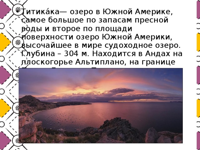
- Titicaca is a lake in South America, the largest in terms of reserves fresh water and the second largest lake in South America by surface area, the world's highest navigable lake. Depth - 304 m. Located in the Andes on the Altiplano plateau, on the border of Peru and Bolivia. The basin area is 8372 km 2 .

- Guanaco - this is the name of a relatively small humpless camel, which has a very wide habitat. It is found in grassy areas ranging from the province of Buenos Aires to the Argentinean Patagonia, sometimes also living in the Andean region.
- The longest-legged species of wolves is the maned one. This owner of a yellow-red skin lives in the central and south of it in the South. America.

Lake Titicaca is a popular American attraction. This creation of nature is located in the north of Antiplano. The lake is alpine, as it is located at an altitude of 4 thousand meters above sea level. It is famous for being located in the Andes range, where there is a large variety of various volcanoes. Lake Titicaca is the largest navigable lake in the world. The reservoir itself has boundaries in different countries South America. In the west, the lake is adjacent to Peru, and in the east to Bolivia. Lake Titicaca is being studied by many scientists. The age of the reservoir is about 100 million years. Scientists say that this lake was previously on the same level with the sea.
Researchers on Lake Titicaca have found many interesting finds. The most popular find is the remains of an ancient temple and its walls and bridges. The age of the find is about 1.5 thousand years. Scientists have no idea who could have owned this structure. The lake grew along with the Andes ridge, and turned out to be on such high altitude. The structure of the lake is very interesting, and if you look at it from above, it resembles a cougar.
The area of the lake is more than 8 thousand square kilometers. The reservoir is considered freshwater, since it contains no more than 1% salt. Another attraction of Lake Titicaca is the presence of many islands. In addition, water flows from the lake into many rivers that are located in South America. The level of the lake rises during heavy rains, and falls during the winter, when there is no heavy rainfall.

ancient people The Incas considered this lake to be their cradle. In order to see all the sights of the Incas, you need to go to Bolivia. Particularly interested people can book a tour of the sacred islands of Titicaca. On the islands that are in the reservoir, there are reserves, as well as various natural attractions. At the bottom of the lake, researchers find fossils of marine life. It is worth saying that the depth of the reservoir is quite large and is about 300 meters in some places. The average summer temperature in the vicinity of the lake does not exceed 20 degrees. There are no hot summers and cold winters, so travelers can enjoy the view of the beautiful Titicaca Lake at any time of the year. Here you will find unique nature, wildlife, as well as a sea of positive emotions.