Foreign Europe (without CIS) consists of more than 40 countries, whose total area is more than 5 million km 2.
Countries of foreign Europe They are distinguished by the advantageous economic and geographical position: highly developed countries are adjacent to the compact territory, a dense network of various transport communications has been formed, the vast majority of European countries have access to the sea. Only 12 countries of foreign Europe have an intracontinental position: Luxembourg, Switzerland, Liechtenstein, Austria, Czech Republic, Serbia, Slovakia, Hungary, Macedonia, Andorra, Vatican and San Marino. The island countries are Iceland, Ireland, the United Kingdom and Malta, and the peninsular countries are Norway, Sweden (Scandinavian Peninsula), Denmark (Jutland Peninsula), Portugal, Spain (Iberian Peninsula), Italy, San Marino, Vatican (Apennine Peninsula), Greece, Albania, Bulgaria, Serbia, Montenegro, Macedonia, Croatia, Bosnia and Herzegovina, Romania (Balkan Peninsula).
On political map of Europethere is only one colonial possession - Gibraltar, owned by the UK.
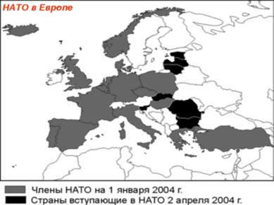
Most European countries are republics, but Europe is distinguished by the largest number of constitutional monarchies (Norway, Sweden, Denmark, Great Britain, the Netherlands, Belgium, Luxembourg, Liechtenstein, Andorra, Spain, Monaco). The Vatican is the only absolute theocratic monarchy in Europe. The administrative-territorial structure is dominated by unitary states. The federal structure has Belgium, Germany, Spain, Switzerland, Austria, Bosnia and Herzegovina. More than 20 Euro-Pei countries are members of the NATO military bloc, and Sweden, Switzerland and Austria pursue a policy of neutrality. Material from the site
All countries of Western Europe are classified as developed capitalist countries, and all countries of Eastern Europe are countries with a transitional type of economy. According to the level of socio-economic development among the countries of Western Europe, Germany, France, Great Britain and Italy are especially distinguished - members of the “Big Seven,” most of the countries of Central and Northern Europe belong to the group of small, highly developed countries, and Ir- landia, Iceland, Portugal and Greece, a special group are the dwarf states of Europe - the Vatican, San Marino, Monaco, An-dorra, Liechtenstein.
On this page, material on the topics:
Capital - Berlin
Population - 80.2 million people (2000)
Area - 356.8 thousand km sq.
United Kingdom of Great Britain and Northern Ireland
Capital London
Population - 59.0 million people (2000)
Area - 244.1 thousand km sq.
1. Economic and geographical position and.
Germany and Great Britain occupy a favorable EGP, although there are certain differences between them. Germany is located at the crossroads of transport routes, the most important of which have a latitudinal direction. Of particular importance for the country is direct access to the North Sea, on the coast of which there are several ports of world significance (Hamburg).
Great Britain - Island state. It is located at the crossroads of international shipping lanes. EGP of the country improved after the completion of the construction of the tunnel, which was laid in the narrowest spot of the English Channel and connects about. Great Britain with the mainland.
Germany - Federation of historical German lands. After the unification of the two German countries in a single state in 1990, there are 16. Each of the lands has its own constitution, its own parliaments and governments, but the entire legislative power in the state belongs to the bicameral parliament, and executive power is exercised by the government, headed by the Federal Chancellor. Germany is a federal republic by state system.
The United Kingdom of Great Britain and Northern Ireland includes:
- England;
- Scotland;
- Wales;
- Northern Ireland.
Great Britain leads the British Commonwealth of Nations, which includes 50 former English colonies and modern possessions. According to the state system, Great Britain is a parliamentary monarchy in which legislative power belongs to the monarch and parliament, and the real power belongs to the Cabinet of Ministers, which forms the ruling party.
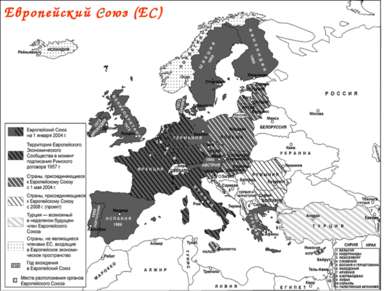
Both countries are members The EU and .
2. Natural conditions and resources of Germany and Great Britain
Both countries are limited and depleted, because they are exploited for a long time. Both countries have significant reserves of coal. In the UK, oil and natural gas are extracted from the shelf of the North Sea, and in Germany, besides coal, brown coal deposits are developed. Countries are rich in reserves of potash and salt.
Deposits of iron ore are practically exhausted and currently do not matter much. In the UK there are minor deposits of lead-zinc, copper and tin ores.
3. The population of Germany and Great Britain
The population of Germany, unlike Great Britain, was largely influenced by World War II, during which 10 million people died. However, the country quickly regained its population thanks to the return of 11 million Germans from territories that, as a result of changing German borders in 1945, moved to other countries. Now the Germans are returning to Germany from Russia and Kazakhstan. Natural growth in both the UK and Germany is very low, for several years there has even been a decrease in population.
Germany - a multinational country, and in the UK, except for the British (80%), Scots, Welsh (Welsh), and Irish live. These peoples retained their customs, culture and religion. In the UK there are a significant number of immigrants from former colonies.
The population is unevenly distributed, most of all it is concentrated in the industrially developed parts of the country. The average population density is almost the same - about 230 people / km sq. At the same time, in the Ruhr (Germany), the population density reaches 2000 people / km2. England is densely populated in Great Britain (350 people / km2).
Both countries stand out for their extremely high levels of urbanization. About a third of the townspeople live in large cities and metropolitan areas. In both countries, megacities have formed.
In the structure of employment, about 60% in Germany and 70% in the UK work in the service sector, the share of workers in industry fell to 37.7% in Germany and 27% in the UK, and 4% and 2%, respectively, are employed in agriculture.
4. General characteristics of the economy of Germany and the UK
Both countries are among the most developed countries of the world that are part of the G-7; their economy has a post-industrial character. However, Germany is significantly ahead of Britain in economic development. Germany is the most developed country in Western Europe, it produces 30% of the GNP of the EU countries, and ranks third in terms of GNP in the world (8% of the world) after the United States and Japan. It is often called the "locomotive" of Western Europe.
The stable pace of economic development in Germany did not decrease even after 1990, when the GDR was included in its structure. East Germany developed on the basis of a centrally planned economy and was closely connected with other countries of the socialist camp. After the merger, the need for structural adjustment and industry in East Germany arose. This requires significant costs from the government, which in the future will be able to produce a tangible effect.
1 slide
2 slide
Europe ... This geographical name is what we are talking about? Foreign Europe is one of the centers of world civilization, the birthplace of the great geographical discoveries, industrial upheavals, urban agglomerations, and international economic integration. This region today occupies a very important place in world politics and economics. It is a geographical region in the west of Eurasia, with an area of \u200b\u200b10 million km2, including 5.1 million km2 in Europe (in relation to the CIS), which makes up about 4% of all inhabited land. The territory of foreign Europe stretches from North to South from Spitsbergen to Crete for 5 thousand km, from West to East from the Atlantic coast of Portugal to the Black Sea coast of Romania for 3100 km.
3 slide
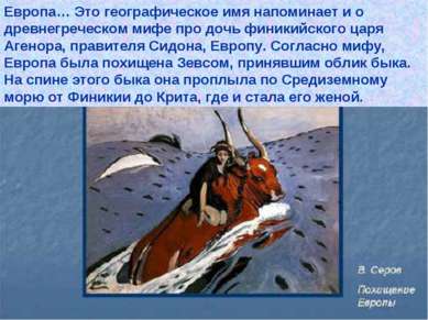
Europe ... This geographical name also recalls the ancient Greek myth about the daughter of the Phoenician king Agenor, ruler of Sidon, Europe. According to myth, Europe was abducted by Zeus, who took the form of a bull. On the back of this bull, she sailed through the Mediterranean Sea from Phenicia to Crete, where she became his wife.
4 slide
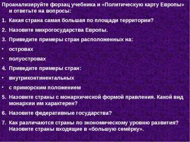
One of the associations with the name Europe is a region, i.e. mosaic of countries. Analyze the flyleaf of the textbook and the “Political Map of Europe” and answer the questions: Which country has the largest territory? What are the microstates of Europe. Give examples of countries located on: islands of the peninsulas. Give examples of countries: inland with a coastal position. Name the countries with a monarchical form of government. What kind of monarchy is characteristic of them? What are the federal states? How do countries differ in terms of economic development? What are the countries in the G7?
5 slide
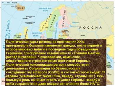
Political map of the region during the XX century. underwent major changes three times: after the first and second world wars and in recent years (the unification of Germany, the independence of the Baltic countries, the collapse of Yugoslavia, Czechoslovakia, the change in the social system in Eastern Europe). The political consolidation of the region is facilitated by the activities of the Organization for Security and Cooperation in Europe (OSCE), which includes 53 countries (it also includes the United States, Canada, and the CIS countries). The Council of Europe is beginning to play an increasingly important role. Along with this, the influence of the NATO bloc remains and even grows.
6 slide
7 slide
8 slide
What features characterize the features of the EGP region? T. 6 § 1 p. 1 ……………………………. ……………………………….
9 slide
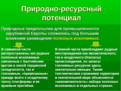
Natural resource potential Natural prerequisites for the industry of foreign Europe have developed under the great influence of the location of minerals. In the northern part, both ore minerals associated with the Baltic Shield and the Hercynian folding zone are widespread, as well as fuel minerals, “tied” primarily to the sedimentary cover of the platform and its marginal troughs. In the southern part, ore deposits of both igneous and sedimentary (bauxite) origin prevail, but fuel reserves are much smaller. Such a tectonic structure of the territory largely explains the “incompleteness” of the set of minerals in individual countries.
10 slide
Natural and resource potential The hydropower resources of foreign Europe are quite large, but mainly in the areas of the Alps, Scandinavian and Dinar mountains. In many countries they are already fully used. Natural preconditions for the region's agriculture are relatively favorable and have been widely used for many centuries. As a result, reserves for expanding cultivated land are almost exhausted, and the “load” on them is increasing. Therefore, small coastal countries, and especially the Netherlands, continue to attack the coastal areas of the seas. Agro-climatic resources of the region are determined by its position in the temperate, and in the south - in the subtropical zones. In the Mediterranean, sustainable agriculture needs artificial irrigation. Most irrigated land in Italy and Spain. Sweden and Finland have the greatest natural prerequisites for forestry, where typical forest landscapes predominate: forests cover lowlands and hills, rivers and lakes, and approach settlements. No wonder the people say: "Finland is without a forest, that a bear is without wool." Foreign Europe also has large and diverse natural and recreational resources.
11 slide
Population Recently, the population of foreign Europe began to grow very slowly. This is due to the fact that the reproduction of the population of the region is characterized by a difficult demographic situation. In some countries there is a population decline, depopulation that demographic policies cannot prevent. Such depopulation is reflected in age-gender pyramids with a “narrowed” base. At the same time, the age composition of the population is changing, the proportion of older people is growing. All this led to a sharp change in the region’s share in the global system of external migration. Having been the main focus of emigration since the Great Geographical Discoveries, foreign Europe has become the main global focus of labor immigration. Now there are 12-13 million foreign workers and members of their families, a significant part of whom are not citizens, but temporary guest workers (in German “guest workers”). For countries accepting a large number of labor migrants (as well as refugees), such an influx of people creates many complex problems. It affects the population, its reproduction, age and gender structure, location, and especially on the quality of the population.
12 slide
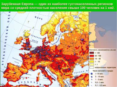
Foreign Europe is one of the most densely populated regions of the world with an average population density of over 100 people per 1 km2.
13 slide
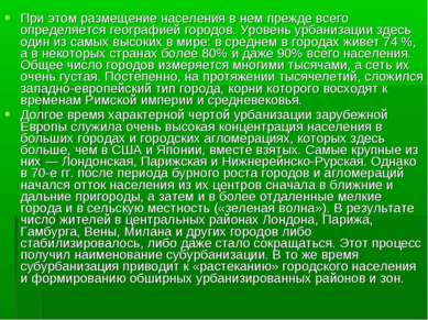
Moreover, the population distribution in it is primarily determined by the geography of cities. The level of urbanization here is one of the highest in the world: on average 74% live in cities, and in some countries more than 80% and even 90% of the total population. The total number of cities is measured in many thousands, and their network is very dense. Gradually, over the millennia, a Western European type of city developed, the roots of which date back to the times of the Roman Empire and the Middle Ages. For a long time, a very high concentration of the population in large cities and urban agglomerations, which are more numerous here than in the USA and Japan combined, has been a characteristic feature of urbanization of foreign Europe. The largest of them are London, Paris and Nizhneraine-Ruhr. However, in the 70s. after a period of rapid growth of cities and agglomerations, an outflow of population from their centers began, first to the near and far suburbs, and then to more distant small towns and rural areas (the “green wave”). As a result, the number of residents in the central regions of London, Paris, Hamburg, Vienna, Milan and other cities either stabilized or even began to decline. This process is called suburbanization. At the same time, suburbanization leads to the “spreading” of the urban population and the formation of vast urbanized areas and zones.
14 slide
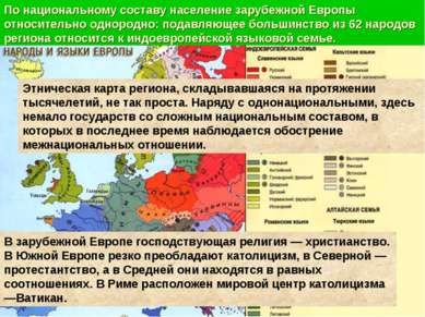
The national composition of the population of foreign Europe is relatively uniform: the vast majority of the 62 peoples of the region belong to the Indo-European language family. The ethnic map of the region that has evolved over millennia is not so simple. Along with uninational, there are many states with complex ethnic composition, in which there has recently been an aggravation of interethnic relations. In foreign Europe, the dominant religion is Christianity. Catholicism sharply prevails in Southern Europe, Protestantism in Northern Europe, and in Central Europe they are in equal proportions. In Rome, the world center of Catholicism is the Vatican.
15 slide
Practical work. Studying the problem of natural and labor resources in the process of integration of countries of foreign Europe 1. On the contour map of Europe, apply the most important mineral deposits of foreign Europe. 2. Use the symbols on the map to indicate the main regions where non-mineral resources are located: forest, fish, agro-climatic, hydropower, and geothermal. 3. On a separate leaflet attached to the card, write down the countries most and least endowed with natural resources of the countries of Foreign Europe. 4. What are the main suppliers and indicate the most preferred ways for European countries to move the main types of raw materials: oil and gas, coal, ferrous and non-ferrous ores.